
Coolidge Dam facts for kids
Quick facts for kids Coolidge Dam |
|
|---|---|

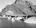
Upstream face of Coolidge Dam, from Historic American Engineering Record
|
|
| Country | United States |
| Location | Gila County and Pinal County, Arizona |
| Coordinates | 33°10′29″N 110°31′40″W / 33.174687°N 110.527863°W |
| Status | Operational |
| Construction began | 1924 |
| Opening date | 1930 |
| Construction cost | US$10 million ($131 million in 2021 dollars ) |
| Owner(s) | Bureau of Indian Affairs |
| Dam and spillways | |
| Type of dam | Arch dam |
| Impounds | Gila River |
| Height | 249 ft (76 m) |
| Elevation at crest | 2,535 ft (773 m) |
| Width (crest) | 580 ft (180 m) |
| Dam volume | 200,000 cu yd (150,000 m3) |
| Spillways | 2 |
| Spillway type | Ogee |
| Reservoir | |
| Creates | San Carlos Reservoir |
| Total capacity | 910,000 acre⋅ft (1.12×10⁹ m3) |
| Power station | |
| Commission date | 1935 |
| Decommission date | 1983 |
| Type | Conventional |
| Turbines | 2 × 5 MW |
| Installed capacity | 10 MW |
|
Coolidge Dam
|
|
| Lua error in Module:Location_map at line 420: attempt to index field 'wikibase' (a nil value). | |
| Area | 21 acres (8.5 ha) |
| Built | 1927 |
| Built by | Major C.R. Olberg; Atkinson, Kier Bros. & Spice Co. |
| Architect | Herman Neuffer |
| Architectural style | Multiple Dome Dam |
| NRHP reference No. | 81000135 |
| Added to NRHP | October 29, 1981 |

The Coolidge Dam is a large dam made of reinforced concrete. It is located about 31 miles (50 km) southeast of Globe, Arizona, on the Gila River. This special dam was built between 1924 and 1928. It was a key part of the San Carlos Irrigation Project, which helps farmers get water.
The dam was named after the 30th US president, Calvin Coolidge. President Coolidge himself officially opened the dam on March 4, 1930. Herman Neuffer was the engineer who designed and oversaw its construction. He worked for the Bureau of Indian Affairs (BIA) on many projects in Arizona and New Mexico during the 1920s.
Coolidge Dam creates San Carlos Lake on the San Carlos Apache Indian Reservation. The water from the dam helps irrigate about 100,000 acres (40,000 ha) of farmland. Because the water is stored and released only when farmers need it, San Carlos Lake is often quite low. It only fills up a lot during very wet times.
When President Coolidge dedicated the dam in 1930, the lake had not even started to fill. A famous humorist named Will Rogers saw the grass growing in the lake bed. He joked, "If this were my lake, I'd mow it!"
Contents
History of the Dam

Building the Dam
The Coolidge Dam was built by the Bureau of Indian Affairs (BIA). Construction took place between 1924 and 1928. It cost about US$10 million to build. The BIA still owns and operates the dam today.
The dam is made of 200,000 cubic yards (150,000 m3) of concrete. It has three large dome-shaped sections. These domes are held up by strong supports called buttresses, spaced 100-foot (30 m) apart. The dam stands 249 feet (76 m) tall. Its top, or crest, is 580 feet (180 m) long. There are two spillways, which are like giant drains, on each side of the dam. These spillways help release extra water safely.
Concerns from the Apache Tribe
Building the dam caused some concerns for the Apache tribe. They worried that the dam would affect their treaty rights. It would also cover important tribal lands and sites with water.
After discussions, a compromise was reached with the Apache people. A concrete slab was placed over a main tribal area that would be covered by the lake. This was done to show respect for the tribe's heritage and important places.
Making Electricity
The Coolidge Dam used to generate electricity. It was part of the San Carlos Indian Irrigation Project (SCIIP). A hydroelectric plant at the dam produced power starting in 1935. This electricity helped power irrigation wells, local towns, and even mining operations.
Later, in 1983, a big flood damaged the hydroelectric station. It stopped working after that. Now, the electricity for the project comes from a different source.
Dam Upgrades and Safety
In 1988, a study showed that the dam needed some upgrades. These changes would help it stay safe during a very big flood or an earthquake. Earlier floods had worn away parts of the dam's sides. Also, some of its supports were thought to be unstable.
Work to strengthen the dam began in 1991 and finished in 1995. These improvements helped make the dam much safer. The total cost for these upgrades was about US$46.5 million.
The Big Flood of 1993
In January 1993, Arizona had a lot of rain. It rained up to three times the normal amount. This caused San Carlos Lake to fill up completely. The dam operators had to release a huge amount of water.
The ground was already soaked, so all the new rain flowed quickly into rivers. Also, the weather was warmer than usual. This meant that snow in the mountains melted into rain instead of staying as snow. Rivers in southern Arizona had much more water than normal.
Because the lake was so full, the Coolidge Dam released water at record levels. The water flow was very strong. It caused damage to some gas pipelines and a bridge downstream. The amount of water flowing into San Carlos Lake during January 1993 was huge. The water released from Coolidge Dam reached about 927 cubic metres per second (32,700 cu ft/s). This was about seven times more than the dam was expected to release! Even with all this water, the dam held strong. This showed that the dam was able to handle a very large flood.
Fun at the Lake

Fishing and Boating
San Carlos Lake is a great place for outdoor fun. When there has been enough rain, it becomes one of Arizona's largest lakes. The San Carlos Apache Tribe manages the lake for recreation and wildlife. They add different types of fish to make fishing good.
Some fish species live in the lake all the time, including:
- Sunfish
- Largemouth bass
- Black crappie
- Channel catfish
- Flathead catfish
Other fish, like brown trout and rainbow trout, are added from cold-water fish farms. You can also enjoy jet-skiing, water skiing, and boating on the lake. If you are not a member of the San Carlos Apache tribe, you need to get a permit from the tribal office to use the lake. This is because the lake is on tribal land.
Biking Trail
Bicyclists can ride on the access road that leads to the dam. The path is very scenic and usually does not have much traffic. The ride goes up about 700 feet over 13 miles. The elevation at the dam is similar to the starting point. The path goes up in the middle and then goes down again.
When you reach the dam, you can ride back the way you came. Or, you can continue east on a rougher part of the road until it meets U.S. Route 70. Remember, if you are not a tribe member, you need a permit to travel on the reservation. For the rougher eastern part of the trail, a mountain bike or a similar sturdy bicycle is best.
Images for kids
-
Upstream face of Coolidge Dam, from Historic American Engineering Record
-
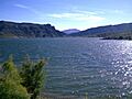
View of the lake, 2010
-
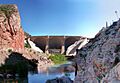
Coolidge Dam from downstream, showing its unique reinforced concrete multiple dome and buttress construction. 2009 photo
-
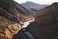
Gila River downstream from Coolidge Dam
