North Fork Clearwater River facts for kids
Quick facts for kids North Fork Clearwater River |
|
|---|---|

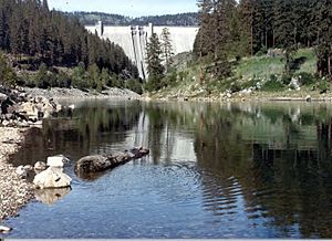
Dworshak Dam on the North Fork Clearwater, near its mouth
|
|
|
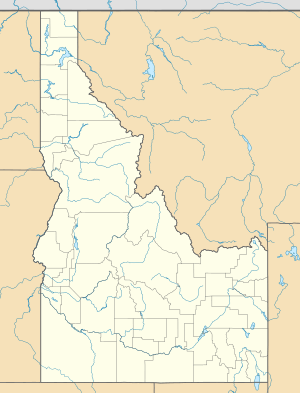
Location of the mouth of the North Fork Clearwater River in Idaho
|
|
| Other name(s) | North Fork of the Clearwater River, The North Fork |
| Country | United States |
| State | Idaho |
| Physical characteristics | |
| Main source | Bitterroot Mountains Illinois Peak, Shoshone County 5,400 ft (1,600 m) 47°00′11″N 115°06′16″W / 47.00306°N 115.10444°W |
| River mouth | Clearwater River Ahsahka, Clearwater County 980 ft (300 m) 46°30′00″N 116°19′50″W / 46.50000°N 116.33056°W |
| Length | 135 mi (217 km) |
| Basin features | |
| Basin size | 2,462 sq mi (6,380 km2) |
| Tributaries |
|
The North Fork Clearwater River is a big river in Idaho, a state in the United States. It's a main branch of the Clearwater River. This river starts high up in the Bitterroot Mountains in eastern Idaho.
It flows for about 135 miles (217 km) towards the west. Near its end, the river is held back by the huge Dworshak Dam. The river's basin, or watershed, covers a large area of about 2,462 square miles (6,376 km²). This area is mostly managed by the U.S. Forest Service.
Contents
River's Journey: Where Does It Flow?
The North Fork Clearwater River begins in the Bitterroot Mountains. These mountains form the eastern border of Idaho with Montana. Its source is near Graves Peak, Illinois Peak, and Gold Crown Peak. It's also close to St. Joe Lake, which is where the St. Joe River starts.
The river quickly flows southwest through a narrow valley. Many smaller streams join it along the way. It then turns southeast, meeting Long Creek and Lake Creek. After these, the river turns west again.
Key Tributaries and Turns
As the river continues, it receives Elizabeth Creek from the right. It then makes a sharp turn west into a wider valley. Here, it meets its biggest branch so far, Kelly Creek, which is about 25 miles (40 km) long. This happens near a small community.
The river then flows west and southwest, with Forest Service Road #250 running alongside it. More creeks join, including 4 July Creek, Weitas Creek, Orogrande Creek, and Quartz Creek.
Entering Dworshak Reservoir
After flowing northeast and then swinging back west, Skull Creek joins the river. Beaver Creek comes in from the south, and Isabella Creek from the north. The river then enters Dworshak Reservoir. This large lake was formed by the massive Dworshak Dam.
About 8 miles (13 km) into the reservoir, the flooded canyon meets the Little North Fork Clearwater River. This branch is also flooded for some distance. The reservoir stays narrow at first, following the river's original path. It then branches south and gets wider as the land becomes flatter. Reeds Creek and Elk Creek, which used to be major branches of the river, now flow directly into the lake.
Meeting the Clearwater River
The reservoir ends at the Dworshak Dam. This dam is a huge concrete wall, 717 feet (219 m) high. Below the dam, the river flows southeast for a little over a mile. It goes under Idaho State Route 7 before joining the main Clearwater River at a place called Ahsahka.
River's Home: The Watershed
The North Fork Clearwater River's watershed is the land area that drains into it. This area covers about 2,462 square miles (6,376 km²) in the lower part of the Idaho Panhandle. This is about 26.6% of the entire Clearwater River watershed. The Clearwater River itself flows into the Snake River.
The North Fork's watershed borders other river areas. To the north is the St. Joe River basin. To the northeast is Latah Creek. The Middle Fork Clearwater is to the east and south. The South Fork Clearwater and Snake River are to the south. Finally, the Potlatch River and the main Clearwater River are to the west.
Life in the Watershed
This river basin is not very crowded with people. The biggest and only town is Elk River, Idaho, with a population of about 149 people. The main way people make a living here is through the logging industry.
The most important branches flowing into the North Fork Clearwater River are Kelly Creek, the Little North Fork Clearwater River, and Elk Creek.
River Flow
On average, the North Fork Clearwater River flows at about 5,200 cubic feet per second (147 m³/s). This flow can change a lot, from about 1,000 cubic feet per second (28 m³/s) to over 30,000 cubic feet per second (850 m³/s).
The USGS measured the river's flow near its mouth for many years. The highest flow they recorded was 100,000 cubic feet per second (2,800 m³/s) on December 23, 1933.
Wildlife and Nature
The North Fork Clearwater River and its surrounding area are home to many amazing animals. You might spot grizzly bears and black bears. There are also cougars, deer, moose, elk, and grey wolves. Birds like osprey can be seen fishing in the waters.
Fish in the River
The river is full of different kinds of fish. Some common ones include westslope cutthroat trout, rainbow trout, and mountain whitefish. The bull trout is also found here, but it is a threatened species, meaning its numbers are low.
You can also find smallmouth bass and kokanee salmon in the river. These fish come from Dworshak Reservoir. Before the Dworshak Dam was built, the river used to have a very large run of steelhead, which are a type of salmon.
The North Fork of the Clearwater River is located within the beautiful Clearwater National Forest.
 | Laphonza Butler |
 | Daisy Bates |
 | Elizabeth Piper Ensley |


