
Potlatch River facts for kids
Quick facts for kids Potlatch River |
|
|---|---|

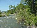
The Potlatch near Kendrick
|
|

Map of the Clearwater River watershed showing the Potlatch River in the upper left
|
|
| Country | United States |
| State | Idaho |
| Region | Latah County, Clearwater County, Nez Perce County |
| Physical characteristics | |
| Main source | Hoodoo Mountains Confluence of East and West Forks Rocky Mountains, Latah County 2,674 ft (815 m) 46°55′43″N 116°20′55″W / 46.92861°N 116.34861°W |
| River mouth | Clearwater River Between Myrtle and Spalding, Nez Perce County 801 ft (244 m) 46°28′31″N 116°46′02″W / 46.47528°N 116.76722°W |
| Length | 56 mi (90 km), Northeast-southwest |
| Basin features | |
| River system | Clearwater River |
| Basin size | 594 sq mi (1,540 km2) |
| Tributaries |
|
The Potlatch River flows through Idaho in the United States. It's about 56 miles (90 km) long. The Potlatch River flows into the Clearwater River. The Clearwater River then joins the Snake River, which finally flows into the mighty Columbia River.
Long ago, this area was covered in dry grasslands near the Rocky Mountains. Today, people mainly use the Potlatch River for agriculture and irrigation. Its name comes from "potlatch," a special ceremony held by Native American people in the Pacific Northwest. One such tribe lived along this river for hundreds of years.
In the late 1800s, settlers came and started farms and ranches. Later, logging removed most of the forests. The river's environment is still recovering from these changes. Today, many people enjoy Fishing, hiking, and camping along the river. About 14 percent of the land around the river is public land. Before farming and logging, many different plants grew here. Several types of fish still live in the river and its smaller streams.
Contents
River's Journey: Where the Potlatch Flows
The Potlatch River begins in the Hoodoo Mountains. It flows southwest across the eastern Columbia Plateau, which is a dry area near the Rocky Mountains. The river starts from two main branches, called forks. The West Fork is in Latah County, and the East Fork is in Clearwater County.
These two forks meet near Helmer. After that, the river drops into a deep canyon. This canyon continues all the way to where the river ends. While in the canyon, other smaller streams join the Potlatch River. These include Pine, Big Bear, Middle Potlatch, and Little Potlatch Creeks from the north. Boulder and Cedar Creeks join from the south.
Idaho State Highway 3 follows part of the lower canyon. The town of Juliaetta is located where Middle Potlatch Creek meets the river. The Potlatch River finally joins the Clearwater River at an elevation of 801 feet (244 m). This meeting point is between the towns of Myrtle and Spalding.
The river's average water flow at its mouth is about 379.8 cubic feet per second (10.75 m3/s). This measurement comes from a USGS station. The highest flow recorded there was 8,150 cubic feet per second (231 m3/s) in 2006. The river has the most water in winter and early spring. It becomes very small by summer and autumn. The river mainly flows over basalt rocks. These rocks make up the Columbia Plateau.
Potlatch River: A Look at Its Past
The Nez Perce tribe, a Native American group, has lived along the Potlatch River for hundreds of years. The area used to be mostly dry grasslands with forests in the mountains nearby. Because it's close to the Rocky Mountains, the Potlatch River gets more rain than other rivers to the west.
In 1805 and 1806, the Lewis and Clark Expedition passed the mouth of the Potlatch River. They were traveling down the Clearwater River. They called it "a large creek" and named it Colter's Creek. This was to honor John Colter, who was part of their journey. We don't know if they were the first white people to see the river. The river got its modern name, Potlatch, in 1897.
The natural environment stayed mostly the same until many settlers arrived in western Idaho in the 1870s. Miners also came because gold was found nearby in Orofino. Many of these new settlers started farms and ranches in the grasslands around the Potlatch River. The soil is better for growing crops as you go south through the area. However, getting water was a big problem in the southern part of the river basin.
Water was already scarce in the dry Potlatch River area. Plus, the river flows through a steep canyon for most of its lower part, making the water hard to reach. Farmers could only grow crops that didn't need much irrigation. Many lands without enough water were used for pasture or growing hay.
At first, the forests were not greatly affected. But after logging began around 1900, most of the old, untouched trees were cut down. The first sawmills were built to provide wood for local needs, like building houses and barns. Soon, the Washington, Idaho and Montana Railway extended its tracks into the area. This allowed lumber to be shipped out of the basin. Logging became very profitable. However, it had a lasting negative effect on the environment of the Potlatch River.
Loggers used different methods to get timber. These included splash dams, greased chutes, and special railroad lines. Unfortunately, building railroad tracks often straightened the smaller streams. This caused more erosion on the bare hillsides. As a result, many streams became much muddier than they naturally would be. Nearly all the old-growth forest in the area is now gone. The forests that remain are mostly younger, second-growth trees.
Nature and Wildlife: The Potlatch Ecosystem

The river's area was once covered by grasslands. These grasslands had plants like Idaho fescue and bluebunch wheatgrass. Along the river banks, you could find cottonwoods, quaking aspen, maple, and alder trees. In the foothills, there were meadows with black hawthorn, snowberry, and small conifer trees. Along smaller streams, hawthorn and mock orange grew.
Camas flowers and other plants thrived in the wet areas along the river. The forests were mostly a mix of Douglas fir and ponderosa pine. There were also some rare stands of grand fir, western redcedar, western white pine, and larch. Underneath these trees, plants like oceanspray, ninebark, serviceberry, wild rose, and snowberry grew. Wildfires used to burn through the area sometimes, helping new plants grow. After people arrived, these plants still existed, but in smaller numbers. Most of the grasslands have been replaced by farms.
The amount of rain each year ranges from 15 to 50 inches (380 to 1,270 mm). Temperatures usually vary from 25 to 100 °F (−4 to 38 °C).
Fish and Aquatic Life
A study from 2003–2004 found 13 different types of fish in the Potlatch River. These included speckled dace, longnose dace, rainbow trout (both wild and farm-raised), brook trout, largemouth bass, pumpkinseed, northern pikeminnow, redside shiner, sculpin, bridgelip sucker, largescale sucker, and yellow perch.
The building of dams on the Snake and Columbia Rivers has affected the migration of steelhead. Steelhead are a type of rainbow trout that live in the ocean and return to freshwater to lay eggs. The two types of dace fish were the most common fish in the area. Steelhead made up 58.4% of the total fish weight. The West Fork Potlatch River had the most different types of fish. This is because it is still in a very natural condition. The lower part of the river suffers from pollution from farm runoff.
From 2005 to 2008, a program called PRSME tracked steelhead trout. There was no data for the main river. However, 197 adult steelhead were found in the East Fork. An average of 226 steelhead were found each year in Big Bear Creek, a larger stream. In good years, over 1,000 steelhead are thought to return to the Potlatch area. Young steelhead (smolt) leaving the East Fork were estimated at 6,976 fish. The average for Big Bear Creek was 9,491. In 2009, the Idaho Department of Fish and Game started seven projects to help protect fish homes in the Potlatch.
How Land is Used Around the River
About 57% of the Potlatch River area is covered by forests. Around 38% is used for agriculture and ranching. Most of the land, 78%, is privately owned. About 14% is part of national forests. The state owns 7% of the land. The Bureau of Land Management and Bureau of Indian Affairs each own 1%.
Fun Activities: Recreation on the Potlatch
Many of the mountains and forests in the river area are protected as national forest lands. There are several campgrounds managed by the U.S. Forest Service. These are located near where the Potlatch River begins.
Fishing is also good in the Potlatch River and its smaller streams. Anglers (people who fish) are only allowed to catch brook trout, cutthroat trout, and rainbow and steelhead trout. The Department of Fish and Game adds fish to the river every year. You can fish on the Potlatch from its mouth up to where Moose Creek joins the river near Bovill. Fishing is also allowed on the East Fork.
Images for kids
-
The Potlatch at average early summer flow
