Juliaetta, Idaho facts for kids
Quick facts for kids
Juliaetta
|
||
|---|---|---|
|
City
|
||

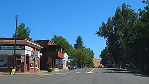
Main Street
|
||
|
||

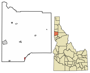
Location of Juliaetta in Latah County, Idaho.
|
||
| Country | United States | |
| State | Idaho | |
| County | Latah | |
| Settled | 1878 | |
| Incorporated (town) | April 19, 1892 | |
| Area | ||
| • Total | 0.71 sq mi (1.84 km2) | |
| • Land | 0.70 sq mi (1.81 km2) | |
| • Water | 0.01 sq mi (0.03 km2) | |
| Elevation | 1,063 ft (324 m) | |
| Population
(2010)
|
||
| • Total | 579 | |
| • Density | 861.03/sq mi (332.53/km2) | |
| Time zone | UTC-8 (Pacific (PST)) | |
| • Summer (DST) | UTC-7 (PDT) | |
| ZIP Code |
83535
|
|
| Area code(s) | 208 | |
| FIPS code | 16-42130 | |
| GNIS feature ID | 2410155 | |
Juliaetta is a small city in Latah County, Idaho, United States. It was named after the daughters of an early settler. In 2020, about 624 people lived in Juliaetta.
Contents
History of Juliaetta
Juliaetta was first called Schupferville. It was named after Rupert Schupfer, who settled the land in 1878. He set aside part of his land for a town and opened the first general store. By 1878, about 200 people lived there.
In 1876, Charles Snyder started a post office. He named the town Juliaetta after his daughters, Julia and Etta. He was the first postmaster. The city officially became a city in 1892 when the railroad reached it.
Early Businesses and Growth
In 1885, the first flour mill was built in Juliaetta. The flour was called “Pride of the Potlatch” and was sent all over the western United States. This business later became the Juliaetta Milling and Light Company.
By 1889, the town had many businesses. These included a bank, a newspaper, a jewelry store, and a store for saddles. Farmers in the area grew wheat, flax, oats, and hay. They also had fruit trees and large gardens.
The town became an official city in 1892. Farm products were moved using a special tram from the hills around town. By 1902, Juliaetta had two hotels: the Grand Central Hotel and the Palace Hotel. Dr. Robert Foster Sr. opened Foster's School of Healing in 1903.
The Juliaetta Cannery was a big business that hired 100 people during certain seasons. It could produce up to 10,000 cans of food each day. Sadly, it burned down in 1911.
In the early 1900s, Juliaetta had even more businesses. There was a general store, funeral homes, a barber, and places for shoeshines. There were also shops for hats, candy, and clothes. For fun, people could go to a skating rink, a dance hall, an opera house, and a theater.
Geography of Juliaetta
Juliaetta is located about 2 miles (3.2 km) north of the Nez Perce Indian Reservation. The Potlatch River flows next to Highway 3 on the east side of Juliaetta.
The city covers a total area of about 0.73 square miles (1.89 square kilometers). Most of this area, about 0.72 square miles (1.86 square kilometers), is land. A small part, about 0.01 square miles (0.03 square kilometers), is water.
Population and People
| Historical population | |||
|---|---|---|---|
| Census | Pop. | %± | |
| 1900 | 287 | — | |
| 1910 | 414 | 44.3% | |
| 1920 | 427 | 3.1% | |
| 1930 | 274 | −35.8% | |
| 1940 | 337 | 23.0% | |
| 1950 | 365 | 8.3% | |
| 1960 | 368 | 0.8% | |
| 1970 | 423 | 14.9% | |
| 1980 | 522 | 23.4% | |
| 1990 | 488 | −6.5% | |
| 2000 | 609 | 24.8% | |
| 2010 | 579 | −4.9% | |
| 2020 | 624 | 7.8% | |
| U.S. Decennial Census | |||
Juliaetta's Population in 2010
In 2010, there were 579 people living in Juliaetta. These people lived in 263 homes, and 163 of those were families. Most of the people living in Juliaetta were White (95.7%). There were also small numbers of African American, Native American, and people of two or more races. About 1.4% of the population was Hispanic or Latino.
The average age of people in Juliaetta was 46.8 years old. About 18.7% of the residents were under 18 years old. About 20.9% were 65 years or older. The population was almost evenly split between males (49.2%) and females (50.8%).
Arts and Culture in Juliaetta
Juliaetta has two places that are listed on the National Register of Historic Places. This means they are important historical sites.
- The Bank of Juliaetta was built in 1889 and is now a restaurant.
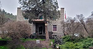
- The Abram A. Adams House was built in 1905. It looks like a Scottish castle and is now a museum.
The Juliaetta Community Library opened in 1977. It is part of the Latah County Library District.
Parks and Outdoor Fun
The Corkill Memorial Trail is a paved path that is 5.3 miles (8.5 km) long. It runs along the Potlatch River between Juliaetta and Kendrick. This trail was built on an old railroad line from the 1890s. The trail ends at Juliaetta Centennial Park, which also has a baseball field.
Education in Juliaetta
Juliaetta is part of the Kendrick Joint School District. The elementary school is in Juliaetta. The high school is in the nearby town of Kendrick. Together, they are known as Kendrick Joint School District 283.
See also
 In Spanish: Juliaetta para niños
 | Delilah Pierce |
 | Gordon Parks |
 | Augusta Savage |
 | Charles Ethan Porter |


