Orofino, Idaho facts for kids
Quick facts for kids
Orofino, Idaho
|
|
|---|---|

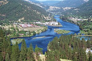
Clearwater River near Orofino
|
|

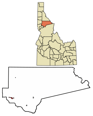
Location of Orofino in Clearwater County, Idaho.
|
|
| Country | United States |
| State | Idaho |
| County | Clearwater |
| Area | |
| • Total | 2.61 sq mi (6.76 km2) |
| • Land | 2.46 sq mi (6.38 km2) |
| • Water | 0.15 sq mi (0.38 km2) |
| Elevation | 1,286 ft (392 m) |
| Population
(2020)
|
|
| • Total | 2,656 |
| • Density | 1,257.71/sq mi (485.63/km2) |
| Time zone | UTC-8 (Pacific (PST)) |
| • Summer (DST) | UTC-7 (PDT) |
| ZIP code |
83544
|
| Area code(s) | 208 |
| FIPS code | 16-59320 |
| GNIS feature ID | 2411336 |
Orofino (pronounced oro-FEE-noh) is a city in Clearwater County, Idaho, United States. Its name means "fine gold" in Spanish. Orofino is the main city within the Nez Perce Indian Reservation. It is located along Orofino Creek and the north bank of the Clearwater River. In 2010, about 3,142 people lived there.
Near Orofino is the historic "Canoe Camp." This is where the famous Lewis and Clark expedition built five new canoes. They started their journey downstream to the Pacific Ocean from here on October 7, 1805. About 4 miles (6.4 km) north of the city, you can find the Dworshak Dam. This dam was finished in the early 1970s and is the third-highest dam in the United States. Close by is the Dworshak National Fish Hatchery. This hatchery was built to help replace the fish that could no longer swim upstream because of the dam.
The name "Oro Fino" first belonged to a gold mining camp. This camp was set up in 1861, about 2 miles (3.2 km) south of Pierce. In 1895, the United States government opened the Nez Percé reservation to new settlers. Thousands of European Americans quickly came to claim land. Clifford Fuller created a trading post on his new homestead. The town of Orofino-on-the-Clearwater was officially started the next year. A railroad, which later became part of the Camas Prairie Railroad, was built from Lewiston in 1899.
Orofino is home to state facilities, including the Idaho State Hospital North. The city also has Orofino High School, which includes middle school grades. Orofino hosts fun events each year. These include a July 4 celebration and the Clearwater County Fair and Lumberjack Days in late summer. Every spring, a special rifle event called Boomershoot takes place nearby.
Contents
City Landscape and Location
Orofino is located in a beautiful part of Idaho. The city covers about 2.47 square miles (6.40 square kilometers). Most of this area, about 2.33 square miles (6.03 square kilometers), is land. The rest, about 0.14 square miles (0.36 square kilometers), is water, mainly from the Clearwater River.
Weather in Orofino
Orofino has a climate that is common for lower areas in Idaho. Summers are usually warm and dry. The highest temperature ever recorded in Idaho was in Orofino. It reached 118°F (48°C) on July 28, 1934. Winters are cold, with some snow.
| Climate data for Orofino, Idaho (1971-2000) | |||||||||||||
|---|---|---|---|---|---|---|---|---|---|---|---|---|---|
| Month | Jan | Feb | Mar | Apr | May | Jun | Jul | Aug | Sep | Oct | Nov | Dec | Year |
| Record high °F (°C) | 62 (17) |
68 (20) |
82 (28) |
98 (37) |
105 (41) |
115 (46) |
118 (48) |
116 (47) |
107 (42) |
92 (33) |
71 (22) |
62 (17) |
118 (48) |
| Mean daily maximum °F (°C) | 37.7 (3.2) |
45.8 (7.7) |
55.4 (13.0) |
64.0 (17.8) |
72.0 (22.2) |
79.7 (26.5) |
88.9 (31.6) |
90.2 (32.3) |
78.8 (26.0) |
63.2 (17.3) |
46.1 (7.8) |
37.3 (2.9) |
63.3 (17.4) |
| Mean daily minimum °F (°C) | 25.2 (−3.8) |
28.0 (−2.2) |
32.0 (0.0) |
37.8 (3.2) |
44.1 (6.7) |
50.3 (10.2) |
53.7 (12.1) |
52.9 (11.6) |
45.3 (7.4) |
36.4 (2.4) |
31.1 (−0.5) |
26.2 (−3.2) |
38.6 (3.7) |
| Record low °F (°C) | −11 (−24) |
−9 (−23) |
12 (−11) |
27 (−3) |
28 (−2) |
35 (2) |
41 (5) |
39 (4) |
28 (−2) |
15 (−9) |
1 (−17) |
−15 (−26) |
−15 (−26) |
| Average precipitation inches (mm) | 2.91 (74) |
2.66 (68) |
2.53 (64) |
2.40 (61) |
2.59 (66) |
1.67 (42) |
1.06 (27) |
0.88 (22) |
1.24 (31) |
1.98 (50) |
3.38 (86) |
3.29 (84) |
26.59 (675) |
| Average snowfall inches (cm) | 12.0 (30) |
3.9 (9.9) |
1.3 (3.3) |
0.1 (0.25) |
0.0 (0.0) |
0.0 (0.0) |
0.0 (0.0) |
0.0 (0.0) |
0.0 (0.0) |
0.0 (0.0) |
1.3 (3.3) |
7.9 (20) |
26.5 (66.75) |
| Source 1: NOAA (normals, 1971-2000) | |||||||||||||
| Source 2: Western Regional Climate Centre (snowfall, 1948-1981) | |||||||||||||
Population and People
The number of people living in Orofino has changed over the years.
| Historical population | |||
|---|---|---|---|
| Census | Pop. | %± | |
| 1910 | 384 | — | |
| 1920 | 537 | 39.8% | |
| 1930 | 1,078 | 100.7% | |
| 1940 | 1,602 | 48.6% | |
| 1950 | 1,656 | 3.4% | |
| 1960 | 2,471 | 49.2% | |
| 1970 | 3,883 | 57.1% | |
| 1980 | 3,711 | −4.4% | |
| 1990 | 2,868 | −22.7% | |
| 2000 | 3,247 | 13.2% | |
| 2010 | 3,142 | −3.2% | |
| 2019 (est.) | 3,099 | −1.4% | |
| U.S. Decennial Census | |||
2010 Census Information
In 2010, there were 3,142 people living in Orofino. They lived in 1,167 households, with 698 of these being families.
- Most people (91.7%) were White.
- About 2.5% were Native American.
- Other groups included African American, Asian, and people of two or more races.
- About 4.3% of the population identified as Hispanic or Latino.
The average age of people in Orofino was 43.7 years old.
- 17% of residents were under 18 years old.
- 20.1% were 65 years old or older.
- There were more males (58.3%) than females (41.7%) in the city.
Getting Around Orofino
US 12 is the main highway that serves Orofino. It is a two-lane road that runs along the south bank of the Clearwater River. A bridge connects the city to this highway. US 12 links Orofino to Lewiston in the west. It also connects to Missoula, Montana, in the east, going over Lolo Pass. This route is known as the "Northwest Passage Scenic Byway." Most people in Orofino rely on cars to get around. The city has few sidewalks.
For those traveling by small aircraft, the Orofino Municipal Airport (KS68) is available.
See also
 In Spanish: Orofino para niños
 | Aaron Henry |
 | T. R. M. Howard |
 | Jesse Jackson |


