
Kootenay Lake facts for kids
Quick facts for kids Kootenay Lake |
|
|---|---|

Map of Kootenay Lake, British Columbia
|
|

Kootenay Lake
Location in British Columbia
|
|
| Location | Kootenay region, British Columbia |
| Coordinates | 49°38′N 116°55′W / 49.633°N 116.917°W |
| Primary inflows | Kootenay River |
| Primary outflows | Kootenay River |
| Basin countries | Canada |
| Max. length | 104 km (65 mi) |
| Max. width | 5 km (3.1 mi) |
| Average depth | west arm 10 m (33 ft), main lake 45 m (148 ft) |
| Max. depth | 150 m (490 ft) |
| Residence time | avg. 1.5 years |
| Surface elevation | 532 m (1,745 ft) |
| Settlements | Nelson, British Columbia |
Kootenay Lake is a large lake located in British Columbia, Canada. It is part of the Kootenay River system. The lake's water level has been changed by the Corra Linn Dam. Also, a system of dikes at its southern end, along with industries from the 1950s to 1970s, have changed the plants and animals living in and around the water.
The Kootenay Lake Ferry is a free ferry that runs all year. It crosses the lake between Kootenay Bay and Balfour. Kootenay Lake is a popular place for tourists to visit in the summer.
Contents
Geography of Kootenay Lake
Kootenay Lake is a long, narrow, and deep lake. It is shaped like a fjord, which is a long, narrow, deep inlet of the sea between high cliffs. This lake sits between the Selkirk and Purcell mountain ranges in the Kootenay region of British Columbia.
It is one of the biggest lakes in British Columbia. It is about 104 km (65 mi) long and 3–5 km (2–3 mi) wide. The lake is partly a wider section of the Kootenay River. This river then flows into the Columbia River system near Castlegar, British Columbia.
Lake Shape and Water Flow
The lake mostly runs north to south. However, a western arm stretches about 35 km (22 mi) towards the City of Nelson. The lake is 532 m (1,745 ft) above sea level. The mountains next to it rise up to about 2,700 m (8,900 ft) high.
Water stays in the main lake for about 1.5 years on average. But the west arm's water changes much faster, in about 3–4 days.

How Kootenay Lake Was Formed
Kootenay Lake was created first by erosion from rivers. Later, glaciation helped shape it. Erosion started a long time ago, during the late Cretaceous period. Then, during the Pleistocene Ice Age, ice filled the valley.
When the valley was full of ice, glaciers from the Selkirk and Purcell mountains fed this huge ice mass. A glacier in what is now the west arm of Kootenay Lake flowed into the main Kootenay ice mass. As this ice melted, water drained over an area near Nelson. This caused the west arm of the lake to drain towards the west.
A large moraine (a pile of rocks and dirt left by a glacier) formed near a big bend in the Kootenay River, close to Libby, Montana. As the ice melted, a lake formed behind this moraine. This lake drained south over the moraine. Eventually, the southern drainage stopped, and the Kootenay River began to flow in its path we see today.
History of Kootenay Lake
Kootenay Lake is part of the traditional lands of the Sinixt and Ktunaxa peoples. These native groups used the lake and its rivers for their seasonal travels and for trading goods.
Power Line and Dikes
In 1958, an electrical power line called the Kootenay Lake Crossing was built. It ran across the northern part of Kootenay Lake. In 1962, some protestors destroyed it, but it was rebuilt later that same year.
The lake used to flood a large marsh area, about 80 km (50 mi) long, to its south. This area is now the Creston Valley Wildlife Management Area. However, this land has since been surrounded by dikes. It is now used for agriculture. A smaller wetland area in this region has been protected.
Dams and Water Control
In 1931, the Corra Linn Dam was built where Kootenay Lake flows back into the river. This dam helps control floods and makes electricity in the winter. It raises the normal water level by two meters. Just downstream are Bonnington Falls, where several hydroelectric dams now stand. In 2003, the lake released 16.9 billion cubic meters of water. The high water level that year was 533 meters, which is normal. The highest recorded level was 537 meters in 1961.
As part of the Columbia River Treaty, the Duncan Dam was built in 1967. It is located above Kootenay Lake on the Duncan River. This dam created a large reservoir of 7,145 hectares (17,660 acres) to control water flow. Also part of the treaty, the Libby Dam in Montana was finished in 1975.
Animals of Kootenay Lake
Many types of fish live in Kootenay Lake. These include Rainbow trout, Bull Trout, Burbot, Mountain Whitefish, White Sturgeon, Brook Trout, Largemouth Bass, Yellow Perch, and Kokanee Salmon.
Kokanee Salmon Decline
The number of Kokanee salmon in the west arm of the lake dropped a lot in the late 1970s. Because of this, fishing for salmon was stopped in 1980 and is still closed today. The exact reason for this decline is not fully known.
Some ideas for the decline include:
- Fewer Mysis relicta (small shrimp-like creatures) in the west arm. These were put into the lake in 1949 to be food for the Kokanee. Their numbers might have dropped because water levels were controlled more strictly.
- Damage to the places where young fish grow. This could be due to the lake's water levels going up and down often.
- Less food for bottom-dwelling creatures because fewer nutrients entered the lake after a fertilizer plant closed.
- Too much fishing in the 1960s and 1970s.
- Competition between the Mysis relicta and young fish for food.
In 1990, the Kokanee salmon in the southern part of the lake were almost gone. An experiment to add fertilizer to the lake was started, and it has had some success in helping the salmon numbers.
Human Use and Impact on the Lake
Settlements Around the Lake
About 19,700 people live within 2.5 km (1.6 mi) of Kootenay Lake's shore. About 10,250 of these people live in the City of Nelson. The rest live in several smaller towns and villages, such as:
- Kuskonook, Columbia
- Boswell, British Columbia
- Crawford Bay, British Columbia
- Ainsworth Hot Springs, British Columbia
- Kaslo, British Columbia
- Riondel, British Columbia
- Balfour, British Columbia
- Grey Creek, British Columbia
- Kootenay Bay, British Columbia
- Harrop, British Columbia
- Procter, British Columbia
- Sirdar, British Columbia

Upstream Influences on Water Quality
In 1953, the water quality in Kootenay Lake got worse. This happened when the Cominco phosphate fertilizer plant opened on the Kootenay River near Kimberley. A lot of phosphorus entered the Kootenay River. This caused large blooms of cyanobacteria (also known as blue-green algae) from the 1950s until the early 1970s.
This plant closed in 1973, which stopped these phosphates from entering the river. The building of the Libby Dam on the Kootenai River in Montana and the Duncan Dam in 1967 on the Duncan River also helped. Together, these dams further reduced the natural phosphorus levels in the lake from their previous high amounts.
Kootenay Lake Ferry Service

The Kootenay Lake Ferry crosses the lake. It is a free ferry for vehicles and runs between Balfour and Kootenay Bay. Two ferry boats operate during the summer, and one operates during the winter.
Images for kids
-
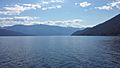
Kootenay Lake with Old Tom Mountain in the background
-
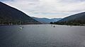
The Big Orange Bridge across Kootenay Lake, West Arm
-
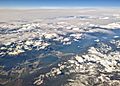
Aerial view of the south end of Kootenay Lake, with Duck Lake


See also
 In Spanish: Lago Kootenay para niños
