
Payette River facts for kids
Quick facts for kids Payette River |
|
|---|---|

The lower course of the Payette River
|
|

Map of the Payette River watershed
|
|
| Other name(s) | South Fork Payette River |
| Country | United States |
| State | Idaho |
| Region | Payette County |
| City | Emmett |
| Physical characteristics | |
| Main source | North Fork Payette River Deep Lake, Boise County 7,380 ft (2,250 m) 45°10′47″N 115°59′37″W / 45.17972°N 115.99361°W |
| 2nd source | South Fork Payette River A small unnamed lake near Vernon Lake, Boise County 8,820 ft (2,690 m) 43°57′51″N 115°00′02″W / 43.96417°N 115.00056°W |
| River mouth | Snake River Payette, Payette County 2,125 ft (648 m) 44°05′32″N 116°57′09″W / 44.09222°N 116.95250°W |
| Length | 83 mi (134 km), East-West |
| Basin features | |
| River system | Snake River |
| Basin size | 3,240 sq mi (8,400 km2) |
| Tributaries |
|
The Payette River is a river in southwestern Idaho, USA. It is about 83-mile-long (134 km) and flows into the Snake River. The river starts high in the Sawtooth and Salmon River Mountains. These mountains are over 10,000 feet (3,000 m) high.
The water in the Payette River basin mainly flows from east to west. The river and its branches cover an area of about 3,240 square miles (8,400 km2). The Payette River ends in an area used for farming. It joins the Snake River near the city of Payette.
Contents
River Branches and Flow
The Payette River has two main branches: the North Fork and the South Fork. These branches join to form the main river.
North Fork Payette River
The North Fork Payette River drains about 950 square miles (2,500 km2) of land. It begins north of McCall and flows into Payette Lake. From Payette Lake, it flows south through "Long Valley" in Valley County. It then enters Cascade Reservoir. After the reservoir, it continues south, following Highway 55.
South Fork Payette River
The South Fork Payette River drains a larger area, about 1,200 square miles (3,100 km2). It starts on the west side of the Sawtooth Wilderness. This is near Mount Payette, which is 10,211-foot (3,112 m) tall. The South Fork flows past Grandjean and Lowman, along Highway 21.
Middle Fork and Main River
The Middle Fork Payette River flows south, about 10 miles (16 km) east of the lower North Fork. It joins the South Fork near Crouch. The Deadwood River also flows into the South Fork near Lowman. The main Payette River begins where the South Fork and Middle Fork meet.
The North Fork joins the main Payette River at a place called Banks. This is at an elevation of 2,790 feet (850 m). The main river then flows south for 15 miles (24 km) to Horseshoe Bend. After that, it turns west into Black Canyon Reservoir. Below the dam, the river flows past Emmett and Payette. Finally, it empties into the Snake River at the border with Oregon.
History of the Payette River Area

Native American groups like the Shoshone, Nez Perce, Paiute, and Bannock lived in the Payette River area long ago. They did not have permanent villages. In fall and winter, they camped in the lower valley of the Payette River. In spring and summer, they moved to the rich areas of lakes and wetlands along the North Fork. This area is now called Long Valley. They hunted and gathered food there for the winter.
A plant called Camas was very important to their diet. It grew widely in this area. To keep the camas fields healthy, they would set controlled fires when they moved camps. This also helped clear unwanted plants and protected their campsites.
European Explorers and Settlers
In the early 1800s, Europeans began exploring western Idaho. The river is named after Francois Payette. He was a French-Canadian fur trapper. He was one of the first Europeans to explore the Payette River basin. Payette worked for the North West Company. Later, he led the Hudson's Bay Company's Fort Boise trading post from 1835 to 1844.
Settlers from the eastern United States started arriving in large numbers after 1860. One of the first settlements was on Clear Creek, a branch of the South Fork Payette River. Many Native Americans were not happy with the new settlers. They felt their lands were being taken and damaged by mining, logging, and grazing. This led to conflicts, like the Nez Perce War in 1877.
Industries and Development
The Payette River basin had a lot of timber. So, logging became an important industry in the 1800s. It grew even more in the early 1900s. The demand for wooden railroad ties for the Oregon Short Line in the 1880s increased logging. A main logging center was in the southern part of Long Valley.
A special dam called a splash dam was built in 1902 on the North Fork. It helped move logs downstream. In 1911, the Idaho Northern Railroad was built. It ran along the Payette River from Emmett through Black Canyon and the North Fork. This railroad moved timber, animals, and crops.
Farming also grew a lot in the lower Payette River valley starting around 1874. This area is dry, so irrigation systems were needed. The Last Chance Canal and Nobel Canal were some of the first canals built to take water from the Payette River.
The U.S. Bureau of Reclamation (USBR) built Black Canyon Diversion Dam in 1924. This dam helped direct water into new canals, which greatly increased farming. To store water for the dry season, the USBR built Deadwood Dam in 1929. Later, Cascade Dam was built in 1948. It created a large lake called Cascade Reservoir and can store much more water than Deadwood Dam.
Fish and Reservoirs

The Payette River has many different types of fish. This is because the river flows through areas with very different elevations. Fish like Salmon and steelhead can no longer go up the river past the Black Canyon Diversion Dam, which was finished in 1924.
Below Black Canyon Dam, the river has both coldwater and warmwater fish. You can find Mountain whitefish, smallmouth bass, largemouth bass, channel catfish, black crappie, rainbow trout, and brown trout here. Upstream from the dam, the river gets steeper and colder. Here, you find more coldwater fish. The South Fork Payette River has many wild rainbow trout.
Major Reservoirs
There are five main reservoirs in the Payette basin: Black Canyon, Sage Hen, Paddock, Cascade, and Deadwood. There are also smaller dams and natural lakes that hold more water, like the three Payette Lakes.
- Black Canyon Reservoir on the main river is not great for fish because sand from upstream has covered much of the habitat.
- Paddock Reservoir has good populations of black crappie and largemouth bass.
- Cascade Reservoir on the North Fork is one of the most fished waters in Idaho. It has many yellow perch, coho salmon, and rainbow trout.
- Deadwood Reservoir, finished in 1931, has kokanee and cutthroat trout.
High up in the mountains, alpine lakes in the Payette River area are stocked with fish. These include rainbow trout, cutthroat trout, cutbow (a mix of rainbow and cutthroat trout), golden trout, and Arctic grayling. You can also find Brook trout in some of these lakes.
Whitewater Adventures
The Payette River is very well known for its exciting whitewater. Many people come here for kayaking and rafting.
North Fork Whitewater
Experts say the North Fork is one of the most challenging rivers for whitewater in North America. The lower North Fork, from Smith's Ferry to Banks, is great for kayaking. You can easily see it from Highway 55, which runs along the river. This part of the North Fork drops 1,700 feet (520 m) over 16 miles (26 km). This creates many Class V rapids, which are very difficult (see International Scale of River Difficulty). The water flow in the North Fork is controlled by the Cascade Dam. This dam helps keep the water relatively warm from the shallow Cascade Reservoir.
South Fork and Main River Whitewater
East of Banks, the South Fork's Canyon is a challenging Class IV run for rafting. Along this trip, there is a 40-foot (12 m) waterfall called Big Falls. This waterfall is a Class VI, meaning it's too dangerous to run and people must carry their rafts around it.
When the North Fork and South Fork join at Banks, they form the main Payette River. This part of the river offers a float trip with many Class III rapids. A scenic railroad, the Thunder Mountain Line, runs along the west side of this lower stretch of the river.
Images for kids
-
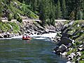
Rafters prepare for rapids on the North Fork near Banks, close to the beginning of the main stem of the Payette
See also
 In Spanish: Río Payette para niños
