Boise County, Idaho facts for kids
Quick facts for kids
Boise County
|
||
|---|---|---|

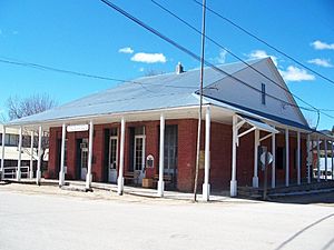
Boise County Courthouse in Idaho City
|
||
|
||

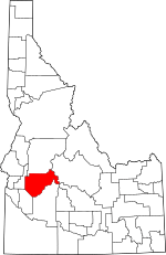
Location within the U.S. state of Idaho
|
||
 Idaho's location within the U.S. |
||
| Country | ||
| State | ||
| Founded | February 4, 1864 | |
| Named for | Boise River | |
| Seat | Idaho City | |
| Largest city | Horseshoe Bend | |
| Area | ||
| • Total | 1,907 sq mi (4,940 km2) | |
| • Land | 1,899 sq mi (4,920 km2) | |
| • Water | 7.4 sq mi (19 km2) 0.4% | |
| Population
(2020)
|
||
| • Total | 7,610 |
|
| • Density | 3.7/sq mi (1.4/km2) | |
| Time zone | UTC−7 (Mountain) | |
| • Summer (DST) | UTC−6 (MDT) | |
| Congressional district | 1st | |
Boise County is a beautiful mountain county located in the state of Idaho. It's a place with lots of nature and open spaces. In 2020, about 7,610 people lived here.
The main town, or county seat, is historic Idaho City. This town is connected by roads to other smaller communities like Lowman, Garden Valley, and Horseshoe Bend. Boise County is also part of the larger Boise area.
You can find the Bogus Basin ski area in the southwest part of the county. If you go further east, you'll discover parts of the amazing Sawtooth Wilderness and the Sawtooth National Recreation Area. These are popular spots for outdoor adventures!
In 2010, Boise County was special because it was considered the center of Idaho's population. This means it was the balancing point if you imagined everyone in Idaho standing on a map.
Contents
History of Boise County
Boise County was officially created on February 4, 1864. Its name comes from the Boise River. French-Canadian explorers and trappers named the river "Boise" because of the many different kinds of trees growing along its banks.
Gold Rush Days
The Boise Basin, where Idaho City is located, was once one of the richest gold mining areas in the country. Gold was first found here in 1862. More gold was discovered in Boise County than in the entire state of Alaska!
During the mid-1860s, Idaho City grew very quickly. It became the largest city in the Pacific Northwest. This fast growth led to the creation of the Idaho Territory in 1863. Towns like Horseshoe Bend and Boise were important stops for supplies heading to the gold mines.
Changing Borders
The borders of Boise County changed several times when Idaho was still a territory. Other counties like Owyhee County and Ada County were created from parts of Boise County. By 1918, after Gem County and Valley County were formed, Boise County got its current shape.
Geography and Nature
Boise County covers a large area of about 1,907 square miles. Most of this is land, with a small amount of water. The highest point in the county is Thompson Peak, which is 10,751 feet tall. It's located in the Sawtooth Wilderness on the eastern border. The lowest point is around 2,500 feet, near the Payette River.
The central part of the county is higher up, about 1,700 feet higher than Horseshoe Bend. This means it gets a lot more snow in winter! For example, roofs in Placerville need to be strong enough to hold 150 pounds of snow per square foot. In Horseshoe Bend, it's only about 52 pounds.
Neighboring Counties
Boise County shares its borders with several other counties:
- Valley County to the north
- Custer County to the east
- Elmore County to the south
- Ada County to the southwest
- Gem County to the northwest
Protected Natural Areas
A big part of Boise County is covered by beautiful protected areas:
- Boise National Forest (part)
- Sawtooth National Recreation Area (part)
- Sawtooth Wilderness (part)
Main Roads
The county has two main roads, which are also scenic byways:
 SH 21 - This is the Ponderosa Pine Scenic Byway. It goes from Boise to Idaho City and Lowman.
 SH 55 - This is the Payette River Scenic Byway. It's a special national scenic byway. It follows the Payette River from Eagle through Horseshoe Bend to towns like Cascade and McCall.
You won't find many traffic lights in Boise County. The closest thing is a flashing red light where Highway 52 meets Highway 55 in Horseshoe Bend.
Population Information
| Historical population | |||
|---|---|---|---|
| Census | Pop. | %± | |
| 1870 | 3,834 | — | |
| 1880 | 3,214 | −16.2% | |
| 1890 | 3,342 | 4.0% | |
| 1900 | 4,174 | 24.9% | |
| 1910 | 5,250 | 25.8% | |
| 1920 | 1,822 | −65.3% | |
| 1930 | 1,847 | 1.4% | |
| 1940 | 2,333 | 26.3% | |
| 1950 | 1,776 | −23.9% | |
| 1960 | 1,646 | −7.3% | |
| 1970 | 1,763 | 7.1% | |
| 1980 | 2,999 | 70.1% | |
| 1990 | 3,509 | 17.0% | |
| 2000 | 6,670 | 90.1% | |
| 2010 | 7,028 | 5.4% | |
| 2020 | 7,610 | 8.3% | |
| 2023 (est.) | 8,517 | 21.2% | |
| US Decennial Census 1790–1960, 1900–1990, 1990–2000, 2010–2020 |
|||
In 2010, Boise County had 7,028 people living there. Most people were white, and a small percentage were of Hispanic or Latino origin. Many families lived in the county, and the average age was about 48 years old.
Population Changes Over Time
The number of people living in Boise County has changed a lot over the years:
- 1863 - 16,835 (or 17,435)
- 1864 - 15,158
Towns and Communities
Boise County has several towns and smaller communities.
Cities
Census-Designated Places
These are areas that are like towns but are not officially incorporated as cities:
Unincorporated Communities
These are smaller settlements that are not part of any city or census-designated place:
- Brownlee
- Centerville
- Gardena
- Grandjean
- Grimes Pass
- New Centerville
- Pioneerville
- Quartzburg
- Washington Mill
Education in Boise County
Students in Boise County attend schools in several different school districts:
- Basin School District 72
- Boise City Independent School District 1
- Emmett Independent School District 221
- Garden Valley School District 71
- Horseshoe Bend School District 73
For higher education, residents are near the College of Western Idaho.
See also
 In Spanish: Condado de Boise para niños
 | Percy Lavon Julian |
 | Katherine Johnson |
 | George Washington Carver |
 | Annie Easley |


