Elmore County, Idaho facts for kids
Quick facts for kids
Elmore County
|
||
|---|---|---|

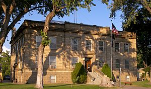
Elmore County Courthouse
|
||
|
||

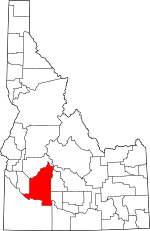
Location within the U.S. state of Idaho
|
||
 Idaho's location within the U.S. |
||
| Country | ||
| State | ||
| Founded | February 7, 1889 | |
| Named for | The Ida Elmore mines, producer of silver and gold in the 1860s | |
| Seat | Mountain Home | |
| Largest city | Mountain Home | |
| Area | ||
| • Total | 3,101 sq mi (8,030 km2) | |
| • Land | 3,075 sq mi (7,960 km2) | |
| • Water | 26 sq mi (70 km2) 0.8% | |
| Population
(2020)
|
||
| • Total | 28,666 | |
| • Density | 9.2441/sq mi (3.5692/km2) | |
| Time zone | UTC−7 (Mountain) | |
| • Summer (DST) | UTC−6 (MDT) | |
| Congressional district | 2nd | |
Elmore County is a county in the state of Idaho, USA. In 2020, about 28,666 people lived there. The biggest city and the main government center, called the county seat, is Mountain Home.
Elmore County is part of a larger area around Boise. This means it's connected to a bigger group of cities and towns for things like jobs and services.
Contents
A Look Back: History of Elmore County
Elmore County was officially created on February 7, 1889. Its first county seat was a place called Rocky Bar. The county got its name from the Ida Elmore mines. These mines were very important in the 1860s because they produced a lot of silver and gold.
Early Settlements and Mining
The famous Oregon Trail passed through Elmore County. It crossed the Snake River at a spot called Three Island Crossing, near Glenns Ferry. However, the first important towns in Elmore County were mining camps. These were mostly in the northern part of the county, near the old mining town of Rocky Bar.
People started settling in Rocky Bar in 1863. By that year, about 560 people lived there. Another town, Atlanta, was settled in 1864. The northern part of Elmore County was originally part of Alturas County. Rocky Bar was even the county seat for Alturas County for a while.
The southern part of Elmore County, south of the Snake River, used to be part of Owyhee County until 1930. Later, in 1948, a small piece of Ada County was added. This gave Elmore County the borders it has today.
Changes in the County Seat
Life in Rocky Bar was tough because of mining problems and its remote location. In 1882, the county seat was moved from Rocky Bar to Hailey. When Elmore County was created in 1889, Rocky Bar briefly became its county seat again.
A station on the old overland stage route, first called Rattlesnake, was moved west to the railroad line. This new location became the town of Mountain Home. On February 4, 1891, the county seat was officially moved to Mountain Home, where it remains today.
Important Developments
Construction of the Mountain Home Air Force Base started in October 1942. It's about twelve miles (19 km) southwest of Mountain Home. The base opened in August 1943. It was first used to train bomber pilots. Later, it became a base for fighter jets.
The Anderson Ranch Dam is located east of Mountain Home on the South Fork of the Boise River. When it was finished in 1950, it was the world's tallest earthfill dam.
Where is Elmore County?
The U.S. Census Bureau says Elmore County covers a total area of about 3,101 square miles (8,030 km2). Most of this, about 3,075 square miles (7,960 km2), is land. The rest, about 26 square miles (67 km2) (0.8%), is water.
The highest point in Elmore County is Snowyside Peak. It stands at about 10,651 feet (3,246 m) above sea level. This peak is in the northeast part of the county, within the Sawtooth Wilderness. The lowest point in the county is along the Snake River in the southwest. It is less than 2,500 feet (760 m) high.
Neighboring Counties
Elmore County shares its borders with several other counties:
- Boise County - to the north
- Ada County - to the west
- Owyhee County - to the south
- Twin Falls County - to the southeast
- Gooding County - to the east
- Camas County - to the east
- Blaine County - to the northeast
- Custer County - to the northeast
Main Roads
Several important highways run through Elmore County, connecting it to other parts of Idaho and beyond:
 I-84
I-84 I-84 Business Loop
 US 20
US 20 US 26
US 26 US 30
US 30 SH 51
SH 51 SH 67
SH 67- SH 78
- SH 167
Protected Natural Areas
Parts of Elmore County are home to beautiful national protected areas:
- Boise National Forest (part)
- Sawtooth National Forest (part)
- Sawtooth National Recreation Area (part)
- Sawtooth Wilderness (part)
- Snake River Birds of Prey National Conservation Area (part)
People of Elmore County
| Historical population | |||
|---|---|---|---|
| Census | Pop. | %± | |
| 1890 | 1,870 | — | |
| 1900 | 2,286 | 22.2% | |
| 1910 | 4,785 | 109.3% | |
| 1920 | 5,087 | 6.3% | |
| 1930 | 4,491 | −11.7% | |
| 1940 | 5,518 | 22.9% | |
| 1950 | 6,687 | 21.2% | |
| 1960 | 16,719 | 150.0% | |
| 1970 | 17,479 | 4.5% | |
| 1980 | 21,565 | 23.4% | |
| 1990 | 21,205 | −1.7% | |
| 2000 | 29,130 | 37.4% | |
| 2010 | 27,038 | −7.2% | |
| 2020 | 28,666 | 6.0% | |
| 2023 (est.) | 29,724 | 9.9% | |
| U.S. Decennial Census 1790–1960, 1900–1990, 1990–2000, 2010–2020 |
|||
Population in 2010
According to the 2010 United States Census, there were 27,038 people living in Elmore County. There were 10,140 households, which are groups of people living together. About 7,135 of these were families. The county had about 8.8 inhabitants per square mile (3.4/km2) people per square mile.
Most of the people in the county (82.2%) were white. Other groups included 2.8% Asian, 2.7% black or African American, and 1.0% American Indian. About 15.2% of the population were of Hispanic or Latino background.
Many families (38.6%) had children under 18 living with them. The average household had 2.60 people, and the average family had 3.11 people. The average age of people in the county was 30.0 years old.
The average income for a household was $43,089. For families, the average income was $50,840. About 12.0% of all people in the county lived below the poverty line. This included 19.3% of those under 18 and 7.8% of those aged 65 or older.
Towns and Communities
Elmore County has several cities and smaller communities where people live.
Cities
Census-designated Places
These are areas that are like towns but are not officially incorporated as cities.
- Hammett
- Mountain Home Air Force Base
Unincorporated Communities
These are smaller settlements that don't have their own local government.
Ghost Town
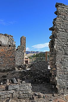
- Rocky Bar - This was once a busy mining town, but now it's mostly deserted.
Education in Elmore County
Students in Elmore County attend schools in several different school districts:
- Bliss Joint School District 234
- Bruneau-Grand View Joint School District 365
- Glenns Ferry Joint School District 192
- Mountain Home School District 193
- Prairie Elementary School District 191
For higher education, some parts of the county are near the College of Western Idaho. Other parts are near the College of Southern Idaho.
See also
 In Spanish: Condado de Elmore (Idaho) para niños
 | Lonnie Johnson |
 | Granville Woods |
 | Lewis Howard Latimer |
 | James West |


