Placerville, Idaho facts for kids
Quick facts for kids
Placerville, Idaho
|
|
|---|---|

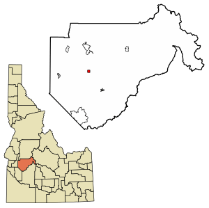
Location of Placerville in Boise County, Idaho.
|
|
| Country | United States |
| State | Idaho |
| County | Boise |
| Area | |
| • Total | 1.00 sq mi (2.59 km2) |
| • Land | 1.00 sq mi (2.59 km2) |
| • Water | 0.00 sq mi (0.00 km2) |
| Elevation | 4,308 ft (1,313 m) |
| Population
(2010)
|
|
| • Total | 53 |
| • Density | 57.00/sq mi (22.02/km2) |
| Time zone | UTC-7 (Mountain (MST)) |
| • Summer (DST) | UTC-6 (MDT) |
| ZIP code |
83666
|
| Area code(s) | 208, 986 |
| FIPS code | 16-63550 |
| GNIS feature ID | 2411434 |
|
Placerville Historic District
|
|
| Location | Roughly bounded by the townsite limits |
|---|---|
| Area | 61 acres (25 ha) |
| Built | 1862 |
| Architect | Multiple |
| Architectural style | Colonial Revival, Queen Anne |
| NRHP reference No. | 84001029 |
| Added to NRHP | September 7, 1984 |
Placerville is a small community located in Boise County, Idaho, United States. In 2010, 53 people lived there. It is part of the larger Boise City–Nampa area.
Contents
History of Placerville
Placerville got its name from placer mining nearby. This is a type of gold mining where gold is found in riverbeds. The town is about 17 miles east of Horseshoe Bend.
Early Days and Gold Rush
The townsite was chosen on December 1, 1862. Just 15 days later, there were already six cabins built. By the summer of 1863, Placerville had grown a lot. It had 300 buildings and about 5,000 people.
In 1863, the town received a special charter from the first Idaho legislature. This made Placerville an official city. A Catholic priest held the first church service in January 1864. Later that year, a stagecoach line started. It carried mail and goods between the Boise Basin and Wallula. The trip took four days. By July 1864, miners had recorded 4,500 gold claims in the area.
Growth and Community Life
Unlike earlier mining areas in northern Idaho, the Boise Basin mines produced gold for many years. The busiest times were from 1863 to 1866. This brought many people to Idaho who stayed and built towns. It also helped create a population base for shops and farms in the Boise Valley.
Placerville and other towns like Idaho City had many families. They built strong buildings, churches, schools, and post offices. Placerville was special because it had a street plan and a town square, called the "plaza." It also had an Episcopal church, which is still used today. The town had many businesses, including thirteen saloons, seven restaurants, and five butcher shops. There were also hotels, bakeries, and shops for women, like dressmakers.
Mining Changes and Population Decline
Mining in Placerville began with finding gold in riverbeds. Soon, miners also started quartz mining, which involves digging for gold in rocks. By 1864, a stamp mill was working in the area. This machine crushed rocks to get the gold out.
By 1870, many people had left Placerville to find gold in other places. The population dropped from 2,500 in 1864 to 318 in 1870. At this time, many Chinese people lived in Placerville. They worked on claims that white miners no longer wanted. Chinese residents also opened services like laundries and restaurants.
Fires and Rebuilding
Only a few of Placerville's original buildings remain. Like many mining towns, Placerville suffered from fires. The most famous fire in 1899 destroyed most of the town. The buildings you see today were mostly built after that fire. Another fire burned more buildings ten months later.
During the war years, Placerville, like the rest of the country, faced tough times. Mining was stopped, and there was little growth.
Modern Placerville
In the early 1970s, some land was sold, creating a new "upper subdivision." People built both permanent and vacation homes there. For a long time, the only business in Placerville was the city store. The Village Market store has since closed, but Donna's Place II is now open.
Placerville continues to thrive with its few full-time and part-time residents. Many tourists visit, including history lovers, hunters, and people who enjoy ATV and snowmobile riding. The town is run by a mayor and city council. It has its own fire department and ambulance service. There are also two city museums. Volunteers and donations keep them open on weekends from Memorial Day to Labor Day. You can also visit them by special request.
In 1984, the main parts of Placerville were added to the National Register of Historic Places. This means the area is recognized as an important historic district.
Geography
Placerville covers an area of about 1.01 square miles (2.59 square kilometers). All of this area is land.
Population Information
| Historical population | |||
|---|---|---|---|
| Census | Pop. | %± | |
| 1880 | 426 | — | |
| 1900 | 230 | — | |
| 1910 | 187 | −18.7% | |
| 1930 | 116 | — | |
| 1940 | 146 | 25.9% | |
| 1950 | 17 | −88.4% | |
| 1960 | 12 | −29.4% | |
| 1970 | 14 | 16.7% | |
| 1980 | 20 | 42.9% | |
| 1990 | 14 | −30.0% | |
| 2000 | 60 | 328.6% | |
| 2010 | 53 | −11.7% | |
| 2019 (est.) | 57 | 7.5% | |
| U.S. Decennial Census | |||
2010 Census Details
In 2010, there were 53 people living in Placerville. These people lived in 25 households, with 16 of them being families. The city had about 52.5 people per square mile (20.3 people per square kilometer). There were 74 housing units in total.
The average household had 2.12 people, and the average family had 2.63 people. The median age in the city was 55.3 years. About 20.8% of residents were under 18 years old.
Population history
- 1864 - 2,500
- 1863 - 3,254
See also
 In Spanish: Placerville (Idaho) para niños
 | William M. Jackson |
 | Juan E. Gilbert |
 | Neil deGrasse Tyson |


