Hells Canyon National Recreation Area facts for kids
Quick facts for kids Hells Canyon National Recreation Area |
|
|---|---|

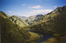
Hells Canyon in 2002
|
|
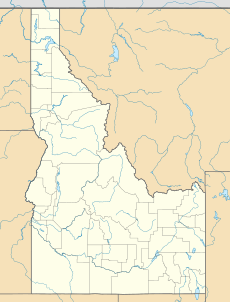
| Location | Oregon & Idaho, U.S. |
| Nearest city | Grangeville, Idaho |
| Area | 652,488 acres (2,641 km2) |
| Established | December 31, 1975 |
| Governing body | U.S. Forest Service |
| Website | Hells Canyon NRA |
Hells Canyon National Recreation Area is a special place in the United States. It sits right on the border between the states of Oregon and Idaho. The U.S. Forest Service takes care of this area. It is part of the Wallowa-Whitman National Forest.
This recreation area was created in 1975 by the U.S. Congress and President Gerald Ford. Its main goal is to protect the amazing history, old archaeological sites, and beautiful nature of Hells Canyon and the Snake River. This includes the part of the Snake River between Hells Canyon Dam and the Oregon–Washington border.
About 215,000 acres (870 km²) of the recreation area is a special protected zone. This zone is called the Hells Canyon Wilderness. There are almost 900 miles (1,400 km) of hiking trails here. Most of the area is in eastern Wallowa County, Oregon. Smaller parts are in southwestern Idaho County, Idaho, northwestern Adams County, Idaho, and northeastern Baker County, Oregon.
The Hells Canyon National Recreation Area was officially opened in 1976. There were ceremonies in June in Idaho and in late July in Oregon.
Hells Canyon Archeological District
|
Hells Canyon Archeological District
|
|
| Area | 12,000 acres (49 km2) |
|---|---|
| NRHP reference No. | 84000984 |
| Added to NRHP | August 10, 1984 |
The Hells Canyon Archeological District is partly or fully inside the Hells Canyon National Recreation Area. It is a historic district that covers 12,000 acres (49 km²). This district is listed on the U.S. National Register of Historic Places.
This district includes 536 important historical sites. It also has 23 old buildings and 58 other structures that tell us about the past.
Many sites here have ancient rock art. These include pictographs, which are pictures painted on rocks. The largest pictograph sites are Buffalo Eddy, with over 500 pictures, and Pittsburg Landing, with nearly 30 boulders covered in them. There is also a special area with a short trail. This trail leads to signs that explain and show petroglyphs (pictures carved into rocks) and pictographs.
Recreation Activities
There are 17 places to camp in the national recreation area. Pittsburg Landing is the only place on the Idaho side where you can camp with an RV. It also has a boat launch for the river. On the Oregon side, there are seven places for RV camping.
Snake River National Recreation Trail
The Snake River National Recreation Trail (SRNRT) is Trail #102. It is located within the Hells Canyon National Recreation Area. This trail runs along the Idaho side of the Snake River. It goes from near Lamont Springs downstream to Pittsburg Landing.
The SRNRT was named a National Recreation Trail in 1980. This happened under the National Trails System Act. The trail was built a long time ago, between the late 1800s and about the 1930s.
You can get to the SRNRT in a few ways. You can drive to the trailhead at Pittsburg Landing, which is at the north end of the trail. Or, you can get there by boat near Hells Canyon Dam, at the south end. You can also reach the trail from the Seven Devils Wilderness Area. This is done through trails from Windy Saddle, which is at an elevation of 7,200 feet (2,200 meters). These trails include the Granite Creek trails or Sheep Creek trails.
 | Dorothy Vaughan |
 | Charles Henry Turner |
 | Hildrus Poindexter |
 | Henry Cecil McBay |


