
Madison County, Montana facts for kids
Quick facts for kids
Madison County
|
|
|---|---|

Madison County Courthouse in Virginia City
|
|

Location within the U.S. state of Montana
|
|
 Montana's location within the U.S. |
|
| Country | |
| State | |
| Founded | 1865 |
| Named for | James Madison |
| Seat | Virginia City |
| Largest town | Ennis |
| Area | |
| • Total | 3,603 sq mi (9,330 km2) |
| • Land | 3,587 sq mi (9,290 km2) |
| • Water | 15 sq mi (40 km2) 0.4% |
| Population
(2020)
|
|
| • Total | 8,623 |
| • Estimate
(2022)
|
9,265 |
| • Density | 2.3933/sq mi (0.92405/km2) |
| Time zone | UTC−7 (Mountain) |
| • Summer (DST) | UTC−6 (MDT) |
| Congressional district | 1st |
|
|
Madison County is a special area, like a big district, located in the state of Montana in the United States. In 2020, about 8,623 people lived here. The main town, or county seat, where the county government is, is called Virginia City. Madison County was created a long time ago in 1865, when Montana was still a territory.
Contents
Exploring Madison County's Geography
Madison County covers a large area. It has a total size of about 3,603 square miles. Most of this area, about 3,587 square miles, is land. Only a small part, about 15 square miles, is water.
Main Roads and Highways
Many important roads help people travel through Madison County. These roads connect different towns and areas.
 Interstate 15
 U.S. Highway 91
 U.S. Highway 287
 Montana Highway 41
 Montana Highway 84
 Montana Highway 87
 Montana Highway 55
 Montana Highway 287
Neighboring Counties
Madison County shares its borders with several other counties. These are like its neighbors.
- Beaverhead County is to the southwest.
- Silver Bow County is to the northwest.
- Jefferson County is to the north.
- Gallatin County is to the east.
- Fremont County, Idaho is to the south.
Protected Natural Areas
Parts of Madison County are home to beautiful national forests. These areas are protected to keep nature safe.
- Beaverhead National Forest (part)
- Deerlodge National Forest (part)
- Gallatin National Forest (part)
People Living in Madison County
The number of people living in Madison County has changed over many years.
| Historical population | |||
|---|---|---|---|
| Census | Pop. | %± | |
| 1870 | 2,684 | — | |
| 1880 | 3,915 | 45.9% | |
| 1890 | 4,692 | 19.8% | |
| 1900 | 7,695 | 64.0% | |
| 1910 | 7,229 | −6.1% | |
| 1920 | 7,495 | 3.7% | |
| 1930 | 6,323 | −15.6% | |
| 1940 | 7,294 | 15.4% | |
| 1950 | 5,998 | −17.8% | |
| 1960 | 5,211 | −13.1% | |
| 1970 | 5,014 | −3.8% | |
| 1980 | 5,448 | 8.7% | |
| 1990 | 5,989 | 9.9% | |
| 2000 | 6,851 | 14.4% | |
| 2010 | 7,691 | 12.3% | |
| 2020 | 8,623 | 12.1% | |
| 2022 (est.) | 9,265 | 20.5% | |
| U.S. Decennial Census 1790–1960 1900–1990 1990–2000 2010–2020 |
|||
Population in 2020
In 2020, a count showed that 8,623 people lived in Madison County.
Population in 2010
In 2010, there were 7,691 people living in the county. Most people were white. A small number were American Indian, Asian, or Black. Some people had mixed backgrounds. About 2.4% of the people were of Hispanic or Latino origin.
Many families lived in the county. The average age of people was about 49.8 years old. The average income for a family was around $52,636 per year.
Towns and Communities
Madison County has several towns and smaller communities. These are places where people live and work.
Main Towns
Other Communities
These are smaller places where people live. Some are called "census-designated places." This means they are recognized for counting people.
- Alder
- Big Sky
- Brandon
- Harrison
- Jeffers
- Mammoth
- McAllister
- Norris
- Pony
- Silver Star
Small Villages and Areas
- Cameron
- Jefferson Island
- Junction
- Laurin
- Nevada City
- Red Bluff
- Rochester
- Ruby
- Sterling
- Summit
Education in Madison County
Madison County has several school districts for kids of all ages. These schools help students learn and grow from kindergarten through high school.
K-12 School Districts
These districts offer schooling from kindergarten to 12th grade.
- Ennis K-12 Schools
- Harrison K-12 Schools
- Twin Bridges K-12 Schools
Some schools are part of larger districts. For example, Sheridan Public Schools has separate parts for elementary and high school.
High School Districts
These districts focus on high school education.
- Sheridan High School District
- Whitehall High School District
Elementary School Districts
These districts focus on elementary school education.
- Alder Elementary School District
- Cardwell Elementary School District
- Sheridan Elementary School District
- Whitehall Elementary School District
Notable People from Madison County
- Sam V. Stewart was an important person from Madison County. He used to be the governor of Montana. He also served as a judge on the state's highest court.
Images for kids
-
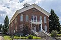
The Madison County Courthouse in Virginia City.
See also
 In Spanish: Condado de Madison (Montana) para niños
