Pony, Montana facts for kids
Quick facts for kids
Pony, Montana
|
|||||||||||||||||||||||||||
|---|---|---|---|---|---|---|---|---|---|---|---|---|---|---|---|---|---|---|---|---|---|---|---|---|---|---|---|

Pony, Montana
|
|||||||||||||||||||||||||||
| Country | |||||||||||||||||||||||||||
| State | |||||||||||||||||||||||||||
| County | Madison | ||||||||||||||||||||||||||
| Area | |||||||||||||||||||||||||||
| • Total | 1.34 sq mi (3.48 km2) | ||||||||||||||||||||||||||
| • Land | 1.34 sq mi (3.48 km2) | ||||||||||||||||||||||||||
| • Water | 0.00 sq mi (0.00 km2) | ||||||||||||||||||||||||||
| Population
(2020)
|
|||||||||||||||||||||||||||
| • Total | 127 | ||||||||||||||||||||||||||
| • Density | 94.63/sq mi (36.54/km2) | ||||||||||||||||||||||||||
| FIPS code | 30-58900 | ||||||||||||||||||||||||||
| GNIS feature ID | 789074 | ||||||||||||||||||||||||||
|
|||||||||||||||||||||||||||
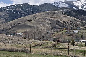
Pony is a small community in Madison County, Montana. It's located on the eastern edge of the Tobacco Root Mountains. In 2020, about 127 people lived here.
Pony is also home to the Pony Historic District. This area covers 192 acres and has 95 important old buildings. It's listed on the National Register of Historic Places, which means it's a special place in American history.
Contents
History of Pony, Montana
How Pony Got Its Name
The town of Pony got its name from an early miner. His name was Tecumseth Smith. People called him "Pony" because he was quite small.
Gold Mining Boom and Decline
Pony was settled in the 1860s. It quickly became a busy place because of gold mining. In the late 1800s, it was a very successful gold-mining town. At one point, more than 5,000 people lived there!
However, the gold mining started to slow down in the early 1900s. By 1922, all the mining operations in Pony had closed.
Preserving Pony's Past
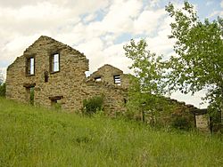
Even though the mines closed, many historic buildings from Pony's busy gold rush days are still standing. A group called the Pony Homecoming Club helps take care of these buildings. They are a non-profit group that works to maintain the town's public spaces.
Geography of Pony
Location and Surroundings
Pony is connected to other towns by roads. Montana Highway 283, also known as Pony Road, links it to U.S. Route 287. This main highway is about 6 miles northeast in a town called Harrison.
The community of Pony covers an area of about 1.34 square miles. All of this area is land. North Willow Creek flows right through the town. This creek then runs northeast and joins the Jefferson River near Three Forks.
Population Changes Over Time
The number of people living in Pony has changed over the years. Here's a look at the population from recent U.S. censuses:
| Historical population | |||
|---|---|---|---|
| Census | Pop. | %± | |
| 2010 | 118 | — | |
| 2020 | 127 | 7.6% | |
| U.S. Decennial Census | |||
Notable People from Pony
Karl Ohs: A Public Servant
Karl Ohs once owned a ranch in Pony. He was an important person in Montana's government. Karl Ohs served as the Lieutenant Governor of Montana. The Lieutenant Governor is like a vice-president for a state. They help the Governor and can take over if needed.
See also
 In Spanish: Pony (Montana) para niños
 | Selma Burke |
 | Pauline Powell Burns |
 | Frederick J. Brown |
 | Robert Blackburn |


