Montana Highway 87 facts for kids
Quick facts for kids
Montana Highway 87 |
||||
|---|---|---|---|---|
|
MT 87 highlighted in red
|
||||
| Route information | ||||
| Maintained by MDT | ||||
| Length | 8.571 mi (13.794 km) | |||
| Existed | October 9, 1922–present | |||
| Major junctions | ||||
| South end | ||||
| North end | ||||
| Location | ||||
| Counties: | Madison | |||
| Highway system | ||||
Montana Highways
|
||||
Montana Highway 87 (MT 87) is an important road in Madison County, Montana. It's a "state highway," which means it's managed by the state government. This road goes through beautiful countryside, including part of the Gallatin National Forest.
MT 87 starts at the border with Idaho and travels north. It ends when it meets U.S. Route 287 (US 287) near Quake Lake. This highway has an interesting history. It became part of Montana's road system way back in 1922. Later, it was quickly improved because another major road nearby had collapsed.
What is Montana Highway 87 Like?
MT 87 begins at the border between Montana and Idaho. It travels through a place called Raynolds Pass. The highway heads north, passing through quiet, rural areas. Soon, it enters the amazing Gallatin National Forest.
As you drive, you'll see several small forest roads connecting to MT 87. The road then turns northwest. It follows a small creek and crosses over the Madison River. After passing a few buildings, the highway continues northwest. It finally ends at a crossing with US 287.
The Montana Department of Transportation (MDT) takes care of MT 87. They also measure how many vehicles use the road. This is called "annual average daily traffic" (AADT). It's like counting how many cars, trucks, and other vehicles use the road each day on average. In 2011, about 583 vehicles used MT 87 every day. This highway is not part of the "National Highway System." That system includes roads that are super important for the country's economy and travel.
How Did Montana Highway 87 Get Here?

The story of MT 87 began on October 9, 1922. That's when a road in this area became part of Montana's official highway system. By 1924, this road was part of a famous "auto trail" called the Banff Grand Canyon Road. Auto trails were like early road maps for cars, helping people find their way across the country.
A year later, the road was improved with a dirt surface. It also became part of another auto trail called the Great White Way. But by 1927, these auto trail names were no longer used for this section of road.
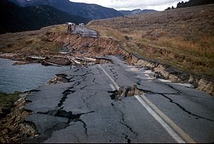
Something big happened in 1959. A powerful earthquake, called the 1959 Hebgen Lake earthquake, caused parts of US 287 to collapse near Hebgen Lake. Because of this, the road where MT 87 is now was quickly improved. It became a very important alternate route for drivers. After US 287 was fixed, the need for this alternate route decreased.
Between 1962 and 1967, most of the highway was rebuilt to be in its current location. By 1987, the road was officially named MT 87. It was also paved, making it much smoother to drive on!
Where Does Montana Highway 87 Connect?
The entire route is in Madison County.
| Location | Mile | Roads intersected | Notes | |
|---|---|---|---|---|
| Raynolds Pass | 0.000 | This is where the highway continues into Idaho. | ||
| Idaho–Montana state line on the Continental Divide | ||||
| | 8.571 | 13.794 | This is the northern end of the highway. | |
| 1.000 mi = 1.609 km; 1.000 km = 0.621 mi | ||||
 | Georgia Louise Harris Brown |
 | Julian Abele |
 | Norma Merrick Sklarek |
 | William Sidney Pittman |


