
Quake Lake facts for kids
Quick facts for kids Quake Lake |
|
|---|---|
 |
|

Quake Lake
Location in Montana
|
|
| Location | Madison / Gallatin counties, Montana, United States |
| Coordinates | 44°51′10″N 111°23′20″W / 44.8528°N 111.3889°W |
| Type | Natural/Fresh Water Lake |
| Primary inflows | Madison River |
| Primary outflows | Madison River |
| Basin countries | United States |
| Max. length | 6 mi (9.7 km) |
| Max. width | .25 mi (0.40 km) |
| Surface area | 611.8 mi (984.6 km) |
| Average depth | 47.2 ft (14.4 m) |
| Max. depth | 124.88 ft (38.06 m) |
| Water volume | 26,555 acre⋅ft (32,755,000 m3) |
| Surface elevation | 6,391 ft (1,948 m) |


Quake Lake, also known as Earthquake Lake, is a lake located in southwestern Montana, United States. It was formed suddenly on August 17, 1959, after a powerful earthquake caused a massive landslide. This natural event sadly led to the loss of 28 lives.
Quake Lake is about 190 feet (58 m) (58 meters) deep and 6 miles (9.7 km) (9.7 kilometers) long. A road called US 287 runs along the lake, allowing visitors to see the lasting effects of the earthquake and landslide. There's also a visitor center nearby where you can learn more. Most of the lake is found within the Gallatin National Forest.
Contents
What Caused Quake Lake?
The Powerful 1959 Earthquake
The earthquake that created Quake Lake was very strong, measuring 7.5 on the Richter scale. Later, experts revised its strength to 7.3. This earthquake caused an enormous landslide of 80 million tons of rock and dirt. This huge slide then blocked the Madison River, forming a natural dam.
This earthquake was the most powerful ever recorded in Montana's history. The landslide rushed down the side of Sheep Mountain at an incredible speed, estimated at 100 miles per hour (160 km/h) (160 km/h). Sadly, 28 people who were camping near Hebgen Lake and along the Madison River lost their lives because of it.
How the Earthquake Changed the Land
The earthquake also caused the ground to crack and shift, creating fault scarps up to 20 ft (6.1 m) (6 meters) high near Hebgen Lake. The bottom of Hebgen Lake itself dropped by the same amount. About 32,000 acres (130 km2) (130 square kilometers) of land near Hebgen Lake sank more than 10 ft (3.0 m) (3 meters).
The shaking even affected Yellowstone National Park, which is nearby. Some geysers in the park erupted, and many hot springs became muddy for a short time.
Damage and Aftershocks
In the area closest to the earthquake and landslide, some cabins and homes were destroyed. However, the overall damage to buildings and roads was not as widespread as it could have been. The total cost of damage in 1959 was about 11 million dollars.
After the main earthquake, smaller quakes called aftershocks continued for several months. Some of these aftershocks were as strong as 6.5 on the Richter scale. At the time, this earthquake was the second largest to happen in the continental U.S. during the 20th century.
How Hebgen Dam Survived and the Lake Formed
Hebgen Dam, which was built in 1917, is made of concrete and rock. It was badly damaged by the earthquake but managed to stay in place. Repairs to the dam's spillway (a channel for water to flow over) were finished in just a few weeks.
The massive landslide happened downstream from the dam. It blocked almost all the water flow of the Madison River. The river's water then began to fill up the area behind the landslide, creating a new lake. In less than a month, this new body of water became what we now call Quake Lake.
Because this new lake didn't have a natural way for its water to flow out safely, the U.S. Army Corps of Engineers had to act quickly. They launched one of their largest operations ever in the western U.S. To prevent the new natural dam from breaking due to the rising water, they built a special spillway. This helped control the water flow and reduce the risk of the natural dam eroding or failing.
Visiting Quake Lake: The Visitor Center
.jpg)
In 1967, the U.S. Forest Service opened the Earthquake Lake Visitor Center. Each year, more than 50,000 people visit this center.
From the visitor center, you can see a wide view of the mountain that collapsed and the lake that was formed. The center has displays that explain earthquakes, how Earth's plates move (plate tectonics), and even a working seismograph, which is a device that measures ground motion. The center is located in the Custer Gallatin National Forest.
Images for kids
-
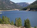
Quake Lake
-
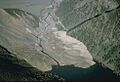
Landslide at Quake Lake
-
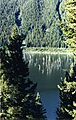
Quake Lake from overlook
-
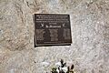
Memorial for the victims from the 1959 earthquake at the Earthquake Lake Visitor Center
See also
 In Spanish: Lago Quake para niños
