
West Yellowstone, Montana facts for kids
Quick facts for kids
West Yellowstone
|
||
|---|---|---|

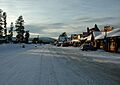
Yellowstone Avenue in winter
|
||
|
||

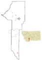
Location of West Yellowstone within Gallatin County
|
||
| Country | ||
| State | ||
| County | Gallatin | |
| Area | ||
| • Total | 0.91 sq mi (2.35 km2) | |
| • Land | 0.91 sq mi (2.35 km2) | |
| • Water | 0.00 sq mi (0.00 km2) | |
| Elevation | 6,667 ft (2,032 m) | |
| Population
(2020)
|
||
| • Total | 1,272 | |
| • Density | 1,400.88/sq mi (541.10/km2) | |
| Time zone | UTC-7 (Mountain) | |
| • Summer (DST) | UTC-6 (Mountain) | |
| ZIP Code |
59758
|
|
| Area code(s) | 406 | |
| FIPS code | 30-79525 | |
| GNIS ID | 2413469 | |

West Yellowstone is a small town in Montana, United States. It is located right next to the famous Yellowstone National Park. In 2020, about 1,272 people lived there. The town has its own airport, called Yellowstone Airport.
West Yellowstone is a popular spot for visitors to Yellowstone National Park. It has many places to stay, gift shops, and other services for travelers.
Contents
- Town History: How West Yellowstone Began
- Geography: Where West Yellowstone Is Located
- Population: Who Lives in West Yellowstone?
- Economy: How West Yellowstone Makes Money
- Education: Schools and Learning in Town
- Media: Radio Stations in West Yellowstone
- Infrastructure: Town Layout and Travel
- Images for kids
- See also
Town History: How West Yellowstone Began
West Yellowstone was started in June 1908. This happened when the Oregon Short Line Railroad finished building its train tracks to the area.
The town's name changed a few times. Finally, in 1920, everyone agreed on "West Yellowstone." Train service to the town stopped in 1960. The town officially became a town (incorporated) in 1966.
Geography: Where West Yellowstone Is Located
West Yellowstone is a small town, covering about 0.91 square miles (2.35 square kilometers). All of this area is land.
Climate: Weather in West Yellowstone
West Yellowstone is very high up, about 6,660 feet (2,030 meters) above sea level. It is also nearly halfway between the equator and the North Pole. Because of this, it has a subarctic climate. This means winters are very cold, sometimes extremely cold. Summers are short but usually warm.
The town is covered in snow from early November until early May. In March, the snow can be 3.5 to 4 feet deep. In 2007–2008, snow was on the ground from late October until mid-May. It reached 4.5 feet deep by late March.
During summer, the average low temperature is about 41°F (5°C). The average high is around 78°F (26°C). In January, the coldest month, the average low is 0°F (-18°C). The average high is 24°F (-4°C).
West Yellowstone holds a record for the coldest temperature ever recorded in a town in the contiguous United States. It was -66°F (-54°C). However, an even colder temperature of -70°F (-57°C) was once recorded at Rogers Pass, Montana.
| Climate data for West Yellowstone, Montana 1991–2020 normals, 1924-2020 extremes: 6679ft (2036m) | |||||||||||||
|---|---|---|---|---|---|---|---|---|---|---|---|---|---|
| Month | Jan | Feb | Mar | Apr | May | Jun | Jul | Aug | Sep | Oct | Nov | Dec | Year |
| Record high °F (°C) | 47 (8) |
56 (13) |
61 (16) |
76 (24) |
88 (31) |
93 (34) |
99 (37) |
96 (36) |
91 (33) |
83 (28) |
64 (18) |
54 (12) |
99 (37) |
| Mean maximum °F (°C) | 38.1 (3.4) |
42.2 (5.7) |
53.8 (12.1) |
65.8 (18.8) |
74.9 (23.8) |
84.5 (29.2) |
88.6 (31.4) |
88.4 (31.3) |
83.3 (28.5) |
69.1 (20.6) |
53.6 (12.0) |
38.3 (3.5) |
89.6 (32.0) |
| Mean daily maximum °F (°C) | 26.8 (−2.9) |
31.2 (−0.4) |
39.7 (4.3) |
47.7 (8.7) |
59.2 (15.1) |
68.4 (20.2) |
79.7 (26.5) |
77.9 (25.5) |
67.6 (19.8) |
50.8 (10.4) |
35.9 (2.2) |
25.8 (−3.4) |
50.9 (10.5) |
| Daily mean °F (°C) | 13.5 (−10.3) |
16.4 (−8.7) |
24.4 (−4.2) |
34.2 (1.2) |
43.9 (6.6) |
51.2 (10.7) |
59.4 (15.2) |
57.0 (13.9) |
48.6 (9.2) |
36.1 (2.3) |
23.6 (−4.7) |
14.2 (−9.9) |
35.2 (1.8) |
| Mean daily minimum °F (°C) | 0.2 (−17.7) |
1.5 (−16.9) |
9.1 (−12.7) |
20.7 (−6.3) |
28.5 (−1.9) |
33.9 (1.1) |
39.2 (4.0) |
36.2 (2.3) |
29.6 (−1.3) |
21.4 (−5.9) |
11.4 (−11.4) |
2.7 (−16.3) |
19.5 (−6.9) |
| Mean minimum °F (°C) | −27.8 (−33.2) |
−28.0 (−33.3) |
−13.4 (−25.2) |
3.4 (−15.9) |
16.6 (−8.6) |
25.2 (−3.8) |
28.6 (−1.9) |
26.4 (−3.1) |
20.1 (−6.6) |
5.5 (−14.7) |
−13.8 (−25.4) |
−28.0 (−33.3) |
−34.5 (−36.9) |
| Record low °F (°C) | −60 (−51) |
−66 (−54) |
−43 (−42) |
−26 (−32) |
0 (−18) |
18 (−8) |
20 (−7) |
15 (−9) |
−9 (−23) |
−20 (−29) |
−38 (−39) |
−59 (−51) |
−66 (−54) |
| Average precipitation inches (mm) | 2.28 (58) |
2.06 (52) |
2.17 (55) |
2.31 (59) |
2.70 (69) |
2.49 (63) |
1.30 (33) |
1.39 (35) |
1.69 (43) |
1.92 (49) |
2.61 (66) |
3.05 (77) |
25.97 (659) |
| Average snowfall inches (cm) | 26.6 (68) |
23.2 (59) |
16.6 (42) |
11.2 (28) |
1.8 (4.6) |
0.2 (0.51) |
0.0 (0.0) |
0.0 (0.0) |
0.6 (1.5) |
3.9 (9.9) |
19.7 (50) |
31.3 (80) |
135.1 (343.51) |
| Source 1: NOAA | |||||||||||||
| Source 2: XMACIS2 (2008-2020 snowfall) | |||||||||||||
| Climate data for West Yellowstone | |||||||||||||
|---|---|---|---|---|---|---|---|---|---|---|---|---|---|
| Month | Jan | Feb | Mar | Apr | May | Jun | Jul | Aug | Sep | Oct | Nov | Dec | Year |
| Record high °F (°C) | 47 (8) |
56 (13) |
61 (16) |
76 (24) |
88 (31) |
93 (34) |
97 (36) |
96 (36) |
91 (33) |
83 (28) |
64 (18) |
54 (12) |
97 (36) |
| Mean daily maximum °F (°C) | 24.1 (−4.4) |
30.5 (−0.8) |
38.0 (3.3) |
47.6 (8.7) |
58.7 (14.8) |
68.5 (20.3) |
78.8 (26.0) |
77.2 (25.1) |
66.4 (19.1) |
52.3 (11.3) |
33.8 (1.0) |
24.1 (−4.4) |
50.3 (10.2) |
| Daily mean °F (°C) | 12 (−11) |
16.5 (−8.6) |
23.4 (−4.8) |
33.7 (0.9) |
43.7 (6.5) |
51.9 (11.1) |
59.2 (15.1) |
57.2 (14.0) |
47.9 (8.8) |
37.2 (2.9) |
22.1 (−5.5) |
12.6 (−10.8) |
34.8 (1.5) |
| Mean daily minimum °F (°C) | −0.2 (−17.9) |
2.5 (−16.4) |
8.7 (−12.9) |
19.7 (−6.8) |
28.7 (−1.8) |
35.3 (1.8) |
39.6 (4.2) |
37.2 (2.9) |
29.4 (−1.4) |
22.1 (−5.5) |
10.3 (−12.1) |
1.0 (−17.2) |
19.6 (−6.9) |
| Record low °F (°C) | −63 (−53) |
−66 (−54) |
−43 (−42) |
−26 (−32) |
−4 (−20) |
18 (−8) |
20 (−7) |
15 (−9) |
−9 (−23) |
−20 (−29) |
−38 (−39) |
−59 (−51) |
−66 (−54) |
| Average precipitation inches (mm) | 1.96 (50) |
1.77 (45) |
1.87 (47) |
1.51 (38) |
2.19 (56) |
2.21 (56) |
1.84 (47) |
1.36 (35) |
1.47 (37) |
1.30 (33) |
2.01 (51) |
2.30 (58) |
21.79 (553) |
| Average snowfall inches (cm) | 32.9 (84) |
26.6 (68) |
23.3 (59) |
20.7 (53) |
3.3 (8.4) |
0.6 (1.5) |
0.0 (0.0) |
0.1 (0.25) |
1.2 (3.0) |
7.3 (19) |
22.9 (58) |
31.4 (80) |
170.3 (434.15) |
| Average precipitation days (≥ 1.0 mm) | 7.6 | 5.8 | 4.2 | 4.0 | 5.5 | 4.6 | 5.6 | 4.5 | 4.9 | 5.3 | 4.4 | 4.7 | 61.1 |
| Source 1: Weatherbase and WRCC (snow only) | |||||||||||||
| Source 2: Infoclimat.fr (average days with precipitation) | |||||||||||||
Population: Who Lives in West Yellowstone?
| Historical population | |||
|---|---|---|---|
| Census | Pop. | %± | |
| 1930 | 200 | — | |
| 1940 | 300 | 50.0% | |
| 1950 | 400 | 33.3% | |
| 1960 | 500 | 25.0% | |
| 1970 | 756 | 51.2% | |
| 1980 | 735 | −2.8% | |
| 1990 | 913 | 24.2% | |
| 2000 | 1,177 | 28.9% | |
| 2010 | 1,271 | 8.0% | |
| 2020 | 1,272 | 0.1% | |
| source: U.S. Decennial Census | |||
In 2010, there were 1,271 people living in West Yellowstone. They lived in 617 households. The town had 969 housing units.
Most people in the town (86.6%) were White. About 17.9% of the population were Hispanic or Latino.
About 23.7% of homes had children under 18 living there. The average household had 2.06 people. The average family had 2.86 people.
The average age in town was 39.4 years old. About 20.9% of residents were under 18. About 8.4% were 65 or older. There were slightly more males (53.1%) than females (46.9%).
Economy: How West Yellowstone Makes Money

Tourism: A Big Part of the Economy
West Yellowstone gets a lot of visitors because it's so close to Yellowstone National Park. Many tourists come from places like China. To help these visitors, the town has signs in Mandarin. It also has six Chinese restaurants. It's thought that more than half of the town's yearly business comes from Chinese tourists.
Education: Schools and Learning in Town
West Yellowstone has its own school district for kindergarten through 12th grade.
The town has one school, the West Yellowstone School. It teaches students from kindergarten all the way to 12th grade. West Yellowstone High School is a small school. Its sports teams are called the Wolverines.
The West Yellowstone Public Library serves the people living in the area.
Media: Radio Stations in West Yellowstone
Three radio stations broadcast from West Yellowstone.
- KWYS (AM) plays oldies music.
- KEZQ plays soft adult contemporary music.
- KPWY is a religious radio station.
Infrastructure: Town Layout and Travel
Town Layout: How the Town is Organized
The D Parkway road generally divides the town. South of D Parkway is mostly for businesses and shops. North of D Parkway is where most homes and apartments are. Locals call the area north of D Parkway the "Madison Addition."
Transportation: Getting Around West Yellowstone
The West Yellowstone Airport is located north of town. It mainly operates during the summer months.
Two main roads, U.S. Route 20 and U.S. Route 191, go through the town.
In the past, trains used to come to West Yellowstone. The Union Pacific Railroad ran trains like the Butte Special and the Yellowstone Special. These trains brought people to the town. Train service ended in 1971.
Images for kids
-
Yellowstone Avenue in winter
-
Town of West Yellowstone Seal
-
Location of West Yellowstone within Gallatin County
-
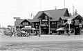
Eagle's store in West Yellowstone, 1939
See also
 In Spanish: West Yellowstone (Montana) para niños
