
Ennis, Montana facts for kids
Quick facts for kids
Ennis, Montana
|
|
|---|---|

Main Street
|
|

Location in Madison County and the state of Montana
|
|

Ennis, Montana
Location in Montana

Ennis, Montana
Location in the United States
|
|
| Country | |
| State | |
| County | Madison |
| Area | |
| • Total | 0.74 sq mi (1.92 km2) |
| • Land | 0.74 sq mi (1.91 km2) |
| • Water | 0.00 sq mi (0.00 km2) |
| Elevation | 4,941 ft (1,506 m) |
| Population
(2020)
|
|
| • Total | 917 |
| • Density | 1,242.55/sq mi (479.52/km2) |
| Time zone | UTC-7 (Mountain (MST)) |
| • Summer (DST) | UTC-6 (MDT) |
| ZIP code |
59729
|
| Area code(s) | 406 |
| FIPS code | 30-24475 |
| GNIS feature ID | 783212 |
Ennis is a small town in Madison County, Montana, in the southwestern part of the state. It's located in the United States. In 2020, about 917 people lived there. This was a bit more than the 838 people counted in 2010.
U.S. Route 287 goes right through Ennis. This road follows the Madison River as it flows down from the town of West Yellowstone.
Contents
History of Ennis

In 1863, people found gold in a place called Alder Gulch. This discovery led to a "gold rush" where many people came looking for riches. Just two months later, a man named William Ennis settled on land along the Madison River. This spot soon grew into the town we know today as Ennis, named after him.
In 1886, people in the Madison Valley noticed a strange animal. It was attacking and killing farm animals. A local rancher, Israel Ammon Hutchins, eventually shot and killed the creature. A taxidermist preserved the animal. Later, around 2007, Hutchins' grandson, Jack Kirby, found the preserved animal at a museum in Pocatello, Idaho.
The company Avid Aircraft, which made planes for people to build at home, used to be located in Ennis. The company stopped making planes in 2003.
The Thexton Ranch is a historic place about 7 miles (11 km) south of Ennis. It is listed on the National Register of Historic Places. This means it's an important site for history.
Geography of Ennis
Ennis is surrounded by beautiful mountains. To the northwest are the Tobacco Root Mountains. To the southwest, you'll find the Gravelly Range. And to the east are the Madison Range mountains. About 12 miles (19 km) north of town, the Madison Dam creates Ennis Lake. This lake is at the start of Bear Trap Canyon.
You can see a large letter "E" placed on a hill west of the town. It's a local landmark!
The town covers about 0.74 square miles (1.92 square kilometers). Most of this area is land, with only a tiny bit of water. The Madison River, which is one of the main rivers that form the Missouri River, flows along the eastern edge of Ennis.
Climate in Ennis
Ennis has a climate with warm summers. This means it gets warm in the summer, but it also has cold winters.
| Climate data for Ennis, Montana, 1991–2020 normals, extremes 1918–present | |||||||||||||
|---|---|---|---|---|---|---|---|---|---|---|---|---|---|
| Month | Jan | Feb | Mar | Apr | May | Jun | Jul | Aug | Sep | Oct | Nov | Dec | Year |
| Record high °F (°C) | 61 (16) |
65 (18) |
76 (24) |
85 (29) |
94 (34) |
99 (37) |
100 (38) |
101 (38) |
98 (37) |
90 (32) |
72 (22) |
68 (20) |
101 (38) |
| Mean maximum °F (°C) | 50.6 (10.3) |
53.8 (12.1) |
63.9 (17.7) |
73.9 (23.3) |
81.9 (27.7) |
88.4 (31.3) |
93.7 (34.3) |
93.0 (33.9) |
88.7 (31.5) |
77.9 (25.5) |
63.1 (17.3) |
50.1 (10.1) |
95.0 (35.0) |
| Mean daily maximum °F (°C) | 34.0 (1.1) |
37.1 (2.8) |
46.4 (8.0) |
54.6 (12.6) |
64.1 (17.8) |
72.6 (22.6) |
82.8 (28.2) |
82.1 (27.8) |
72.2 (22.3) |
57.6 (14.2) |
42.7 (5.9) |
33.2 (0.7) |
56.6 (13.7) |
| Daily mean °F (°C) | 24.6 (−4.1) |
26.2 (−3.2) |
34.0 (1.1) |
41.1 (5.1) |
49.4 (9.7) |
56.7 (13.7) |
64.2 (17.9) |
62.8 (17.1) |
54.6 (12.6) |
43.3 (6.3) |
32.1 (0.1) |
23.8 (−4.6) |
42.7 (6.0) |
| Mean daily minimum °F (°C) | 15.1 (−9.4) |
15.3 (−9.3) |
21.7 (−5.7) |
27.6 (−2.4) |
34.7 (1.5) |
40.7 (4.8) |
45.5 (7.5) |
43.6 (6.4) |
37.1 (2.8) |
29.0 (−1.7) |
21.6 (−5.8) |
14.5 (−9.7) |
28.9 (−1.7) |
| Mean minimum °F (°C) | −10.0 (−23.3) |
−8.3 (−22.4) |
3.3 (−15.9) |
14.2 (−9.9) |
21.9 (−5.6) |
31.0 (−0.6) |
37.4 (3.0) |
35.0 (1.7) |
25.5 (−3.6) |
11.2 (−11.6) |
−2.0 (−18.9) |
−9.3 (−22.9) |
−20.0 (−28.9) |
| Record low °F (°C) | −43 (−42) |
−43 (−42) |
−34 (−37) |
−7 (−22) |
12 (−11) |
24 (−4) |
29 (−2) |
27 (−3) |
10 (−12) |
−12 (−24) |
−27 (−33) |
−35 (−37) |
−43 (−42) |
| Average precipitation inches (mm) | 0.45 (11) |
0.51 (13) |
0.84 (21) |
1.47 (37) |
1.93 (49) |
2.23 (57) |
1.16 (29) |
1.02 (26) |
0.97 (25) |
1.14 (29) |
0.69 (18) |
0.54 (14) |
12.95 (329) |
| Average snowfall inches (cm) | 6.5 (17) |
7.6 (19) |
6.6 (17) |
6.0 (15) |
1.3 (3.3) |
0.2 (0.51) |
0.0 (0.0) |
0.0 (0.0) |
0.1 (0.25) |
2.2 (5.6) |
6.9 (18) |
7.3 (19) |
44.7 (114.66) |
| Average precipitation days (≥ 0.01 in) | 5.3 | 5.9 | 7.7 | 10.7 | 11.8 | 11.1 | 8.2 | 6.6 | 6.6 | 7.8 | 6.6 | 5.9 | 94.2 |
| Average snowy days (≥ 0.1 in) | 4.3 | 4.4 | 4.2 | 3.3 | 0.8 | 0.0 | 0.0 | 0.0 | 0.1 | 1.5 | 3.6 | 5.0 | 27.2 |
| Source 1: NOAA | |||||||||||||
| Source 2: National Weather Service | |||||||||||||
Population of Ennis
| Historical population | |||
|---|---|---|---|
| Census | Pop. | %± | |
| 1960 | 525 | — | |
| 1970 | 501 | −4.6% | |
| 1980 | 660 | 31.7% | |
| 1990 | 773 | 17.1% | |
| 2000 | 840 | 8.7% | |
| 2010 | 838 | −0.2% | |
| 2020 | 917 | 9.4% | |
| U.S. Decennial Census | |||
2010 Census Details
In 2010, the census showed that 838 people lived in Ennis. There were 416 households. Many people lived alone, and about 20% of households had children under 18. The average age of people in Ennis was about 49.8 years old.
Economy in Ennis
Ennis is a hub for ranching in the Madison River valley. You'll see large ranches with cattle and sheep both north and south of the town along the river.
Ennis is also a popular spot for tourists. Many people come here for fly fishing. They try to catch rainbow and brown trout in the Madison River. The town has several fishing shops and resorts that offer guided fishing trips. You can also fish in nearby Yellowstone National Park.
Ennis is home to Willie's Distillery, which makes bourbon and moonshine. It's one of the many small distilleries growing in Montana.
Arts and Culture in Ennis

Ennis has a public library called the Madison Valley Public Library. It's a great place to find books and learn new things.
Annual Events in Ennis
- Ennis has a fun annual July 4th parade, which also includes a rodeo event.
- The Ennis on the Madison Fly Fishing Festival happens every August.
- The Madison Trifecta is a duathlon (a race with two sports) held on the 4th of July weekend. It takes place between Ennis and Virginia City, Montana.
- A full marathon, which is a very long running race, is held in July. It's one of the highest elevation runs in the United States, going over 9,000 feet (2,743 meters)!
- The Madison Triathlon (a race with three sports) is held in August between Ennis and Harrison, Montana.
- In October, the annual Hunters Feed takes place the day before rifle hunting season begins.
- Tap Into Ennis is Montana's first festival that combines breweries and distilleries. It also features artists and local music.
- Ennis also hosts the Madison Valley Arts Festival, celebrating local art.
Education in Ennis
Students in Ennis attend schools within the Ennis K-12 Schools district. This district teaches students from kindergarten all the way through 12th grade. The sports teams at Ennis High School are called the Mustangs.
Media in Ennis
The Madisonian is a newspaper that serves Madison County. It is printed once a week and also has an online version.
Infrastructure in Ennis
Ennis is located on U.S. Highway 287 and Montana Highway 287. These are important roads for getting around.
The town is served by the Big Sky Airport. The closest airport where you can catch regular commercial flights is Bozeman Yellowstone International Airport. This airport is about 54 miles (87 km) away.
The Madison Valley Medical Center provides healthcare services to the people living in Ennis and the surrounding community.
Images for kids
-
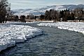
Madison River at Ennis in January
See also
 In Spanish: Ennis (Montana) para niños
