
National Register of Historic Places listings in Madison County, Montana facts for kids

Imagine a special list of important places in the United States! This list is called the National Register of Historic Places. It helps protect buildings, sites, and objects that are important to American history. In Madison County, Montana, there are 18 places on this list. One of them is even more special and is called a National Historic Landmark.
This article will tell you about some of these amazing historic spots in Madison County, Montana. These places help us learn about the past and understand how people lived long ago.
Contents
Exploring Madison County's Historic Treasures
Madison County, Montana, is full of history, from old mining towns to important natural landmarks. Let's discover some of the places that are recognized for their special past.
Beaverhead Rock: A Landmark for Explorers

One of the most famous spots is Beaverhead Rock. This large rock formation is about 14 miles northeast of Dillon, Montana. It was a very important landmark for the Lewis and Clark Expedition in 1805. The Shoshone people, including Sacagawea, recognized this rock. It looked like a swimming beaver's head, and it told them they were close to the Shoshone lands. This helped the expedition find the help they needed to continue their journey west.
Historic Homes and Churches
Many old buildings in Madison County tell stories of the people who lived there.
Dr. Don L. Byam House

In Nevada City, Montana, you can find the Dr. Don L. Byam House on Main Street. This house was built a long time ago and shows us how homes looked in the early 1900s. It's a great example of the architecture from that time.
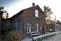
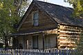
Finney House
Also in Nevada City, at the corner of Main and California Streets, is the Finney House.

Like the Byam House, it's a well-preserved building that gives us a peek into the daily lives of early residents in this historic mining town.
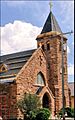
Christ Episcopal Church and Rectory

In Sheridan, Montana, the Christ Episcopal Church and Rectory stands at 304 S. Main Street. This beautiful church and its rectory (the minister's house) were built in the late 1800s. They show the importance of community and faith in the early settlements of Montana.
Saint Mary of the Assumption Church
.jpg)
Off Montana Highway 287 in Laurin, Montana, is the Saint Mary of the Assumption Church. This church, built in 1885, is a significant part of the area's history. It served as a spiritual center for the community for many years.
Unique Structures and Districts
Some places are special because of their unique design or because they represent a whole area with a shared history.
Doncaster Round Barn

Near Twin Bridges, Montana, you can see the Doncaster Round Barn on Riverside Drive. This barn is unusual because it's round! Round barns were sometimes built for efficiency in farming, making it easier to feed animals or store hay. This one is a rare and interesting example of its kind.
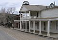
Pony Historic District

The community of Pony, Montana, southwest of Harrison, is recognized as the Pony Historic District. This means that many buildings and the overall layout of the town are historically important. Pony was once a busy mining town, and its historic district helps preserve the story of its gold and silver mining past.
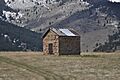
Powder House

Also near Pony, about half a mile southeast on Potosi Road, is the Powder House. This small building was used to store explosives (powder) safely for the nearby mines. It's a reminder of the dangerous but vital work done in the mining industry.
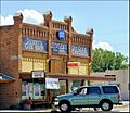
Virginia City Historic District

Perhaps one of the most famous historic places in Madison County is the Virginia City Historic District on Wallace Street in Virginia City, Montana. This entire town is a National Historic Landmark! Virginia City was a booming gold rush town in the 1860s. Today, it's incredibly well-preserved, almost like a living museum. You can walk its streets and imagine what life was like during the gold rush era.
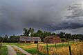
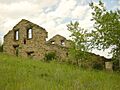
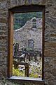
Union City

Southeast of Virginia City are the remains of Union City, an abandoned mining camp. This site offers a glimpse into the many smaller settlements that sprang up and then faded away as mining fortunes changed.
Other Important Sites
Many other places contribute to Madison County's rich history.
Hutchins Bridge
The Hutchins Bridge crosses the Madison River near Cameron, Montana. This bridge is an important example of early engineering and transportation in the region.
Madison County Fairgrounds
The Madison County Fairgrounds on Montana Highway 41 in Twin Bridges has been a gathering place for the community for many years. Fairs are a long-standing tradition, bringing people together for fun, agriculture, and local events.
Robbers Roost
About 5 miles north of Alder, Montana, at Montana Highway 387A, is a place called Robbers Roost. This site has a colorful history, often associated with outlaws and stagecoach robberies during the wild west days.
Strawberry Mine Historic District
Near Pony, the Strawberry Mine Historic District covers an area roughly bounded by Strawberry Ridge, Pony Road, and Pony Creek. This district preserves the history of the Strawberry Mine, another important mining operation in the area.
Thexton Ranch
The Thexton Ranch at 335 Varney Road in Ennis, Montana, is a historic ranch property. Ranches played a huge role in Montana's development, providing food and contributing to the state's economy and culture.
These historic places in Madison County help us connect with the past and understand the amazing stories of Montana's pioneers, miners, and communities. They are important reminders of where we came from and how our world was shaped.
Images for kids
-
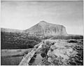
Beaverhead Rock, a key landmark for the Lewis and Clark Expedition.
-
The Dr. Don L. Byam House in Nevada City.
-
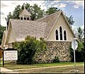
Christ Episcopal Church in Sheridan, Montana.
-
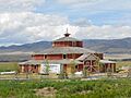
The unique Doncaster Round Barn near Twin Bridges.
-
Ferris-Hermsmeyer-Fenton property.
-
The historic Finney House in Nevada City.
-
The mill at Pony, Montana, part of the historic district.
-
The Powder House near Pony, Montana.
-
The H.D. Rossiter Building in Sheridan.
-
Saint Mary of the Assumption Church in Laurin.
-
The remains of Union City, an abandoned mining camp.
-
Historic buildings in Virginia City, Montana.


