
Bridger Range facts for kids
Quick facts for kids Bridger Range |
|
|---|---|

West face of the Bridger Range
|
|
| Highest point | |
| Peak | Sacagawea Peak |
| Elevation | 9,596 ft (2,925 m) |
| Geography | |

Location within the state of Montana
|
|
| Country | United States |
| State | Montana |
| Range coordinates | 45°53.3′N 110°57.5′W / 45.8883°N 110.9583°W |
| Parent range | Rocky Mountains |
The Bridger Range, also known as the Bridger Mountains, is a cool mountain range in southwestern Montana, United States. It's part of the larger Rocky Mountains. These mountains stretch mostly from north to south, sitting between the towns of Bozeman and Maudlow.
The Bridger Range is separated from other mountain areas by different natural features. To the south, Bozeman Pass separates it from the Gallatin Range. Dry Creek is to the west, separating it from the Horseshoe Hills. The Shields River valley is to the east, next to the Crazy Mountains. And to the north, Sixteen Mile Creek separates it from the Big Belt Mountains.
The tallest point in the Bridger Range is Sacagawea Peak. It stands at 9,596 feet (2,925 m) high! You can easily see this peak from Bozeman, looking towards the northeast. Most of the range is in Gallatin County, but a small part reaches into Park County. The entire Bridger Range is located within the Gallatin National Forest, which is a protected area.
Contents
History of the Bridger Mountains
The Bridger Range got its name from a famous person named Jim Bridger. He was a "mountain man" in the 1800s. A mountain man was an explorer and fur trapper who lived in the wilderness. Jim Bridger was known for finding new paths through the mountains. In 1864, he pioneered a trail called the Bridger Trail through mountains in southern Wyoming.
Tallest Peaks in the Bridger Range
The Bridger Range has several impressive peaks. Here are some of the most well-known ones:
- Sacagawea Peak, 45°53′44″N 110°58′08″W / 45.89556°N 110.96889°W, 9,596 feet (2,925 m)
- Hardscrabble Peak, 45°54′52″N 110°58′57″W / 45.91444°N 110.98250°W, 9,527 feet (2,904 m)
- Naya Nuki Peak, 45°53′30″N 110°57′43″W / 45.89167°N 110.96194°W, 9,449 feet (2,880 m)
- Saddle Peak, 45°47′37″N 110°56′12″W / 45.79361°N 110.93667°W, 9,134 feet (2,784 m)
- Ross Peak, 45°51′31″N 110°57′22″W / 45.85861°N 110.95611°W, 9,012 feet (2,747 m)
- Mount Baldy, 45°44′00″N 110°57′33″W / 45.73333°N 110.95917°W, 7,106 feet (2,166 m)
- Bridger Peak, 45°46′46″N 110°56′20″W / 45.77944°N 110.93889°W, 8,583 feet (2,616 m)
Fun Things to Do in the Bridgers
The Bridger Range is a great place for outdoor activities, especially skiing and hiking!
Skiing Adventures
The Bridger Range is home to a popular ski area called Bridger Bowl. It started with its first rope tow in 1951 and quickly became a favorite spot for local skiers and snowboarders. The top of the ski area is 8,700 feet high, and the base is at 6,100 feet. On average, Bridger Bowl gets about 350 inches (890 cm) of snow every year, which is a lot!
Backcountry skiing is also very popular here. This means skiing in wild, ungroomed areas outside of the main ski resort. You can find snow on peaks like Sacagawea from early November all the way until late May or early June. Since the 2008–2009 ski season, Bridger Bowl has allowed people to access backcountry areas from special gates at the edges of the ski resort.
Hiking Trails
There are many hiking trails in the Bridger Mountains, but one of the most popular is the hike to Sacagawea Peak. This hike is a bit tough but totally worth it! It's about 2.2-mile (3.5 km) one-way. You'll walk through pine forests, open alpine tundra areas, and even across rocky scree fields to reach the top of Sacagawea Peak.
Another exciting event is the Bridger Ridge Run. This is a 20-mile (32 km) race that happens every year in mid-August. Runners follow the long ridgeline of the mountains, starting from Fairy Lake and going all the way to the southern end of the range. It's a challenging and beautiful race!
Images for kids
-
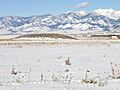
Bridger Range as seen from Bozeman, January 2009
-
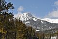
Ross Peak, Bridger Range, April 2010
-
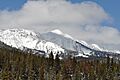
Sacagawea Peak (right) and Naya Nuki Peak (left), April 2010
-
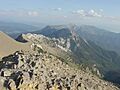
View of the Bridger Range looking south from the summit of Sacagawea Peak


