Sacagawea Peak facts for kids
Quick facts for kids Sacagawea Peak |
|
|---|---|

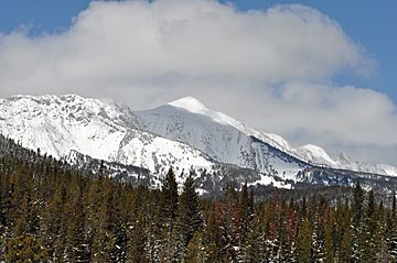
Sacagawea Peak viewed from the south-east.
|
|
| Highest point | |
| Elevation | 9,654 ft (2,943 m) |
| Prominence | 3,930 ft (1,200 m) |
| Geography | |
| Location | Gallatin County, Montana, U.S. |
| Parent range | Bridger Range |
| Topo map | USGS Sacagawea Peak |
| Climbing | |
| Easiest route | Hike |
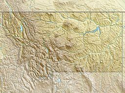
Sacagawea Peak is the tallest mountain in the Bridger Range. This mountain range is located in the southwestern part of Montana, a state in the United States. The peak stands at an impressive 9,654 feet (2,943 meters) above sea level.
The mountain is named after Sacagawea. She was a brave Lemhi Shoshone woman. Sacagawea played a very important role in the famous Lewis and Clark Expedition. She helped them explore the western parts of North America.
Exploring Sacagawea Peak
Sacagawea Peak is a very popular spot for outdoor activities. Many people enjoy visiting this mountain, especially for hiking and skiing. It offers amazing views and a chance to experience nature.
Hiking Adventures
Hiking to the top of Sacagawea Peak is a favorite activity. The main path, called a trailhead, starts at 7,788 feet high. From there, hikers climb about 1,800 feet to reach the summit. The hike to the very top is about 2 miles long. It's a great way to get exercise and see beautiful scenery.
Skiing Fun
Even in the warmer months, Sacagawea Peak often has snow. Snow can stay in its deep valleys, called chutes, through the early summer. Because of this, local skiers love to visit. They can often ski on the mountain even as late as August! This makes it a unique place for skiing outside of the usual winter season.
 | Roy Wilkins |
 | John Lewis |
 | Linda Carol Brown |


