
Bozeman Pass facts for kids
Quick facts for kids Bozeman Pass |
|
|---|---|

Historical marker placed at Bozeman Pass on Interstate 90.
|
|
| Elevation | 5,702 ft (1,738 m) |
| Traversed by | Interstate 90 and Montana Rail Link |
| Location | Gallatin County, Montana, United States |
| Range | Gallatin Range |
| Coordinates | 45°40′02″N 110°48′28″W / 45.66722°N 110.80778°W |
Bozeman Pass is a mountain pass in Montana, about 13 miles (21 km) east of Bozeman, Montana and 15 miles (24 km) west of Livingston, Montana. It sits at an elevation of 5,702 feet (1,738 m) (about 1.7 kilometers high!). This pass is an important route for Interstate 90, a major highway, and also for trains. It separates two large groups of mountains: the Bridger Range and the Gallatin Range.
Contents
Discovering Bozeman Pass
Bozeman Pass is named after a brave pioneer named John Bozeman. He was a young man from Georgia who helped create a famous trail in 1863. This trail was called the Bozeman Trail.
The Bozeman Trail
The Bozeman Trail was a path that went from Fort Laramie, Wyoming all the way to Virginia City, Montana. This trail was very important for people traveling west during the 1800s. John Bozeman found a way through the mountains using the pass that now has his name.
Trains Through the Pass
Bozeman Pass also became a key part of a transcontinental railroad route. This means a train track that crosses the entire country! The Northern Pacific Railway built this route between Saint Paul, Minnesota and Tacoma, Washington.
- In 1884, the Northern Pacific Railway opened a long tunnel under the Pass. It was 3,652 feet (1,113 m) long.
- Later, in 1945, a shorter tunnel was opened just north of the first one. This newer tunnel is 3,015 feet (919 m) long.
- Today, these train tracks are used by Montana Rail Link and BNSF Railway.
Lewis and Clark's Journey
Long before trains, the famous Lewis and Clark Expedition traveled through Bozeman Pass. On July 15, 1806, a brave Shoshone woman named Sacagawea guided Captain William Clark and his group of ten men through the pass.
They were heading east and planned to explore the Yellowstone River. Their goal was to follow the Yellowstone River until it met the Missouri River. There, they would meet up with Captain Meriwether Lewis and his group, who were also traveling east along the Missouri River.
- Images of Bozeman Pass
-
Frank Jay Haynes image of NPR tracks entering Bozeman Pass, 1884
-
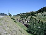
West portals of Bozeman Pass tunnels built by the Northern Pacific Railway. The original 1884 tunnel (abandoned) is on the right, while the newer 1945 tunnel is on the left (now used by Montana Rail Link)
-
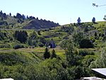
East portal of Montana Rail Link's Bozeman Pass tunnel.


