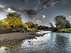
Shields River facts for kids
Quick facts for kids Shields River |
|
|---|---|

Lower Shields River
|
|
| Country | Park and Meagher County, Montana |
| Physical characteristics | |
| Main source | 46°11′19″N 110°18′40″W / 46.18861°N 110.31111°W |
| River mouth | 4,383 feet (1,336 m) 45°43′25″N 110°27′27″W / 45.72361°N 110.45750°W |
| Length | 65.4 miles (105.3 km) |
| Basin features | |
| River system | Yellowstone River |
The Shields River is a beautiful river located in Montana, United States. It flows for about 65 miles (105 kilometers) through Meagher and Park Counties. This river is an important tributary, meaning it flows into, the larger Yellowstone River.
Contents
Exploring the Shields River
Where Does the Shields River Flow?
The Shields River begins high up in the Crazy Mountains, which are part of the Gallatin National Forest. It starts in the northern part of Park County.
From there, the river first flows west, then turns south. It travels between two mountain ranges: the Bridger Range to its west and the Crazy Mountains to its east.
As it flows, the river passes by small towns like Wilsall and Clyde Park. Finally, it joins the Yellowstone River about 10 miles (16 kilometers) northeast of Livingston.
How Did the Shields River Get Its Name?
The Shields River was named after a person named John Shields (explorer). He was an important member of the famous Lewis and Clark Expedition. This expedition explored the western parts of the United States in the early 1800s.
What Fish Live in the Shields River?
The Shields River is home to several types of fish. You can find native fish like the Yellowstone cutthroat trout and Mountain whitefish.
There are also fish that were introduced to the river, such as brown and rainbow trout. These fish make the Shields River a great place for fishing!
 | Jackie Robinson |
 | Jack Johnson |
 | Althea Gibson |
 | Arthur Ashe |
 | Muhammad Ali |

