Stanford, Montana facts for kids
Quick facts for kids
Stanford, Montana
|
|
|---|---|

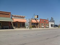
Central Avenue Stanford
|
|

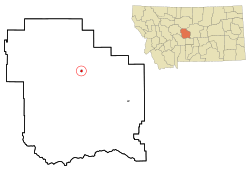
Location of Stanford, Montana
|
|
| Country | United States |
| State | Montana |
| County | Judith Basin |
| Area | |
| • Total | 0.43 sq mi (1.11 km2) |
| • Land | 0.43 sq mi (1.11 km2) |
| • Water | 0.00 sq mi (0.00 km2) |
| Elevation | 4,285 ft (1,306 m) |
| Population
(2020)
|
|
| • Total | 403 |
| • Density | 939.39/sq mi (362.56/km2) |
| Time zone | UTC-7 (Mountain (MST)) |
| • Summer (DST) | UTC-6 (MDT) |
| ZIP code |
59479
|
| Area code(s) | 406 |
| FIPS code | 30-70675 |
| GNIS feature ID | 2413327 |
Stanford is a small town in Montana, United States. It is the main town, or county seat, of Judith Basin County. In 2020, about 403 people lived here.
Stanford started as a trading post in 1875. It was set up by Thomas C. Power. Later, in 1908, the town moved about 3 miles. This was so it could be closer to the new railroad.
The town's main business is farming. In 2023, a company called Redwood Group decided to open a facility here. They will process and store grains used for high-quality pet food.
The famous artist C.M. Russell often visited Stanford. You can even see the town in some of his landscape paintings.
Contents
Exploring Stanford's Location and Weather
Stanford covers a small area of land. It is about 0.44 square miles (1.11 square kilometers) in size. The town is located in a basin. This basin is surrounded by the Highwood, Big Snowy, and Little Belt mountains.
The area around Stanford is mostly farmland. Farmers here raise livestock and grow small grains. U.S. Route 87 passes right through the town.
Nearby, you can find Ackley Lake State Park. This is one of the few public lakes in Central Montana. It's a great place for fun outdoor activities. You can go fishing for different types of trout and kokanee salmon.
Understanding Stanford's Climate
Stanford has a climate with warm summers and cold winters. The weather can change a lot throughout the year.
| Climate data for Stanford, Montana, 1991–2020 normals, extremes 1927–present | |||||||||||||
|---|---|---|---|---|---|---|---|---|---|---|---|---|---|
| Month | Jan | Feb | Mar | Apr | May | Jun | Jul | Aug | Sep | Oct | Nov | Dec | Year |
| Record high °F (°C) | 71 (22) |
73 (23) |
78 (26) |
87 (31) |
92 (33) |
102 (39) |
102 (39) |
104 (40) |
99 (37) |
90 (32) |
78 (26) |
70 (21) |
104 (40) |
| Mean maximum °F (°C) | 60.6 (15.9) |
58.6 (14.8) |
65.9 (18.8) |
74.4 (23.6) |
79.9 (26.6) |
87.2 (30.7) |
93.5 (34.2) |
93.3 (34.1) |
88.9 (31.6) |
79.3 (26.3) |
67.6 (19.8) |
57.9 (14.4) |
95.4 (35.2) |
| Mean daily maximum °F (°C) | 38.0 (3.3) |
38.1 (3.4) |
46.0 (7.8) |
54.1 (12.3) |
63.0 (17.2) |
71.1 (21.7) |
81.6 (27.6) |
81.1 (27.3) |
71.0 (21.7) |
57.3 (14.1) |
45.1 (7.3) |
37.5 (3.1) |
57.0 (13.9) |
| Daily mean °F (°C) | 26.8 (−2.9) |
27.0 (−2.8) |
34.4 (1.3) |
42.0 (5.6) |
50.6 (10.3) |
58.5 (14.7) |
66.9 (19.4) |
66.3 (19.1) |
57.3 (14.1) |
45.0 (7.2) |
34.1 (1.2) |
26.7 (−2.9) |
44.6 (7.0) |
| Mean daily minimum °F (°C) | 15.5 (−9.2) |
16.0 (−8.9) |
22.7 (−5.2) |
29.9 (−1.2) |
38.2 (3.4) |
46.0 (7.8) |
52.3 (11.3) |
51.5 (10.8) |
43.5 (6.4) |
32.8 (0.4) |
23.0 (−5.0) |
16.0 (−8.9) |
32.3 (0.1) |
| Mean minimum °F (°C) | −14.2 (−25.7) |
−9.9 (−23.3) |
−1.6 (−18.7) |
12.4 (−10.9) |
24.0 (−4.4) |
34.1 (1.2) |
40.5 (4.7) |
38.9 (3.8) |
27.9 (−2.3) |
10.9 (−11.7) |
−2.4 (−19.1) |
−11.6 (−24.2) |
−22.9 (−30.5) |
| Record low °F (°C) | −42 (−41) |
−44 (−42) |
−29 (−34) |
−19 (−28) |
2 (−17) |
23 (−5) |
29 (−2) |
29 (−2) |
15 (−9) |
−11 (−24) |
−35 (−37) |
−40 (−40) |
−44 (−42) |
| Average precipitation inches (mm) | 0.57 (14) |
0.48 (12) |
0.86 (22) |
1.90 (48) |
3.10 (79) |
3.00 (76) |
1.70 (43) |
1.61 (41) |
1.50 (38) |
1.31 (33) |
0.69 (18) |
0.60 (15) |
17.32 (439) |
| Average precipitation days (≥ 0.01 in) | 6.2 | 7.1 | 7.9 | 10.5 | 12.6 | 13.1 | 9.7 | 8.6 | 7.3 | 7.6 | 5.9 | 6.4 | 102.9 |
| Source 1: NOAA | |||||||||||||
| Source 2: National Weather Service | |||||||||||||
Who Lives in Stanford?
| Historical population | |||
|---|---|---|---|
| Census | Pop. | %± | |
| 1920 | 300 | — | |
| 1930 | 509 | 69.7% | |
| 1940 | 529 | 3.9% | |
| 1950 | 542 | 2.5% | |
| 1960 | 615 | 13.5% | |
| 1970 | 505 | −17.9% | |
| 1980 | 595 | 17.8% | |
| 1990 | 529 | −11.1% | |
| 2000 | 454 | −14.2% | |
| 2010 | 401 | −11.7% | |
| 2020 | 403 | 0.5% | |
| U.S. Decennial Census | |||
In 2010, there were 401 people living in Stanford. These people lived in 198 households. About 110 of these were families. The town had 247 housing units in total.
Most people in Stanford are White (97.3%). A small number are Native American (2.0%). Even fewer are African American (0.2%) or from other backgrounds. About 1.5% of the population was Hispanic or Latino.
About 22.2% of households had children under 18 living there. Many households (47.0%) were married couples. About 40.4% of all households were individuals living alone. About 17.7% of these were people aged 65 or older.
The average age in Stanford was 49.4 years. About 19.5% of residents were under 18. About 21.4% were 65 or older. The town had slightly more males (51.4%) than females (48.6%).
Fun Things to Do and See
The Judith Basin County Museum is located in Stanford. It's a local history museum. You can see many old items and displays there.
The CMR Stampede is a big annual event in Stanford. It's a PRCA rodeo. This community event includes a street dance, a pancake breakfast, and a barbecue dinner. There are also running and bike races, and a quickdraw art contest.
The Judith Basin County Free Library serves the town. It's a great place to find books and learn new things.
Learning in Stanford
Stanford Public Schools teach students from kindergarten through 12th grade. Stanford High School is a Class C school. This means it has less than 108 students. This class size helps decide how athletic competitions are set up. The school's sports teams are known as the Wolves.
Local News and Radio
The Judith Basin Press is the local newspaper. It is published every week.
The radio station KYPF is also in Stanford. It is a translator station for Yellowstone Public Radio.
Getting Around Stanford
U.S. Highway 87 passes by the southwest side of Stanford. Montana Highway 80 starts in Stanford. It connects with US 87, MT 3, and MT 200 in town.
Stanford Airport is also known as Biggerstaff Field. It is owned by the county and open to the public. The airport is located one mile (2 km) south of town.
Famous People from Stanford
- Albert Henry Ottenweller, a Roman Catholic bishop
See also
 In Spanish: Stanford (Montana) para niños
 | Frances Mary Albrier |
 | Whitney Young |
 | Muhammad Ali |

