
Highwood Mountains facts for kids
The Highwood Mountains are a special kind of mountain range in north central Montana, U.S.. They are called an "island range" because they are a part of the larger Rocky Mountains but are completely surrounded by flat prairie land. Imagine an island of mountains in a sea of grass!
These mountains cover a large area, about 4,659 square kilometers (1,799 square miles). They are found across three different counties: Chouteau, Judith Basin, and Cascade. You can find them east of the city of Great Falls and the Benton Lake National Wildlife Refuge. They are also at the northern edge of the Lewis and Clark National Forest.
Contents
Exploring the Highwood Mountains
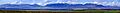
The Highwood Mountains are a fascinating place to explore. They offer beautiful views and unique natural features.
Where Are the Highwood Mountains?
Besides being near Great Falls, these mountains are close to the town of Highwood, Montana. The famous Missouri River also flows nearby, just above where the Marias River joins it. This area is known for its wide-open spaces and stunning natural beauty.
What is the Highest Point?
The tallest peak in the Highwood Mountains is called Highwood Baldy. It stands very high at 2,338 meters (7,670 feet). That's like stacking over 1,000 average-sized cars on top of each other!
How Were the Mountains Formed?
The Highwood Mountains have a fiery past! They were formed by volcanoes long ago. This means they have a lot of igneous rocks, which are rocks formed when hot, melted rock (magma or lava) cools down.
The area is also rich in a mineral called potash. Many of the rocks that came out of the volcanoes (called extrusive rocks) have special, clear crystals inside them. These crystals are called analcime. Another interesting mineral found here is pseudoleucite.
To the north of the Highwood Mountains, you can find a cool landform called the Shonkin Sag. This is a channel that was carved out by melting ice from a glacier long ago. It shows how powerful ancient ice could be!
History of the Highwood Mountains
The Highwood Mountains have been part of important protected areas.
National Forest History
For a while, the Highwood Mountains were part of their own special forest area called the Highwood Mountains National Forest. This lasted until 1908. After that, this area became part of the larger Lewis and Clark National Forest. This change helped protect the mountains and their natural environment for future generations.
Images for kids
-
Southern face of Highwood Mountains
