Wardner, Idaho facts for kids
Quick facts for kids
Wardner, Idaho
|
|
|---|---|

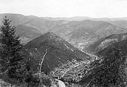
Wardner in 1904 (foreground), separated from Kellogg (middle ground), by the conical hill called Haystack Peak
|
|

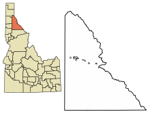
Location of Wardner in Shoshone County, Idaho.
|
|
| Country | United States |
| State | Idaho |
| County | Shoshone |
| Area | |
| • Total | 0.87 sq mi (2.26 km2) |
| • Land | 0.87 sq mi (2.26 km2) |
| • Water | 0.00 sq mi (0.00 km2) |
| Elevation | 3,196 ft (974 m) |
| Population
(2010)
|
|
| • Total | 188 |
| • Density | 201.83/sq mi (77.95/km2) |
| Time zone | UTC-8 (Pacific (PST)) |
| • Summer (DST) | UTC-7 (PDT) |
| ZIP code |
83837
|
| Area code(s) | 208, 986 |
| FIPS code | 16-85240 |
| GNIS feature ID | 2412180 |
Wardner is a small city in Shoshone County, Idaho, in the United States. It is located in the Silver Valley, an area known for mining. In 2010, about 188 people lived there.
| Top - 0-9 A B C D E F G H I J K L M N O P Q R S T U V W X Y Z |
Geography of Wardner
Wardner covers a small area of land. It is about 0.87 square miles (2.26 square kilometers) in size. All of this area is land, with no water.
History of Wardner
How Wardner Got Its Name
The city of Wardner is named after Joe Wardner. He was an important person in the early days of the Bunker Hill and Sullivan mine in the 1880s. He also helped sell land lots in the new city.
Joe Wardner was born in Wisconsin in 1846. He worked in many different jobs and places, like Arizona, California, and South Dakota. After his time in Idaho's Silver Valley, he followed mining opportunities to places like South Africa and the Klondike. He wrote a book about his life in 1900 and passed away in 1905.
Mining History and Challenges
The Silver Valley region, where Wardner is located, has a long history of mining. In the late 1800s, there were some big disagreements between mine workers and mine owners.
In 1892, miners in Shoshone County went on strike. They were protesting against lower wages. During this time, there were some serious conflicts, and the U.S. army had to step in to help end the strike.
More problems happened in 1899. The mining company fired some workers for joining a union. In response, the miners caused damage to the Bunker Hill & Sullivan mill. Again, the army came to help calm things down.
Wardner Today
Today, a special cable car system, called a gondola, passes over Wardner. This gondola is part of the Silver Mountain ski resort, which is a popular place for winter sports.
Population of Wardner
Wardner's Population Over Time
The number of people living in Wardner has changed over many years. Here is a look at how the population has grown and shrunk:
| Historical population | |||
|---|---|---|---|
| Census | Pop. | %± | |
| 1910 | 1,369 | — | |
| 1920 | 704 | −48.6% | |
| 1930 | 903 | 28.3% | |
| 1940 | 861 | −4.7% | |
| 1950 | 772 | −10.3% | |
| 1960 | 577 | −25.3% | |
| 1970 | 492 | −14.7% | |
| 1980 | 423 | −14.0% | |
| 1990 | 246 | −41.8% | |
| 2000 | 215 | −12.6% | |
| 2010 | 188 | −12.6% | |
| 2019 (est.) | 176 | −6.4% | |
| U.S. Decennial Census | |||
Wardner in 2010
According to the 2010 census, there were 188 people living in Wardner. These people lived in 75 different homes, and 60 of those were families.
Most of the people living in Wardner in 2010 were White (95.2%). A small number were Native American (1.1%), Asian (1.6%), or from other backgrounds. About 2.7% of the people were Hispanic or Latino.
The average age of people in Wardner was 46 years old. About 20.2% of the residents were under 18 years old. About 51.6% of the population was male, and 48.4% was female.
Images for kids
See also
 In Spanish: Wardner (Idaho) para niños
 | William Lucy |
 | Charles Hayes |
 | Cleveland Robinson |


