
National Register of Historic Places listings in Shoshone County, Idaho facts for kids

Have you ever wondered about the old buildings and special places in your community? Many of these places are important parts of history. In Shoshone County, Idaho, there are many such spots that are officially recognized for their historical value. They are listed on something called the National Register of Historic Places.
The National Register of Historic Places is like a special list kept by the United States government. It helps protect places that are important to American history, architecture, archaeology, engineering, or culture. When a place is on this list, it means it's a treasure that should be preserved for future generations. Shoshone County has 24 amazing places and areas on this list, each with its own unique story!
Contents
Historic Places in Shoshone County
Let's explore some of the cool historic places you can find in Shoshone County. These sites tell us about the past, from early settlements to big events like the 1910 fires.
Avery's Historic Buildings
The town of Avery, Idaho is home to several historic sites, many connected to the area's logging and railroad history.
Avery Depot

The Avery Depot is an old train station located on St. Joe River Road in Avery. It was built in 1910 and was a very busy place when trains were the main way to travel and transport goods. This depot is also part of a group of sites linked to the huge 1910 fires that swept through North Idaho. It reminds us of the challenges people faced back then.
Avery Ranger Station
The Avery Ranger Station is another important site near the St. Joe National Forest. This station was built in 1910 and helped manage the vast forests and protect them from fires. It shows how important forestry and conservation have been in this part of Idaho.
Bullion Tunnel
East of Avery, you can find the Bullion Tunnel. This tunnel is also connected to the 1910 fires. It was likely used as a refuge or part of the efforts to fight the massive wildfires that devastated the region.
Cedar Snags

North of Avery, you'll find the Cedar Snags. These are tall, dead cedar trees that were left standing after the 1910 fires. They serve as a natural memorial to the incredible power of those fires and how they shaped the landscape. They are a stark reminder of the past.
Milwaukee Railroad Historic District
The Chicago, Milwaukee, St. Paul and Pacific Railroad Company Historic District is a very long historic area that even stretches into Montana! This district includes parts of the old Milwaukee Road railway line. This railway was a huge engineering feat, bringing trains through tough mountain terrain. Today, parts of it are used as the "Trail of the Hiawatha," a popular biking trail.
Murray's Mining History
The town of Murray, Idaho, once a bustling mining town, has a few historic buildings that tell its story.
John C. Feehan House
The John C. Feehan House on Main Street in Murray is a historic home. It belonged to John C. Feehan, an important person in the town's early days. Homes like this give us a peek into how people lived in the past.
Murray Courthouse

The Murray Courthouse on Main Street is a significant building. It was originally built in 1884. Sadly, it collapsed in 1997 due to heavy snow. But don't worry, it was rebuilt to look just like the original! This shows how much the community valued its history.
Murray Masonic Hall
The Murray Masonic Hall is another historic building on Main Street in Murray. Masonic halls were often important community centers where people gathered for meetings and events.
Wallace: The Silver City
Wallace, Idaho is known as the "Silver City" because of its rich mining history. Many of its buildings are on the National Register.
Northern Pacific Railway Depot

The Northern Pacific Railway Depot at 219 6th Street in Wallace was once a busy train station. Like the Avery Depot, it played a big role in connecting Wallace to the rest of the country, especially for transporting silver and other mined materials.
Edward Pulaski Tunnel and Placer Creek Escape Route

Southwest of Wallace, you'll find the Edward Pulaski Tunnel and Placer Creek Escape Route. This site is named after Edward Pulaski, a brave forest ranger who saved many lives during the devastating 1910 fires. He led his crew into a mining tunnel to escape the flames. This site is a powerful reminder of the courage shown during that terrible event.
U.S. Post Office – Wallace Main

The U.S. Post Office – Wallace Main on Cedar Street is a historic building that has served the community for many years. Post offices were, and still are, important places for communication and connecting people.
Wallace 1910 Fire Memorial

North of Wallace, the Wallace 1910 Fire Memorial stands as a tribute to the victims and heroes of the 1910 fires. These fires were some of the largest and most destructive in U.S. history, and this memorial helps us remember their impact.
Wallace Carnegie Library

The Wallace Carnegie Library on River Street is a beautiful historic building. It was built with money donated by Andrew Carnegie, a famous businessman who funded thousands of libraries across the country. These libraries helped spread knowledge and education.
Wallace Historic District
The Wallace Historic District is a large area in Wallace that includes many historic buildings. It's roughly bounded by streets like Oak, Silver, and Cedar. Walking through this district is like stepping back in time, with many buildings showing the architecture and style of the late 1800s and early 1900s.
Other Notable Sites
Shoshone County has other interesting places on the National Register of Historic Places too!
Pine Creek Baptist Church

The Pine Creek Baptist Church in Pinehurst, Idaho, located at Main and S. 3rd Streets, is a historic church building. Churches often serve as important community gathering places and reflect the history of the people who lived there.
St. Andrew's Episcopal Church

In Mullan, Idaho, you can find St. Andrew's Episcopal Church on Hunter Street. This church is another example of the historic places of worship in the county.
U.S. Post Office – Kellogg Main

The U.S. Post Office – Kellogg Main at 302 S. Division Street in Kellogg, Idaho, is also on the National Register. Like the Wallace post office, it's a key part of the town's history and services.
These historic places in Shoshone County are more than just old buildings; they are windows into the past, helping us understand the stories of the people who lived, worked, and built communities in Idaho.
Images for kids
-
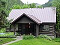
The Avery Work Center, part of the Avery Ranger Station.
-
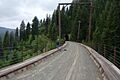
A view of the "Trail of the Hiawatha," which follows part of the historic Milwaukee Road railway.


