
Lapwai, Idaho facts for kids
Quick facts for kids
Lapwai, Idaho
|
|
|---|---|

Downtown Lapwai in early summer
|
|

Location of Lapwai in Nez Perce County, Idaho.
|
|
| Country | United States |
| State | Idaho |
| County | Nez Perce |
| Area | |
| • Total | 0.77 sq mi (1.98 km2) |
| • Land | 0.76 sq mi (1.96 km2) |
| • Water | 0.01 sq mi (0.03 km2) |
| Elevation | 955 ft (291 m) |
| Population
(2010)
|
|
| • Total | 1,137 |
| • Estimate
(2019)
|
1,137 |
| • Density | 1,503.97/sq mi (580.55/km2) |
| Time zone | UTC-8 (Pacific (PST)) |
| • Summer (DST) | UTC-7 (PDT) |
| ZIP code |
83540
|
| Area code(s) | 208, 986 |
| FIPS code | 16-45370 |
| GNIS feature ID | 0396768 |
Lapwai is a city in Nez Perce County, Idaho, United States. In 2010, about 1,137 people lived there. It is the main place of government for the Nez Perce Indian Reservation.
Contents
History of Lapwai
The area where Lapwai is now was once home to a leader named Hin-ma-tute-ke-kaikt, also known as Big Thunder. Later, he was called James. In 1836, a Christian mission was started here for the Nez Perce. This mission was led by Henry Spalding.
A man named Bill Craig also settled in this area. His wife was James' daughter. From 1863 to 1884, a military post called Fort Lapwai operated here. The village of Lapwai officially became a city in 1911. It even had a special rural school.
The name "Lapwai" means "place of the butterflies." This is because many years ago, thousands of butterflies would gather here in early summer. Lapwai is also part of the larger Lewiston, Idaho-Washington area.
Geography of Lapwai
Lapwai is located at 46°24′16″N 116°48′16″W / 46.40444°N 116.80444°W. It sits about 955 feet (291 meters) above sea level.
The city covers about 0.81 square miles (2.1 square kilometers) of land. Only a tiny part, about 0.01 square miles (0.03 square kilometers), is water.
Lapwai is in a valley created by Lapwai Creek. This creek flows into the Clearwater River about 3 miles south of the city. The hills on both sides of Lapwai rise sharply. They go up more than 600 feet in less than a mile. U.S. Route 95, a major highway, goes right through Lapwai.
Transportation in Lapwai
Highways
 - US 95 connects Lapwai to Lewiston (north and west) and Grangeville (southeast).
Railroads
The city has a freight train service called the BG&CM Railroad. This railroad uses old tracks that were once part of the Camas Prairie Railroad.
Education in Lapwai
Public schools in Lapwai are managed by the Lapwai School District #341. The main school is Lapwai High School.
Population and People
| Historical population | |||
|---|---|---|---|
| Census | Pop. | %± | |
| 1870 | 91 | — | |
| 1880 | 165 | 81.3% | |
| 1920 | 359 | — | |
| 1930 | 416 | 15.9% | |
| 1940 | 426 | 2.4% | |
| 1950 | 480 | 12.7% | |
| 1960 | 500 | 4.2% | |
| 1970 | 400 | −20.0% | |
| 1980 | 1,043 | 160.8% | |
| 1990 | 932 | −10.6% | |
| 2000 | 1,134 | 21.7% | |
| 2010 | 1,137 | 0.3% | |
| 2019 (est.) | 1,137 | 0.0% | |
| U.S. Decennial Census | |||
2010 Census Information
In 2010, there were 1,137 people living in Lapwai. There were 369 households and 272 families. The city had about 1,421 people per square mile.
Most people in Lapwai were Native American (78.1%). Other groups included White (16.6%), African American (0.4%), and Asian (0.1%). About 4.1% of people were from two or more races. Also, 4.0% of the population was Hispanic or Latino.
Many households (46.9%) had children under 18 living with them. About 35.2% were married couples. Other households included single parents or people living alone. The average household had about 3 people. The average family had about 3.5 people.
The average age of people in Lapwai was 30.8 years old. About 31.4% of residents were under 18. And 9.3% were 65 or older. The population was almost evenly split between males (48.7%) and females (51.3%).
Famous People from Lapwai
- Lillian Disney, who was the wife of Walt Disney.
- Chaske Spencer, an actor who played Sam Uley in the Twilight movies.
Images for kids
-
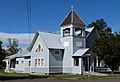
Historic First Presbyterian Church
-
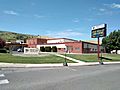
Nimiipuu Health Center


See also
 In Spanish: Lapwai para niños
