
Grays Peak facts for kids
Quick facts for kids Grays Peak |
|
|---|---|

Grays Peak on left, Torreys Peak on right
|
|
| Highest point | |
| Elevation | 14,278 ft (4352 m) NAVD88 |
| Prominence | 2770 ft (844 m) |
| Isolation | 25.0 mi (40.2 km) |
| Listing |
|
| Naming | |
| Etymology | Asa Gray |
| Geography | |

Grays Peak
Location in Colorado
|
|
| Location | High point of the Continental Divide in North America and the high point of both Clear Creek and Summit counties, Colorado, U.S. |
| Parent range | Highest summit of the Front Range |
| Topo map | USGS 7.5' topographic map Grays Peak, Colorado |
| Climbing | |
| First ascent | 1861 by Charles C. Parry |
| Easiest route | 3.5 mile (5.6 km) hike on Grays Peak Trail |
Grays Peak is a very tall mountain in Colorado, U.S.. It stands at 14,278 ft (4,352 m) high. This makes it the tenth-highest mountain in the Rocky Mountains of North America. It is also the highest point in the Front Range mountain group.
Grays Peak is special because it sits right on the Continental Divide of the Americas. This means that water falling on one side flows to the Atlantic Ocean, and water on the other side flows to the Pacific Ocean. The mountain is located between Clear Creek and Summit counties. It is the highest point in both of these counties.
Grays Peak is one of Colorado's 53 "fourteeners." A fourteener is a mountain that is over 14,000 feet (4,300 m) tall. The first person to officially climb Grays Peak was a botanist named Charles C. Parry in 1861. He named the mountain after his friend, also a botanist, Asa Gray. Gray himself didn't climb the peak until 1872. Grays Peak is often talked about with its neighbor, Torreys Peak, which is very close by.
Contents
Climbing Grays Peak

Grays Peak is a popular mountain for hikers. It is considered an easier climb compared to some other fourteeners. Many people like to hike Grays Peak and then continue to Torreys Peak, which is less than a mile away.
Getting to the Trailhead
The main path to the top is called the Grays Peak Trail. To start your hike, you need to get to the Stevens Gulch Trailhead. You can reach it by taking I-70 west from Denver for about 50 miles (80 km). Take exit 221 for Bakerville Road. From there, drive south on Stevens Gulch Road for about 2.5 miles (4.0 km) until you reach the trailhead.
The road to the trailhead can be rough. It's best to use a vehicle with high clearance, like a four-wheel-drive car or an all-terrain vehicle. This helps with the deep cuts and large rocks on the road.
Hiking the Trail
From the trailhead, the hike is about 3.5 miles (5.6 km) long. You will climb about 3,040 feet (930 m) in elevation. The trail is easy to follow and well-used. It starts with a gentle slope along the gulch. Then, it gets steeper as you get closer to the top.
At the very top of Grays Peak, there's a small rock shelter shaped like a "U." You might find a log book there where climbers can write their names. From the summit, you can see amazing views. You can look south towards Pikes Peak, east to the Great Plains, west to Silverthorne, and north to Longs Peak and Rocky Mountain National Park.
If you want to keep going, the trail continues from Grays Peak's summit north to Torreys Peak. The path goes down to a saddle at 13,707 ft (4,178 m) before climbing back up to the top of Torreys Peak at 14,274 ft (4,351 m).
Wildlife and Plants
The area around Grays Peak is home to many different animals and plants.
Animals
You might see animals like mountain goats, pikas, cougars (also called mountain lions), mule deer, elk, marmots, coyotes, ptarmigans, American red squirrels, and Canada jays.
Plants
In the tundra areas along the Continental Divide of the Americas, you can find beautiful wildflowers. These include moss campion (Silene acaulis), alpine forget-me-not (Myosotis alpestris), sky pilot (Polemonium viscosum), sea pink, old-man-of-the-mountain (Rydbergia grandiflora), and mountain gentian (Gentiana).
Below the tree-line, you can find other colorful blooms. These include monkshood (or wolfsbane), blue columbine, fireweed, and paintbrush (Castilleja).
Images for kids
-
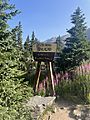
Grays Peak trailhead
-
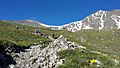
Cairn along trail
-
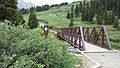
Footbridge at the beginning of the trail


See also
 In Spanish: Pico Grays para niños
