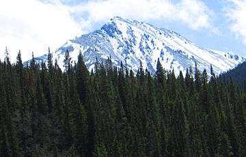
Torreys Peak facts for kids
Torreys Peak is a tall mountain in the Rocky Mountains of Colorado. It is part of the Front Range. This mountain is one of Colorado's 53 "fourteeners." A fourteener is a mountain that is over 14,000 feet (about 4,267 meters) high. Torreys Peak is near the city of Denver. It sits right on the Continental Divide, which separates rivers flowing to the Atlantic from those flowing to the Pacific. The mountain also marks the border between Clear Creek County and Summit County.
Quick facts for kids Torreys Peak |
|
|---|---|

Torreys Peak seen from I-70
|
|
| Highest point | |
| Elevation | 14,267 ft (4,349 m) |
| Prominence | 560 ft (171 m) |
| Isolation | 0.65 mi (1.05 km) |
| Listing | Colorado Fourteener 12th |
| Naming | |
| Etymology | John Torrey |
| Geography | |
| Location | Continental Divide between Clear Creek and Summit counties, Colorado, United States |
| Parent range | Front Range |
| Topo map | USGS 7.5' topographic map Grays Peak, Colorado |
| Climbing | |
| First ascent | 1861 by Charles C. Parry |
| Easiest route | 4.5 mi (7.2 km) hike on Grays Peak Trail |
Contents
How Torreys Peak Got Its Name
The first European to climb Torreys Peak was a botanist named Charles C. Parry. He named the mountain after his friend and fellow botanist, John Torrey. Interestingly, John Torrey did not see the peak himself until 1872. This was 11 years after it was named, and just one year before he passed away at age 76. Torreys Peak is often talked about with its close neighbor, Grays Peak.
Hiking to the Top of Torreys Peak
There are three main paths you can take to reach the summit of Torreys Peak. Each path offers a different adventure for hikers.
Starting from Grays Peak Trail
One way to reach Torreys Peak is by continuing from the Grays Peak Trail. This trail begins in a place called Stevens Gulch. You can find more details about how to get to this starting point in the Grays Peak article.
The Challenging Kelso Ridge Route
For experienced hikers, there is a popular and more difficult path called Kelso Ridge. This route splits off from the Grays Peak trail about 2 miles (3.2 km) from the start. It climbs up to a saddle, which is a low point between two peaks. This saddle is between Torreys Peak and Kelso Mountain, at about 12,400 feet (3,780 meters) high. From there, you follow a rugged ridge for about 1 mile (1.6 km) to the summit of Torreys Peak.
The Loveland Pass Trail
A third trail starts at Loveland Pass, which is about 4.5 miles (7.2 km) to the northwest. To get to Loveland Pass, you can drive west from Denver on I-70 for about 55 miles (88.5 km). Then, US Route 6 branches off and heads south. Follow Route 6 for about seven miles until you reach the trailhead at Loveland Pass. The elevation here is 11,990 feet (3,655 meters).
The Steep Start
The trail begins with a steep climb right away. You will go up about 1,000 feet (305 meters) in just half a mile. The path then follows the Continental Divide. It gently takes you down into three saddles and up two more peaks. These peaks include Grizzly Peak at 13,427 feet (4,093 meters) and Mount Sniktau at 13,234 feet (4,034 meters).
The Final Climb
The last saddle on this trail is around 12,600 feet (3,840 meters). From this point, it is a 1-mile (1.6 km) climb of about 1,800 feet (549 meters) to reach the very top of Torreys Peak.
Continuing to Grays Peak
Once you are at the summit of Torreys Peak, many hikers choose to continue their adventure to Grays Peak. It is only about 0.75 miles (1.2 km) away. The trail between Torreys Peak and Grays Peak dips down to a saddle at 13,707 feet (4,178 meters) and then climbs back up to 14,270 feet (4,350 meters).
 | Dorothy Vaughan |
 | Charles Henry Turner |
 | Hildrus Poindexter |
 | Henry Cecil McBay |


