
Bierstadt Lake facts for kids
Quick facts for kids Bierstadt Lake |
||||||
|---|---|---|---|---|---|---|
Clockwise from the top:
|
||||||

Bierstadt Lake
Location in Colorado

Bierstadt Lake
Location in the United States
|
||||||
| Location | Larimer County, Colorado | |||||
| Coordinates | 40°19′37″N 105°37′26″W / 40.327°N 105.624°W | |||||
| Type | Glacial lake | |||||
| Etymology | Albert Bierstadt | |||||
| Part of | Mill Creek Basin | |||||
| Primary inflows | Upper Mill Creek | |||||
| Primary outflows | Mill Creek | |||||
| Managing agency | Rocky Mountain National Park | |||||
| Designation | 1932 | |||||
| Surface elevation | 9,419 ft (2,871 m) | |||||
| Settlements | Estes Park, Colorado | |||||


Bierstadt Lake is a beautiful lake located in Larimer County, Colorado. You can find it inside the famous Rocky Mountain National Park. From the lake, you get amazing views of the Continental Divide. This is a mountain ridge that separates rivers flowing to the Atlantic from those flowing to the Pacific.
The lake is near McHenrys Peak and Longs Peak. The main path to the lake, called the Bierstadt Lake Trailhead, is about 6.5 miles (10.5 km) from the park's entrance on U.S. Route 36. In summer, you can even take a shuttle bus to the trailhead.
Bierstadt Lake sits on top of a large pile of rocks and dirt. This pile was left behind by a melting glacier. The lake's water flows into Mill Creek. The lake is named after Albert Bierstadt, a famous artist. He painted many landscapes in the 1870s, including scenes of Longs Peak and Bierstadt Lake. Some of his paintings are now in the Denver Art Museum.
How the Lake Was Formed
Bierstadt Lake sits on a high, flat area called the Bierstadt Moraine. This huge moraine was created by the Bartholf Glacier. A glacier is like a giant, slow-moving river of ice. As the Bartholf Glacier moved, it picked up lots of rocks and dirt. When the glacier melted, it left all this material behind. This created a natural dam. Water then collected behind this dam, forming Bierstadt Lake.
The lake's water drains into Mill Creek. This creek flows through a flat valley with a pretty meadow. The long ridge where the lake sits is one of the most impressive glacial features in the Rocky Mountain National Park.
History and Naming

Long ago, Native Americans called this place "Hanging Lake." They gave it this name because it seemed to hang high up on the side of the Bartholf Glacier.
The lake officially received the name Bierstadt Lake in 1932. Before that, the name appeared on a map in 1922. Like Mount Bierstadt, the lake was named to honor Albert Bierstadt. He was a landscape artist who visited and painted the Rocky Mountains. He might have been the first European to climb Mount Evans in 1863.
In 1876, a rich man named Windham Wyndham-Quin asked Bierstadt to paint a very large picture. It was to show Longs Peak and Estes Park. Bierstadt traveled around the area with Theodore Whyte, who worked for the rich man. They made sketches and paintings. They also looked for a good spot to build a hotel with a great view of Longs Peak. Bierstadt really liked the lake, and Whyte is said to have named it after the artist. Bierstadt created one of his famous paintings of the West at this lake. An early historian, Harold Marion Dunning, wrote that Bierstadt's favorite spot for sketching was on the shore of the lake that now carries his name.
Bierstadt's painting of the lake is now in the Denver Art Museum. Some people think an 1877 painting by Bierstadt, which has "Whyte's Lake" written on the back, might have been named for Whyte first. It was possibly renamed for Bierstadt later. There's also a story that Whyte's Lake was a lake made by people. It might have been washed away in a flood the year after the painting was made.
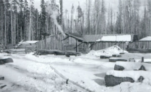
Near the lake, there used to be a sawmill called Griffith Sawmill by 1907. This sawmill provided wood for the farms and ranches being built nearby. Sawmills often worked through the winter. They used sleds to move wood to help settlers build homes and shops. Wood from this sawmill was even used to build The Stanley Hotel. In 1910, the Griffith Sawmill moved to a new location.
Exploring Rocky Mountain National Park

Bierstadt Lake is located off Bear Lake Road, in an area called the "Heart of the Park." This area is known for its amazing views and easy access. Many trails offer wonderful chances to take photos of the scenery, plants, animals, and interesting land features.
Around the lake, you can see aspen and pine trees. A thick pine forest surrounds Bierstadt Lake. The edge of the lake is covered in sedges, which are grass-like plants. This makes the lake look very calm and peaceful. You might also spot waterfowl (birds that live on water), Abert's squirrels, deer, and elk in the area.
There are two main trails to Bierstadt Lake within the park. One trail is an easy, mostly downhill walk of about 1.6 miles (2.6 km). It goes through pine and aspen forests and starts at the Bear Lake Trailhead. Another trail is an uphill climb of 1.4 miles (2.3 km) with switchbacks (zigzag paths). This trail starts at the Bierstadt Lake Trailhead. About 1⁄10 mile (0.2 km) into this trail, you'll find a horse corral.
Near the lake, you can see famous peaks like Longs Peak, Flattop Mountain, Hallett Peak, and Tyndall Glacier. There's also a 0.6-mile (0.97 km) trail that goes all the way around the lake. The eastern part of the lake even has a sandy beach!
Another scenic path, the Hollowell Park trail, leads to the Bierstadt Lake area. It goes through thick sagebrush and meadows. You can also find the Fern Lake and Cub Lake trails nearby. Remember, picnicking and fishing are not allowed at Bierstadt Lake.
