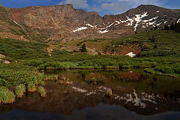
Mount Bierstadt facts for kids
Quick facts for kids Mount Bierstadt |
|
|---|---|

Reflections of Mount Bierstadt (right) and The Sawtooth (left)
|
|
| Highest point | |
| Elevation | 14,065 ft (4,287 m) |
| Prominence | 720 ft (219 m) |
| Isolation | 1.12 mi (1.80 km) |
| Listing | Colorado Fourteener 38th |
| Naming | |
| Etymology | Albert Bierstadt |
| Geography | |
| Location | Clear Creek County, Colorado, United States |
| Parent range | Front Range, Colorado Peaks |
| Topo map | USGS 7.5' topographic map Mount Evans, Colorado |
| Climbing | |
| First ascent | 1863 Albert Bierstadt |
| Easiest route | 7 mile hike |
Mount Bierstadt is a very tall mountain peak in the Rocky Mountains of North America. It is part of the Front Range in Colorado. This mountain is special because it is one of Colorado's "fourteeners." A fourteener is a mountain that is over 14,000 feet (about 4,267 meters) high. Mount Bierstadt stands at 14,065 feet (4,287 meters).
The mountain is located in the Mount Evans Wilderness area. This wilderness is part of the Pike National Forest in Clear Creek County, Colorado, United States. It was named after Albert Bierstadt, a famous American landscape painter. He was the first person to record climbing to the top of the mountain in 1863.
Contents
Exploring Mount Bierstadt
Mount Bierstadt is about 1.4 miles (2.2 kilometers) west of Mount Evans. It is also about 43.8 miles (70.5 kilometers) west of downtown Denver.
Many people enjoy climbing Mount Bierstadt. It is considered one of the easier fourteeners to climb. Its location close to Denver also makes it very popular. The best time to climb Mount Bierstadt is usually in July and August. During these months, the weather is often good for hiking.
Climbing the Mountain
Most climbers start their journey from Guanella Pass. This pass is located to the west of the mountain. From Guanella Pass, the hike is about 7 miles (11 kilometers) long. You will climb about 2,391 feet (729 meters) in elevation.
The trail first goes down slightly into a flat, wet area. This area is near Scott Gomer Creek. After that, the trail starts to climb the western slopes of Mount Bierstadt. As you get higher, the mountain becomes rocky. The path is marked by piles of stones called cairns. These cairns help hikers stay on the right track. The trail becomes flatter about 200 feet (61 meters) below the very top. This flat part is called a saddle point. From there, it's a final climb to the summit. There are also other trails on the eastern side of the mountain for longer hikes.
Beyond the Summit: The Sawtooth
Once you reach the top of Mount Bierstadt, some hikers choose to continue their adventure. A popular option is to hike along a ridge called The Sawtooth to nearby Mount Evans. This part of the hike is more challenging. It is considered an intermediate-level hike.
Sometimes, hikers on The Sawtooth will take a detour. They might go down to Abyss Lake. This lake is at an elevation of 12,650 feet (3,856 meters). It sits at the bottom of the valley between Mount Bierstadt and Mount Evans.
Albert Bierstadt's Legacy
Albert Bierstadt was a well-known American landscape painter. He visited the area around Mount Bierstadt in 1863. He made many sketches during his trip. One of his famous paintings is A Storm in the Rocky Mountains, Mt. Rosalie. This painting was inspired by the sketches he made there.
The painting shows either Mount Spalding or Mount Evans. It is not clear which mountain it is. Bierstadt and his guide, William Byers, climbed to the top of either Evans or Spalding during their visit.
 | Shirley Ann Jackson |
 | Garett Morgan |
 | J. Ernest Wilkins Jr. |
 | Elijah McCoy |


