The Sawtooth facts for kids
Quick facts for kids The Sawtooth |
|
|---|---|

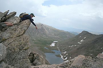
A climber leaning on an overhang that's part of the sawtooth. Behind him, to the left, is Mount Evans, and Mount Bierstadt is to the right, off screen. Abyss Lake can be seen below.
|
|
| Highest point | |
| Elevation | 13,786 ft (4,202 m) |
| Prominence | 120 ft (37 m) |
| Isolation | 0.62 mi (1.00 km) |
| Geography | |
| Location | Clear Creek County, Colorado, United States |
| Parent range | Front Range, Chicago Peaks |
| Topo map | USGS 7.5' topographic map Mount Evans, Colorado |
| Climbing | |
| Easiest route | Class 3 from Guanella Pass, 6.75 mile round trip |
The Sawtooth is a cool, jagged mountain ridge in central Colorado. It connects Mount Bierstadt to Mount Evans. This ridge looks like the teeth of a saw, which is how it got its name!
Contents
What is The Sawtooth?
The Sawtooth is a type of landform called an arête. An arête is a narrow, sharp ridge of rock. It is often formed when two glaciers carve away rock on either side.
The Sawtooth has three main points that stick up like saw teeth. It's a famous spot for hikers and climbers.
Where is The Sawtooth Located?
This amazing ridge is part of the Front Range mountains in Colorado. It's found in Clear Creek County.
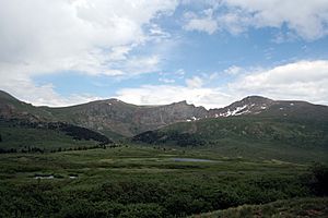
One side of The Sawtooth faces southeast. This side forms the top edge of a bowl-shaped valley called a cirque. This cirque sits above a lake called Abyss Lake. The other side, facing northwest, forms another cirque above Guanella Pass.
The northeast end of The Sawtooth connects to the shoulder of Mount Spalding. From there, another ridge leads towards Mount Evans. This second ridge separates the glacial valley of Abyss Lake from Summit Lake.
How Was The Sawtooth Formed?
The unique shape of The Sawtooth was created by glaciers. Thousands of years ago, huge sheets of ice moved through these mountains. As glaciers moved, they carved out valleys and cirques.
When two glaciers moved on opposite sides of a mountain, they slowly wore away the rock. This process left behind a sharp, narrow ridge like The Sawtooth. The jagged points are what's left of the rock that resisted the ice.
Climbing The Sawtooth
Many people enjoy hiking and climbing in the area around The Sawtooth. One popular way to reach it is from Guanella Pass. This route is about 6.75 miles long, round trip.
The easiest way to climb The Sawtooth is considered a "Class 3" route. This means you'll need to use your hands for balance and climbing in some spots. It's more than just walking, but it's not quite rock climbing that needs ropes. It's a fun challenge for experienced hikers!

 | Bessie Coleman |
 | Spann Watson |
 | Jill E. Brown |
 | Sherman W. White |


