
Mount Blue Sky facts for kids
Quick facts for kids Mount Blue Sky |
|
|---|---|

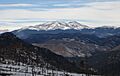
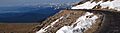
Mount Blue Sky seen from the south.
|
|
| Highest point | |
| Elevation | 14,271 feet (4,350 m) NAVD88 |
| Prominence | 2,770 feet (844 m) |
| Isolation | 9.79 miles (15.76 km) |
| Listing |
|
| Geography | |

Mount Blue Sky
Location in Colorado
|
|
| Location | Clear Creek County, Colorado, U.S. |
| Parent range | Front Range |
| Topo map | USGS 7.5' topographic map Mount Blue Sky, Colorado |
| Climbing | |
| First ascent | disputed: 1863 by Albert Bierstadt 1872 by Judge Lunt |
| Easiest route | West Ridge from Summit Lake: Hike, class 2 |
Mount Blue Sky (formerly Mount Evans) is a very tall mountain in the Rocky Mountains of North America. It is the highest point in the Mount Evans Wilderness area. This impressive mountain is 14,271-foot (4,350 m) high. Mountains over 14,000 feet are often called "fourteeners."
Mount Blue Sky is located in Clear Creek County, Colorado, United States. It is about 13.4 miles (21.6 km) southwest of Idaho Springs. The mountain is part of the Front Range, a section of the Rocky Mountains.
You can see Mount Blue Sky from far away, even over 100 miles (160 km) to the east. It stands out in the skyline of the Denver metropolitan area, rising over 9,000 feet (2,700 m) above the city. People in Denver can easily spot this huge peak.
The mountain was once named after John Evans, an early governor of Colorado. However, his actions during the Sand Creek Massacre in 1864 led to many discussions about changing the name. On September 15, 2023, the mountain was officially renamed Mount Blue Sky. This new name honors the Cheyenne and Arapaho Native American tribes.
Contents
Exploring Mount Blue Sky's Location
Mount Blue Sky is the highest point in a group of mountains called a massif. It is about 35 miles (56 km) west of Denver in a straight line. By road, it is about 51 miles (82 km) away, usually reached through Idaho Springs.
Nearby Peaks and Lakes
Other tall peaks are part of the same mountain group:
- Mount Spalding (13,842 ft or 4,219 m), about 1.1 mi (1.8 km) northwest
- Gray Wolf Mountain (13,602 ft or 4,146 m), about 2.2 mi (3.5 km) north-northwest
- The Sawtooth (13,780 ft or 4,200 m), about 1.2 mi (1.9 km) west
- Mount Bierstadt (14,060 ft or 4,290 m), about 1.5 mi (2.4 km) west-southwest
Deep, bowl-shaped valleys called cirques cut into the mountain group. Many of these cirques hold small lakes called tarns. Some important tarns include:
- Summit Lake, about 0.5 miles (0.80 km; 800 m) north
- The Chicago Lakes, about 2 miles (3.2 km; 3,200 m) north
- Abyss Lake, about 1 mile (1.6 km; 1,600 m) west-southwest
Roads and Trails for Adventure
The Mount Blue Sky Scenic Byway is a famous road that leads close to the summit. It includes Highway 103 from Idaho Springs, Colorado to Echo Lake. Then, Colorado 5 continues for 15 miles (24 km) to a parking area near the top. This part of the road is the highest paved road in North America and is only open in the summer.
Another scenic road, the Guanella Pass Scenic Byway, passes about 4 miles (6.4 km) west of Mount Blue Sky. It connects Georgetown with Grant.
There are also hiking trails for those who want to explore on foot. One trail follows the highway from Echo Lake to the summit. Another trail links Guanella Pass to Mount Bierstadt.
Most of the Mount Blue Sky area is part of the Mount Evans Wilderness. This means it is protected land in the Arapaho National Forest and Pike National Forest. Summit Lake Park and Echo Lake Park are also protected as part of Denver's historic mountain parks.
A Look Back at Mount Blue Sky's Past

Many different Native American tribes have historical connections to the land around Mount Blue Sky. At least 48 tribes consider this area part of their ancestral lands.
Early Explorers and Artists
In 1863, the painter Albert Bierstadt and his guide, William Newton Byers, explored the mountain. Bierstadt first called it Mount Rosalie, after his future wife. He painted many sketches of the mountain from the Chicago Lakes. His famous painting, A Storm in the Rocky Mountains, Mt. Rosalie, was inspired by these sketches.
Later, in 1873, William Henry Jackson visited the Chicago Lakes. He took many photographs as part of the Hayden Survey. This survey measured Mount Rosalie's height as 14,330 feet (4,370 m) using a method called triangulation.


Building the Highest Road
The story of the Mount Blue Sky Scenic Byway is linked to the Denver Mountain Parks system. Denver wanted to build scenic roads for people to enjoy the mountains. One plan was to build a road up Mount Blue Sky.
Building this road was a huge challenge. It involved the City of Denver, the U.S. Congress, the State Highway System, and the U.S. Forest Service. The road from Echo Lake to the peak was first surveyed in 1923. Workers faced many difficulties, like a flu outbreak and strong winds. High-altitude construction was also tough, as machines worked less effectively. The last 600 feet of the road were built by hand. The entire road was finally finished in 1930.
Crest House and Scientific Discoveries
Near the summit are the ruins of the Crest House. This building, built in 1941–1942, once had a restaurant and gift shop. It burned down in 1979 and was not rebuilt. Today, its stone walls offer shelter and a great viewing spot for visitors.
In 2017, Mount Blue Sky and Echo Lake were named historic sites. This was to remember the many cosmic-ray physics experiments done on the mountain between 1935 and 1960.
Mount Blue Sky also hosts the yearly Mt. Evans Hill Climb. This is a 27.4 miles (44.1 km) bicycle race with a total climb of 6,915 feet (2,108 m).

The Environment of Mount Blue Sky

Understanding the Climate
The air pressure on the summit is much lower than at sea level. This means there is less oxygen, and many people can get altitude sickness.
The weather on Mount Blue Sky's summit is very harsh. The average yearly temperature is 18 °F (−8 °C). Temperatures often drop below 0 °F (−18 °C), and can even reach −40 °F (−40 °C). Even in summer, temperatures can fall below freezing. Winds are also very strong, often blowing from 25 to 30 knots (29 to 35 mph; 46 to 56 km/h).
| Climate data for Mount Blue Sky 39.5835 N, 105.6454 W, Elevation: 13,665 ft (4,165 m) (1991–2020 normals) | |||||||||||||
|---|---|---|---|---|---|---|---|---|---|---|---|---|---|
| Month | Jan | Feb | Mar | Apr | May | Jun | Jul | Aug | Sep | Oct | Nov | Dec | Year |
| Mean daily maximum °F (°C) | 19.9 (−6.7) |
19.1 (−7.2) |
24.9 (−3.9) |
31.3 (−0.4) |
39.7 (4.3) |
50.4 (10.2) |
56.1 (13.4) |
53.4 (11.9) |
47.5 (8.6) |
36.9 (2.7) |
26.6 (−3.0) |
20.2 (−6.6) |
35.5 (1.9) |
| Daily mean °F (°C) | 8.9 (−12.8) |
7.9 (−13.4) |
13.1 (−10.5) |
18.6 (−7.4) |
27.3 (−2.6) |
37.4 (3.0) |
43.4 (6.3) |
41.5 (5.3) |
35.4 (1.9) |
25.3 (−3.7) |
16.1 (−8.8) |
9.5 (−12.5) |
23.7 (−4.6) |
| Mean daily minimum °F (°C) | −2.0 (−18.9) |
−3.2 (−19.6) |
1.2 (−17.1) |
5.9 (−14.5) |
14.9 (−9.5) |
24.4 (−4.2) |
30.7 (−0.7) |
29.5 (−1.4) |
23.2 (−4.9) |
13.7 (−10.2) |
5.5 (−14.7) |
−1.2 (−18.4) |
11.9 (−11.2) |
| Average precipitation inches (mm) | 3.58 (91) |
3.22 (82) |
3.43 (87) |
4.69 (119) |
3.31 (84) |
2.15 (55) |
3.55 (90) |
3.08 (78) |
2.11 (54) |
2.15 (55) |
2.80 (71) |
2.93 (74) |
37 (940) |
| Source: PRISM Climate Group | |||||||||||||
Rare Tornado Event
On July 28, 2012, a small tornado briefly touched down northeast of the summit. It was at an elevation of about 11,900 feet (3,600 m). This was the second highest tornado ever recorded in the United States. Luckily, it caused no damage because it was above the tree line.
Plants and Trees (Flora)

Mount Blue Sky has different plant zones. Below Echo Lake, you'll find forests of lodgepole pine and blue spruce. Higher up, in the subalpine forest, there are Engelmann spruce and bristlecone pine.
At the tree line, trees become small and twisted. This is called krummholz. The bristlecone pine trees on Mount Goliath are very old. Some started growing in the year 403 AD! These ancient trees are protected in the Mount Goliath Natural Area.
Above the tree line, the land is mostly alpine tundra. Here, you'll see small plants like dwarf willow and colorful flowers. Near the summit, plants grow in tiny, compact cushions between rocks.
The tundra around Summit Lake is special. It's often called the southernmost arctic tundra in the world. This is because the ground is wet and has permafrost (permanently frozen soil) underneath.
Animals (Fauna)

Many animals live on Mount Blue Sky. Mountain lions and black bears are top predators. They hunt animals like bighorn sheep and mountain goats. You can also find many yellow-bellied marmots.
Above the tree line, small animals like pikas are common. Below the tree line, you might see elk and mule deer.
Birds like the white-tailed ptarmigan live on the mountain. They are so well camouflaged that they are hard to spot! Other birds include Brown-capped rosy finches and rock wrens.
How Mount Blue Sky Was Formed (Geology)
Mount Blue Sky was shaped from a large body of rock called the Mount Evans Batholith. This rock formed about 1.4 billion years ago when hot, melted rock (magma) pushed into the Earth's crust. Most of the rock is granodiorite, which is similar to granite.
Over time, glaciers carved deep glacial cirques and canyons into this rock. The lakes around Mount Blue Sky, like Summit Lake and the Chicago Lakes, are tarns. They are located in these cirques or glacial canyons. Echo Lake was formed by a natural dam created by a glacier.
Science and Research on the Mountain

Because the Mount Blue Sky Highway makes the summit easy to reach, it has become a popular place for scientists to do research.
Cosmic Ray Studies
In 1931, Arthur H. Compton did important research on cosmic rays here. The University of Denver even built special buildings on the summit for cosmic-ray scientists. By the 1950s, Mount Blue Sky was one of the best places in the world for high-altitude physics experiments.
In 1939, Bruno Rossi made the first accurate measurement of the muon particle's lifetime. He used sites at Mount Blue Sky, Echo Lake, Denver, and Chicago. This experiment helped prove time dilation, a key idea in Einstein's theory of relativity.
Many universities, including MIT and Chicago, conducted experiments on the mountain in 1948. Later, in the 1960s, the Midwestern Universities Research Association used cosmic rays to study high-energy physics.
Observatories and Life Science
The University of Denver built a telescope on the summit in 1972. This telescope was used to observe comets. In 1996, the university built the Meyer–Womble Observatory near the summit. From 1972 to 1999, this was the world's highest optical observatory.
Mount Blue Sky has also been important for life sciences research. In 1940, a major study on how the human body reacts to high altitude was done here. In 1966, pioneering studies on how altitude training affects track athletes were also conducted on the mountain.
The Mount Evans Road is also used by car companies. They test new vehicles at high altitudes here.
Why the Name Changed
Mount Evans was named after John Evans, who was the second governor of the Colorado Territory. However, investigations by universities found that Governor Evans was connected to the Sand Creek Massacre of 1864. This event led to the deaths of many Cheyenne and Arapaho people, including women and children.
Because of this history, there were many efforts to change the mountain's name. In 2020, Colorado Governor Jared Polis created a board to look at renaming places. Mount Evans was on their list.
The new name, Mount Blue Sky, was suggested by the Southern Cheyenne and Arapaho Tribes. They explained that the name "signifies the Arapaho as they were known as the Blue Sky People and the Cheyenne who have an annual ceremony of renewal of life called Blue Sky."
In March 2022, Clear Creek County approved the name change. On November 17, 2022, the Colorado Geographic Naming Advisory Board also agreed. Finally, on September 15, 2023, the United States Board on Geographic Names officially changed the mountain's name to Mount Blue Sky.
Even though the mountain's name changed, the Mount Evans Wilderness Area still needs approval from Congress to change its name to Mount Blue Sky Wilderness. A bill has been introduced in Congress to make this change.
Images for kids
-
Mount Blue Sky seen from the south.
-
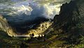
A Storm in the Rocky Mountains, Mt. Rosalie, a painting by Albert Bierstadt (1866).
-
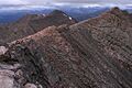
Looking west along ridge from summit.
-
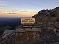
The United States Forest Service sign at the summit of Mount Blue Sky.
-
Mount Blue Sky Scenic Byway above Summit Lake, the highest paved road in North America.
-

Summer crowds on Mount Blue Sky summit, July 3, 2011.
-
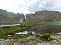
Summit Lake Park on Mount Blue Sky.
-
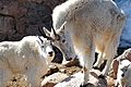
Mountain goats on Mt Blue Sky.
-
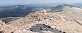
View from the summit of Mount Blue Sky of the end of the Mount Blue Sky Scenic Byway, Crest House and the Meyer–Womble Observatory, 2010.
See also
 In Spanish: Monte Evans para niños
