
Denver Mountain Parks facts for kids
The Denver Mountain Parks system is a huge area of parklands in the mountains and foothills of Colorado. It covers more than 14,000 acres! These parks are located west and south of Denver in Jefferson, Clear Creek, Douglas, and Grand counties.

The City and County of Denver owns and takes care of these parks. The system started in 1910. To buy land outside the city, Denver needed special permission from the U.S. Congress in 1914. The main goal was to keep the beautiful Rocky Mountain scenery safe forever. It also aimed to protect native forests and create a fun mountain playground for everyone. This way, visitors to Denver could easily enjoy the mountains.
Today, the Denver Mountain Parks system has 22 developed parks. It also includes many undeveloped areas. These areas are important for open space, amazing views, and homes for wildlife. The parks range from 5,800 to 13,000 feet above sea level. Many parks have picnic spots, and some have hiking trails. J.J.B. Benedict designed many of the park buildings. He used local stone and wood to make them blend into the natural surroundings. This style is called "mountain architecture." Some shelters in Genesee Park and Dedisse Park were built in the late 1930s by the Civilian Conservation Corps, a group that helped people find jobs during the Great Depression.
The Denver Mountain Parks have many different types of natural areas. These include grassy prairies, mountain meadows, forests along rivers, and different kinds of pine and spruce forests. There are even high-altitude areas called alpine tundra. Bison herds were brought to Genesee Park in 1914 and later to Daniels Park. This was part of a plan to bring bison back to Colorado, as they had disappeared from the state.
Contents
History of the Mountain Parks
How the Parks Began
Around 1909-1910, people started talking about creating a mountain park near Denver. John Brisben Walker and Denver's Mayor Robert W. Speer were big supporters of this idea. Walker talked to different groups in Denver, like the Real Estate Exchange and the Chamber of Commerce. These groups formed a "Joint Committee" to explore the idea. In May 1912, Denver voters approved a special tax to help pay for the project.
Planning and Growth
In 1912, a famous landscape architect named Frederick Law Olmsted, Jr. was hired. He planned the park system. Olmsted suggested that Denver buy over 41,000 acres of land. This land would be for parks, mountain roads, and to protect scenic views. The first park, Genesee Park, was started in 1912. It is still the largest at 2,413 acres. The last new parks were Red Rocks Park, bought in 1927-1928, and O'Fallon Park and Newton Park, which were given as gifts in 1939. Winter Park was also bought in 1939, and Daniels Park was made bigger around that time.
Special Recognition and Future Plans
Many of the main parks in the system were added to the National Register of Historic Places in 1990 and 1995. This means they are recognized as important historical sites. Two roads built by Denver in 1912-1914, the Bear Creek Canyon Scenic Mountain Drive and the Lariat Trail Scenic Mountain Drive, were also included. These roads are now part of the Lariat Loop Scenic & Historic Byway. You can find a list of these parks at National Register of Historic Places listings in Jefferson County, Colorado.
In 1955, the special funding for the parks stopped. They became part of the Denver Parks and Recreation Department. For a while, the parks were not well cared for. Because of this, the Denver Mountain Parks Foundation was started in 2004. This group works to support the parks. In 2008, the Foundation and the Parks Department created a new plan for the system. This plan looks at how valuable the parks are to Denver residents. It also suggests ways to fund, promote, and protect the parks for the future. A new logo was created for the park system to help give it a clear identity.
In 2013, the Denver Mountain Parks Foundation and the City of Denver celebrated 100 years of the park system. They released a book called Denver Mountain Parks: 100 Years of the Magnificent Dream. It shares the park's history, old photos, and a guide to the parks.
List of Mountain Parks
The Denver Mountain Parks include many different types of properties. Some parks, like Red Rocks Park and Echo Lake, are very well known and visited often. Others are more remote or smaller and are not used as much, like Pence Park. Most parks have picnic areas and restrooms. Some are considered "developed" just because they are easy to get to. A few park names are the same as parks in Jefferson County Open Space.
| Traditional Developed Parks | Conservation/wilderness Areas | |||
|---|---|---|---|---|
These developed parklands are key to the system. They offer mountain recreation for city residents. People from Denver and visitors have used these parks since the 1910s.
|
A large part of the Denver Mountain Parks is made up of areas that were meant to stay undeveloped. Some of these (marked with asterisks) are next to Jefferson County Open Space parks. They might have trails because of shared efforts. Many are surrounded by private land and cannot be accessed by the public. These conservation areas include:
|
Images for kids
-
Denver Mountain Parks logo
-
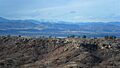
Daniels Park in Douglas County
