

- This page was last modified on 17 October 2025, at 11:18. Suggest an edit.
Lariat Loop Scenic & Historic Byway facts for kids
|
[[File:|x70px|alt= marker]] |
|
|---|---|
| Lua error in Module:Infobox_road/map at line 15: attempt to index field 'wikibase' (a nil value). | |
| Highway system | |
| Colorado State Highways |
The Lariat Loop Scenic & Historic Byway is a special road trip route in the beautiful foothills of Colorado. It's about 40 miles (64 km) long and connects the towns of Golden, Morrison, and Evergreen. This scenic drive is located about 20 miles (32 km) west of Denver, Colorado, offering amazing views and a peek into history.
Contents
Exploring the Lariat Loop Byway
This amazing byway includes parts of several important roads. You'll drive on State Highway 93 between Golden and Morrison. Then, it follows State Highway 74 from Morrison all the way to Evergreen through the scenic Bear Creek Canyon. This same road then goes north to Interstate 70, which cuts through the loop.
The Historic Lariat Trail
A key part of the loop is the Lariat Trail. This trail connects Golden with the very top of Lookout Mountain. The Lookout Mountain Road then finishes the loop back to Interstate 70. This whole route helped the surrounding 150 square miles (388 km²) area become a Colorado Heritage Area in 2000. The Lariat Loop itself was officially named a Byway in April 2002. You can also connect to the Mount Evans Scenic Byway from here using Squaw Pass Road.
A Journey Through Nature and History
The Lariat Loop Byway mixes together natural beauty, interesting culture, and important history. People have been promoting this route as a fun place to visit since 1914! You can enjoy the drive in about half a day from Denver. Along the way, you'll find many historic places, beautiful parks, and other cool attractions. Many of these spots are even listed on the National Register of Historic Places.
The Lariat Loop is also part of Denver’s original "circle drives." These drives were created in 1914 as part of the unique Denver Mountain Parks system. The area has diverse geography, meaning it has many different kinds of landscapes. You'll see thick forests, amazing mountain views, winding roads, rocky cliffs, and historic "beauty spots." Many of these beautiful areas are now county or city parks, so everyone can visit them.
All the roads along the Lariat Loop Byway are easy to drive in a regular car. Services like gas stations and restaurants are available all year round. Remember, the Open Space and Mountain Parks are protected areas. This means all the wildlife and plants there are safe and should not be disturbed.
Fun Places to Visit on the Lariat Loop
There are so many exciting places to stop and explore along the Lariat Loop! Here are some of the popular attractions you might want to check out:
- Jefferson County Open Space Parks
- Denver Mountain Parks
- Buffalo Bill Museum & Grave
- Lookout Mountain Nature Center & Preserve
- Boettcher Mansion
- Chief Hosa Lodge
- Humphrey Memorial Park & Museum
- Evergreen Lake
- Hiwan Homestead Museum
- Morrison Natural History Museum
- Morrison Historical District
- Dinosaur Ridge
- Red Rocks Park and Red Rocks Amphitheatre
- Mother Cabrini Shrine
- National Renewable Energy Laboratory (NREL)
- Mines Museum of Earth Science
- Foothills Art Center
- Rocky Mountain Quilt Museum
- Golden Visitors Center
- Golden Pioneer Museum
- Astor House Museum
- Clear Creek History Park
- Colorado Railroad Museum
Images for kids
-
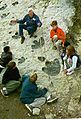
Dinosaur footprints along the Lariat Loop Scenic and Historic Byway