Mount Evans Scenic Byway facts for kids
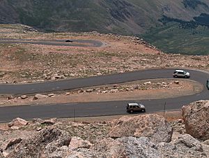
The Mount Evans Scenic Byway is an amazing road in Colorado, USA. It's known as the highest paved road in all of North America! This special road is about 28 miles (45 km) long. As you drive, it climbs over 7,000 feet (2,134 m) in elevation. The byway ends near the top of Mount Evans, reaching a super high point of 14,130 feet (4,307 m) above sea level. It's a fantastic way to see incredible mountain views!
Quick facts for kids
[[File:|x70px|alt= marker]] |
|
|---|---|
| Lua error in Module:Infobox_road/map at line 15: attempt to index field 'wikibase' (a nil value). | |
| Route information | |
| Length | 28 mi (45 km) |
| Highway system | |
| Colorado State Highways | |
Contents
Exploring the Mount Evans Byway
The Mount Evans Scenic Byway starts near the town of Idaho Springs. You can find it by taking Exit 241 off I-70. It's a good idea to stop at the Idaho Springs Visitor Center first. There, you can get maps and information about your trip.
From the visitor center, you'll follow Miner Street to 13th Avenue. This road becomes State Highway 103 and then State Highway 5. The byway winds its way through a beautiful area called the Mount Evans Wilderness. This wilderness is a protected natural space.
Planning Your Trip: Fees and Access
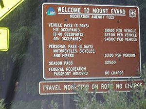
If you plan to use the parking lots and facilities along the upper parts of the byway, there is a park fee. This fee helps maintain the road and the areas around it.
The Mount Evans Scenic Byway is usually only open for a short time each year. It typically opens around Memorial Day weekend in late May and closes after Labor Day in early September. However, the exact opening and closing dates can change. It all depends on the weather and how much snow is on the road. Sometimes, heavy snow can keep parts of the road closed longer.
Driving Safely on the Byway
The upper part of the byway can be quite narrow. There are also some places with sudden drop-offs and no guardrails. It's important to drive carefully and pay attention to the road. Always follow the speed limits and watch out for wildlife.
History of the Mount Evans Road
The idea for this amazing road began a long time ago. The Denver Mountain Parks system first planned it. They wanted to connect parks like Summit Lake Park and Echo Lake Park to other parks at lower elevations.
The original plan was for the road to go from Bergen Park (near Evergreen) to Echo Lake, and then all the way to the summit of Mount Evans. Even from the very beginning, the people planning the road wanted to make sure it offered incredible views. The route was chosen by a famous landscape architect named Frederick Law Olmsted, Jr..
A National Park Idea
For a few years, between 1915 and 1920, there was a plan to create a National Park in this area. The Mount Evans Scenic Byway was going to be the main road to access this new park. The proposed park would have included much of what is now the Mount Evans Wilderness Area.
Special Designations
The Mount Evans Scenic Byway has received special recognition for its beauty and importance.
- On July 1, 1993, the US Forest Service named it a National Forest Scenic Byway. This means it's one of the most beautiful roads in the national forests.
- The Colorado Department of Transportation has also called it a Colorado Scenic Byway. This highlights its importance as a scenic and historic route within Colorado.
 | Jackie Robinson |
 | Jack Johnson |
 | Althea Gibson |
 | Arthur Ashe |
 | Muhammad Ali |


