Fraser, Colorado facts for kids
Quick facts for kids
Fraser, Colorado
|
||
|---|---|---|
| Town of Fraser | ||

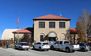
Cozens Ranch Museum (1874)
|
||
|
||

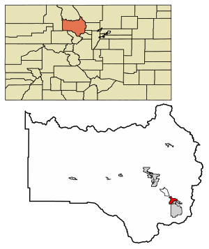
Location of the Town of Fraser in Grand County, Colorado.
|
||
| Country | ||
| State | ||
| County | Grand County | |
| Established | 1871 | |
| Incorporated (town) | June 15, 1953 | |
| Government | ||
| • Type | Statutory Town | |
| Area | ||
| • Total | 3.462 sq mi (8.966 km2) | |
| • Land | 3.457 sq mi (8.953 km2) | |
| • Water | 0.005 sq mi (0.013 km2) | |
| Elevation | 8,813 ft (2,686 m) | |
| Population
(2020)
|
||
| • Total | 1,400 | |
| • Density | 404/sq mi (156/km2) | |
| • Grand County | 15,717 | |
| Time zone | UTC−07:00 (MST) | |
| • Summer (DST) | UTC−06:00 (MDT) | |
| ZIP code |
80442
|
|
| Area code(s) | 970 | |
| FIPS code | 08-28305 | |
| GNIS feature ID | 2412655 | |
The Town of Fraser is a small town in Grand County, Colorado, United States. It's known as a "Statutory Town," which means it follows certain rules set by the state. In 2020, about 1,400 people lived there. This was a good increase from 2010.
Fraser is located in a valley called Middle Park, right by the Fraser River. It's also along U.S. Highway 40. The town is close to Winter Park, which has a very popular ski resort. Because of this, Fraser has grown a lot recently, with new homes and buildings being built.
Contents
Fraser's Story: A Look at Its Past
Fraser became an official town in 1953. Before that, it had a post office that opened in 1876. The town got its name from an early settler named Reuben Frazer.
Where is Fraser? Its Geography
Fraser is in the southeastern part of Grand County. To its south is the town of Winter Park. To the north, you'll find Tabernash, which is not an official town.
U.S. Route 40 is a main road that goes through Fraser. If you drive southeast on this road, you'll reach Denver in about 71 miles. If you go northwest, you'll get to Granby, the biggest town in Grand County, in about 15 miles.
In 2020, Fraser covered about 8.966 square kilometers of land. A tiny part, about 0.013 square kilometers, is water. The Fraser River flows through the eastern side of the town. It then heads north towards the Colorado River.
Fraser's Weather: The "Icebox of the Nation"
Fraser is one of the coldest towns in the lower 48 states of the U.S. The average temperature is around 38 degrees Fahrenheit (3.3 degrees Celsius). It can even get frost any time of the year! This means it has about 287 nights below freezing (32 degrees Fahrenheit or 0 degrees Celsius). Only places in northern Alaska and Bodie, California are similar.
Fraser also has many nights where the temperature drops below 0 degrees Fahrenheit (-18 degrees Celsius). It has about 63 such nights each year. The town also experiences about 60 days where the temperature never gets above freezing.
Fraser and International Falls, Minnesota have both claimed the nickname "Icebox of the Nation." This has led to some friendly competition between the two towns over the years.
Fraser has a subarctic climate. This means it has long, cold winters and short, cool summers. The hottest temperature ever recorded in Fraser was 93 degrees Fahrenheit (34 degrees Celsius) on August 1, 1969. The coldest was -43 degrees Fahrenheit (-42 degrees Celsius) on January 10, 1962.
It snows a lot in Fraser, with an average of about 143.2 inches (3.6 meters) of snow each year. The most snow in one month was 82.4 inches (2.1 meters) in February 1936.
A unique fact about Fraser is that a freeze has been recorded on every single day of the year. This is very rare for any place in the United States.
| Climate data for Fraser, Colorado, 1991–2020 normals, extremes 1989–present | |||||||||||||
|---|---|---|---|---|---|---|---|---|---|---|---|---|---|
| Month | Jan | Feb | Mar | Apr | May | Jun | Jul | Aug | Sep | Oct | Nov | Dec | Year |
| Record high °F (°C) | 50 (10) |
53 (12) |
65 (18) |
74 (23) |
81 (27) |
87 (31) |
93 (34) |
84 (29) |
82 (28) |
75 (24) |
65 (18) |
53 (12) |
93 (34) |
| Mean maximum °F (°C) | 42.0 (5.6) |
46.1 (7.8) |
54.8 (12.7) |
64.7 (18.2) |
74.1 (23.4) |
81.0 (27.2) |
83.3 (28.5) |
81.2 (27.3) |
76.7 (24.8) |
69.1 (20.6) |
55.3 (12.9) |
44.1 (6.7) |
83.7 (28.7) |
| Mean daily maximum °F (°C) | 30.8 (−0.7) |
34.4 (1.3) |
42.7 (5.9) |
51.1 (10.6) |
62.1 (16.7) |
72.4 (22.4) |
76.8 (24.9) |
74.5 (23.6) |
68.0 (20.0) |
55.7 (13.2) |
41.1 (5.1) |
30.7 (−0.7) |
53.4 (11.9) |
| Daily mean °F (°C) | 14.9 (−9.5) |
18.2 (−7.7) |
26.7 (−2.9) |
35.4 (1.9) |
44.5 (6.9) |
52.5 (11.4) |
57.4 (14.1) |
55.6 (13.1) |
48.6 (9.2) |
38.3 (3.5) |
25.3 (−3.7) |
15.0 (−9.4) |
36.0 (2.2) |
| Mean daily minimum °F (°C) | −0.9 (−18.3) |
2.0 (−16.7) |
10.7 (−11.8) |
19.8 (−6.8) |
26.9 (−2.8) |
32.6 (0.3) |
38.0 (3.3) |
36.8 (2.7) |
29.1 (−1.6) |
20.9 (−6.2) |
9.5 (−12.5) |
−0.8 (−18.2) |
18.7 (−7.4) |
| Mean minimum °F (°C) | −25.9 (−32.2) |
−23.5 (−30.8) |
−15.0 (−26.1) |
1.1 (−17.2) |
16.0 (−8.9) |
23.8 (−4.6) |
29.6 (−1.3) |
28.4 (−2.0) |
17.5 (−8.1) |
3.2 (−16.0) |
−15.0 (−26.1) |
−24.3 (−31.3) |
−30.9 (−34.9) |
| Record low °F (°C) | −34 (−37) |
−43 (−42) |
−31 (−35) |
−19 (−28) |
3 (−16) |
20 (−7) |
23 (−5) |
24 (−4) |
7 (−14) |
−19 (−28) |
−30 (−34) |
−41 (−41) |
−43 (−42) |
| Average precipitation inches (mm) | 1.94 (49) |
1.43 (36) |
1.79 (45) |
2.04 (52) |
1.27 (32) |
1.18 (30) |
1.90 (48) |
1.73 (44) |
1.63 (41) |
1.62 (41) |
1.37 (35) |
1.68 (43) |
19.58 (496) |
| Average snowfall inches (cm) | 24.7 (63) |
24.7 (63) |
19.4 (49) |
18.6 (47) |
3.0 (7.6) |
0.4 (1.0) |
0.0 (0.0) |
0.0 (0.0) |
1.2 (3.0) |
9.5 (24) |
16.2 (41) |
25.5 (65) |
143.2 (363.6) |
| Average precipitation days (≥ 0.01 in) | 10.7 | 10.8 | 8.3 | 8.8 | 7.4 | 5.8 | 8.9 | 11.1 | 7.9 | 6.9 | 7.9 | 10.4 | 104.9 |
| Average snowy days (≥ 0.1 in) | 10.6 | 10.8 | 7.4 | 6.0 | 0.8 | 0.1 | 0.0 | 0.0 | 0.5 | 3.3 | 7.4 | 10.5 | 57.4 |
| Source 1: NOAA | |||||||||||||
| Source 2: National Weather Service | |||||||||||||
The "Icebox of the Nation" Debate
Fraser, Colorado, has had a friendly disagreement with International Falls, Minnesota, since 1956. Both towns wanted to use the nickname "Icebox of the Nation." After some legal discussions, the U.S. Patent and Trademark Office officially gave the slogan to International Falls on January 29, 2008.
Who Lives in Fraser? Population Facts
| Historical population | |||
|---|---|---|---|
| Census | Pop. | %± | |
| 1960 | 253 | — | |
| 1970 | 221 | −12.6% | |
| 1980 | 470 | 112.7% | |
| 1990 | 575 | 22.3% | |
| 2000 | 910 | 58.3% | |
| 2010 | 1,224 | 34.5% | |
| 2020 | 1,400 | 14.4% | |
| U.S. Decennial Census | |||
In 2000, there were 910 people living in Fraser. They lived in 410 homes. About 25% of these homes had children under 18. The average home had about 2.21 people.
The population was quite young. About 17.9% were under 18, and a large group (46.2%) were between 25 and 44 years old. The average age was 31 years. For every 100 females, there were about 130 males.
Getting Around: Transportation in Fraser
Travel Options
Amtrak offers train service to Fraser and nearby Winter Park (station code: WIP). The California Zephyr train runs daily in both directions. It travels between Chicago, Illinois, and Emeryville, California, near the San Francisco Bay Area.
In 2015, Amtrak also brought back a special train for skiers called the Winter Park Express. This train goes to the Winter Park Resort. In 2025, a stop was added in Fraser. This ski train service had been popular for almost 70 years, first run by the Denver and Rio Grande Western Railroad.
Other ways to get around include the Bustang, which replaced the Greyhound bus. There's also Home James Transportation, which has offered shared rides and private cars since 1982.
Famous People from Fraser
- Susan Anderson, a doctor known as "Doc Susie"
- Carlota D. EspinoZa
More to Explore
- Byers Peak
- Arapaho National Forest
- Saint Louis Creek
See also
 In Spanish: Fraser (Colorado) para niños
 | Dorothy Vaughan |
 | Charles Henry Turner |
 | Hildrus Poindexter |
 | Henry Cecil McBay |


