
Oswego, Illinois facts for kids
Quick facts for kids
Oswego, Illinois
|
|||
|---|---|---|---|

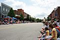
Downtown Oswego
|
|||
|
|||

Location of Oswego in Kendall and Will Counties, Illinois
|
|||

Oswego, Illinois
Location in Chicago metropolitan area

Oswego, Illinois
Location in Illinois

Oswego, Illinois
Location in the United States
|
|||
| Country | United States | ||
| State | Illinois | ||
| Counties | Kendall, Will | ||
| Townships | Oswego, Bristol, Wheatland | ||
| Settled | 1833 | ||
| Incorporated | 1852 | ||
| Area | |||
| • Total | 15.03 sq mi (38.93 km2) | ||
| • Land | 14.89 sq mi (38.56 km2) | ||
| • Water | 0.14 sq mi (0.38 km2) | ||
| Elevation | 659 ft (201 m) | ||
| Population
(2020)
|
|||
| • Total | 34,585 | ||
| • Density | 2,323.01/sq mi (896.93/km2) | ||
| Time zone | UTC−6 (CST) | ||
| • Summer (DST) | UTC−5 (CDT) | ||
| ZIP code |
60543
|
||
| Area codes | 630/331 | ||
| FIPS code | 17-56887 | ||
| GNIS feature ID | 2399593 | ||

Oswego (/ɒsˈwiːɡoʊ/) is a village located in Kendall and Will counties, Illinois, United States. In 2020, about 34,485 people lived there. Oswego is the biggest town in Kendall County. It's part of the larger Chicago metropolitan area, meaning it's a town outside of Chicago where many people live.
Contents
History of Oswego

Early Settlement and Naming
In 1833, William Smith Wilson, his wife Rebecca, and Daniel Pearce moved to the area we now call Oswego. At first, the land belonged to the Potawatomi, Ottawa, and Chippewa Native American tribes. However, the United States government later moved these tribes from their land. This happened as the government began to survey the land along the Fox River in Kendall County. By 1842, the government started selling this land for $1.25 an acre.
After the land was sold, two men from New York, Lewis Brinsmaid Judson and Levi F. Arnold, planned out the village. They first named it "Hudson." But when a post office was set up, its location was called "Lodi." To clear up the confusion, the citizens voted in January 1837. They chose "Oswego" as the village's permanent name by just one vote! The name "Oswego" comes from an Iroquois word meaning "mouth of the stream." It was named after Oswego, New York.
Growth and Development
Oswego grew because of a special spot where people could cross the Fox River. This helped the town's economy. In 1852, Oswego officially became a village. Its first boundaries were Harrison Street, Jefferson Street, Monroe Street, and Benton Street. When cars became popular, Oswego kept growing. It became a central point for three state highways: Illinois Route 25, Illinois Route 71, and Illinois Route 31.
Big changes came in the mid-1950s when large companies like Caterpillar Inc. and Western Electric built factories nearby. This led to the growth of towns like Boulder Hill. Then, in the mid-1980s, many new homes were built in the suburbs. This caused Oswego to expand rapidly, reaching its current size.
Oswego is also known for its old dragstrip on State Route 34. This track was open from 1955 to 1979. People raced powerful "muscle cars" there from all over the Midwest. Even though the track closed decades ago, the town still celebrates its drag racing history. You can still see parts of the old track, but the area is not open to the public.
Geography
Location of Oswego
Oswego is located in the northeastern part of Kendall County. A small part of the village is also in Will County. The Fox River runs through Oswego. To the north, Oswego borders Boulder Hill and Montgomery. To the east, it's next to Aurora, and to the west, it borders Yorkville, which is the main town of Kendall County.
In 2010, Oswego covered about 15.63 square miles (40.5 km2) (40.48 km²) of land. Most of this area, about 15.53 square miles (40.2 km2) (40.22 km²), is land, and a small part, about 0.11 square miles (0.28 km2) (0.28 km²), is water.
Downtown Oswego
Downtown Oswego has many historic buildings and homes. You can also find shops and restaurants there. The Village of Oswego has worked to make the downtown area even better. They added brick walkways, new sidewalks, plants, and decorative streetlights and benches.
Hudson Crossing Park opened in October 2004 along the Fox River. Many children and families enjoy spending time there. The Waubonsee Creek Promenade connects Main Street to this new park. In 2008, the village celebrated its 175th birthday!
Parks and Recreation
The Oswego area has over 1,100 acres (450 ha) (4.5 km²) of open land, trails, and parks. The Oswegoland Park District takes care of these areas. This group was started in 1950 to help create a healthy community. They manage 63 parks, 16 miles (26 km) (26 km) of walking trails, two water parks, and the Little White School Museum. The park district offers many activities for the community and visitors.
Oswego also hosts several races for people who like to stay fit. The park district helps organize different festivals, like the yearly PrairieFest.
Population Facts
| Historical population | |||
|---|---|---|---|
| Census | Pop. | %± | |
| 1880 | 663 | — | |
| 1890 | 641 | −3.3% | |
| 1900 | 618 | −3.6% | |
| 1910 | 600 | −2.9% | |
| 1920 | 676 | 12.7% | |
| 1930 | 932 | 37.9% | |
| 1940 | 978 | 4.9% | |
| 1950 | 1,220 | 24.7% | |
| 1960 | 1,510 | 23.8% | |
| 1970 | 1,862 | 23.3% | |
| 1980 | 3,021 | 62.2% | |
| 1990 | 3,876 | 28.3% | |
| 2000 | 13,326 | 243.8% | |
| 2010 | 30,355 | 127.8% | |
| 2020 | 34,585 | 13.9% | |
| U.S. Decennial Census 2010 2020 |
|||
According to the 2020 census, Oswego had a population of 34,585 people. The village has grown a lot over the years. In 2019, the average household income in Oswego was about $117,624.
Transportation
Major roads that go through Oswego include:
 US 30
US 30 US 34 (Walter Payton Memorial Highway)
 IL 25 (Madison Street)
 IL 31
IL 31 IL 71
IL 71 IL 126
 CR 20 (Orchard Road)
Education
The Oswego Community Unit School District 308 serves students in Oswego and nearby towns like Boulder Hill, Montgomery, Plainfield, Aurora, Yorkville, and Joliet. This school district has 22 schools. These include an early learning center, 14 elementary schools (for grades K-5), 5 junior high schools (for grades 6–8), and 2 high schools. There is also an "opportunity school" for special programs. Some parts of Oswego are also served by Yorkville Community Unit School District 115, which includes Yorkville High School.
Notable people
Many interesting people have connections to Oswego, including:
- Rob Baxley, a former professional football player.
- Arthur M. Beaupre, a diplomat who was born in Oswego.
- Tom Cross, a former member of the Illinois House of Representatives.
- Slade Cutter, a former naval officer and a member of the College Football Hall of Fame.
- Rita B. Garman, a former Chief Justice of the Supreme Court of Illinois.
- Joey Goodspeed, a former professional football player for teams like the Minnesota Vikings.
- AJ Johnson, a professional bowler.
- Alex Magee, a former professional football player.
- Robert Mitchler, an Illinois state senator.
- Robinson B. Murphy, a Civil War Army musician and Medal of Honor recipient.
- Maud N. Peffers, an Illinois state representative.
- Tom Sharpe, a drummer for famous music groups.
- Julianne Sitch, a former professional soccer player and the first woman to win an NCAA championship as a men's team coach.
- Keith R. Wheeler, a member of the Illinois General Assembly.
Awards and recognition
In 2011, CNN/Money Magazine ranked Oswego as #58 on its list of the "Top 100 Best Towns to Live." They chose towns based on things like job opportunities, schools, safety, and economic strength. Kendall County, where Oswego is located, has often been recognized as one of the fastest-growing counties with many new jobs.
Gallery
-
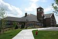
Village hall
-
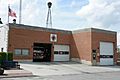
Old fire department
-
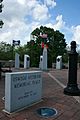
Veteran's Memorial Plaza
-
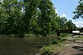
Hudson Crossing Park
-
Downtown during PrairieFest parade


See also
 In Spanish: Oswego (Illinois) para niños
