Western Springs, Illinois facts for kids
Quick facts for kids
Western Springs, Illinois
|
||
|---|---|---|
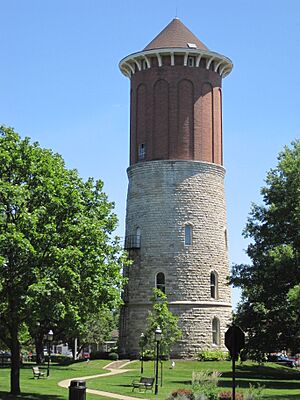
Western Springs Water Tower
|
||
|
||
| Motto(s):
A Village of Towering Character
|
||
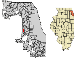
Location of Western Springs in Cook County, Illinois
|
||
| Country | United States | |
| State | Illinois | |
| County | Cook | |
| Township | Lyons Township | |
| Founded | 1886 | |
| Area | ||
| • Total | 2.79 sq mi (7.21 km2) | |
| • Land | 2.79 sq mi (7.21 km2) | |
| • Water | 0.00 sq mi (0.00 km2) | |
| Population
(2020)
|
||
| • Total | 13,629 | |
| • Density | 4,893.72/sq mi (1,889.81/km2) | |
| Time zone | UTC-6 (CST) | |
| • Summer (DST) | UTC-5 (CDT) | |
| ZIP Code(s) |
60558
|
|
| Area code(s) | 708 | |
| FIPS code | 17-80242 | |
| Wikimedia Commons | Western Springs, Illinois | |
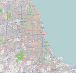
Western Springs is a village in Cook County, Illinois, United States. It is a suburb located near Chicago. In 2020, about 13,629 people lived there.
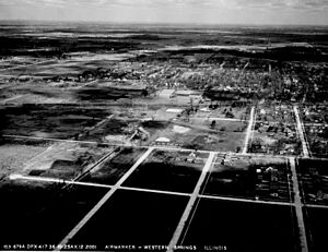
The village got its name from natural mineral springs found on its southwest side. Western Springs was originally flat prairie land with a swamp on its western edge. It is located along the BNSF Railway, which connects Chicago and Aurora. The village is generally found between Willow Springs Road, Ogden Avenue, Interstate 294, and West Plainfield Road.
Contents
History of Western Springs
Early Settlers and Native Americans
Long ago, around the 1700s, Potawatomi Native American tribes lived in the Western Springs area. They might not have built a permanent village, but signs of their temporary camps have been found near Flagg Creek. By 1835, the Potawatomi had left. However, you can still find some of their old tools and items buried in the Springdale neighborhood. Their last camp in Cook County was where the Timber Trails neighborhood is today.
The first known settler in the area was Elijah Wentworth. By 1834, after the Black Hawk War, a farmer named Joseph Vial moved from New York. He built a cabin along what is now Plainfield Road. This road was once a Native American trail in the south of Western Springs. Vial's cabin served as a stagecoach stop, a hotel, a general store, and even a post office for the whole area.
Growth and Development
In 1872, Thomas Clarkson Hill moved to the area from Chicago. The community then started to organize to attract more people who commuted to work. Residents built a wooden schoolhouse in 1872 and a post office in 1873.
The CB&Q Railroad built a train line through Western Springs in 1863. This project helped fill in much of the swamp on the west side of town. In 1870, the Western Springs Land Association bought three large pieces of land for $105,000. This group included Thomas Clarkson Hill, William Page, and two sons of Phillip F. W. Peck.
In 1885, the Grand Avenue School replaced the old wooden schoolhouse. The job of village marshal was also created. This person acted as a policeman, dogcatcher, and groundskeeper. In 1886, the Friend's Church was built. That same year, Western Springs officially became a village after a public vote. T. C. Hill, a well-known Quaker developer, was elected as the town's first president.
Many early residents were Quakers, a religious group. Because of this, property deeds often said that alcohol could not be sold. Over time, as more commuters moved in, Western Springs became less focused on its Quaker roots.
The Famous Water Tower
When the original spring dried up in 1890, the village hired engineers to build a water system. This included the famous Western Springs Water Tower. It was built using stone from Naperville and stands about 112 feet (34 meters) tall.
A new water tower was built in 1962 in Spring Rock Park. This new tower took over as the village's main water source. The old water tower became a museum in 1970. It was added to the National Register of Historic Places in 1981. In 1991, a lightning strike caused a fire that damaged the roof and inside of the tower. However, it reopened as a museum in 1993 after being repaired. Many residents see the water tower as a special symbol of their town.
Village Improvements and Expansion
Western Springs added many improvements over the years. These included a fire department in 1894, an electric plant in 1898, and telephones in 1899. A park district was created in 1923, and a library opened in 1926. The village also grew by adding new neighborhoods south of 47th Street. These included Forest Hills (1927), Springdale (1955), and Ridgewood (1973).
On July 26, 1962, Western Springs made history. It was one of the first places to make an international satellite call. This call used the new Telstar satellite and connected Western Springs with its sister city, Rugeley, England.
On March 21, 2005, the Village of Western Springs added the former Timber Trails golf course to its area. This land is now being developed into a new community with homes. Adding this property increased the village's size by about 105.9 acres (0.429 square kilometers). The plans for this new development were debated by some residents. They worried about trees being cut down and possible pollution from old golf course chemicals.
Geography of Western Springs
Western Springs is located at 41°48'20" North, 87°54'4" West.
The village is about 15 miles (24 kilometers) west of downtown Chicago. It covers the area roughly between Willow Springs Road, Ogden Avenue, Interstate 294, and Plainfield Road.
According to the 2010 census, Western Springs has a total area of about 2.79 square miles (7.23 square kilometers). All of this area is land.
Population and People
| Historical population | |||
|---|---|---|---|
| Census | Pop. | %± | |
| 1880 | 172 | — | |
| 1890 | 451 | 162.2% | |
| 1900 | 662 | 46.8% | |
| 1910 | 905 | 36.7% | |
| 1920 | 1,258 | 39.0% | |
| 1930 | 3,894 | 209.5% | |
| 1940 | 4,856 | 24.7% | |
| 1950 | 6,364 | 31.1% | |
| 1960 | 10,838 | 70.3% | |
| 1970 | 13,029 | 20.2% | |
| 1980 | 12,876 | −1.2% | |
| 1990 | 11,984 | −6.9% | |
| 2000 | 12,493 | 4.2% | |
| 2010 | 12,975 | 3.9% | |
| 2020 | 13,629 | 5.0% | |
| U.S. Decennial Census | |||
As of the 2020 census, there were 13,629 people living in Western Springs. There were 4,460 households and 3,844 families. The population density was about 4,894 people per square mile (1,889.81 people per square kilometer).
Most of the people in the village were White (91.42%). Other groups included African American (0.46%), Native American (0.07%), and Asian (1.80%). About 4.58% of the population was Hispanic or Latino.
In terms of age, 31.3% of the population was under 18 years old. About 14.2% were 65 years or older. The average age in the village was 42.3 years.
The average income for a household in Western Springs was $184,412. For families, the average income was $194,731. About 3.0% of the population lived below the poverty line.
Parks and Recreation
Western Springs has many places for fun and activities.
Western Springs Service Club Pool
The Western Springs Service Club (WSSC) has a private pool. It was built in 1954 and opened in 1955. The pool has been updated over the years. It offers swimming for fun, a swim team for kids aged 6 to 18, water aerobics, and swim lessons. Besides two swimming pools with slides and a diving board, the WSSC also has a volleyball court and a GaGa pit. There's also a snack shop and locker rooms. People can use the area for birthday parties or picnics.
Thomas Ford Memorial Library
Western Springs has a public library called the Thomas Ford Memorial Library. The library building opened in 1932. It has been expanded twice. The library serves both children and adults. It offers programs like story time, book clubs, and film groups.
Community Recreation Centers
The village has two recreation centers: The Recreation Center and the Grand Avenue Community Center. Both are close to downtown Western Springs. These centers offer many classes, sports, events, and activities for people who want to be active.
Local Parks
Western Springs has several parks for outdoor activities:
- Ridge Acres Park
- Ridgewood Park
- Laidlaw Park
- Spring Rock Park (opened in 1931)
- Springdale Park
- Forest Hills Park
- Clark Park
- Northeast Park (also known as "Candy Cane Park")
- Field Park
- Timber Trails Park (opened in 2005)
- Sereda Park
Education in Western Springs
The Village of Western Springs is served by several public school districts.
Elementary and Middle Schools
Western Springs School District 101 serves the older neighborhoods of Western Springs. It has four schools:
- Field Park Elementary
- Forest Hills Elementary
- Laidlaw Elementary (all serve students from kindergarten to 5th grade)
- McClure Junior High (serves students in grades 6–8)
LaGrange Highlands School District 106 serves students from newer neighborhoods, like Ridgewood. It has two schools:
- La Grange Highlands Elementary (serves students from kindergarten to 4th grade)
- La Grange Highlands Middle School (serves students in grades 5–8)
High School
All elementary and middle schools in Western Springs send their students to Lyons Township High School District 204. Lyons Township High School has two campuses:
- Freshmen and sophomores attend the South Campus in Western Springs.
- Juniors and seniors attend the North Campus in LaGrange.
Transportation
Highways and Roads
One main highway, Ogden Avenue (U.S. Route 34), runs east–west along the northern border of Western Springs. It connects with the Tri-State Tollway (I-294) on the western border. The main north–south street in the village is Wolf Road.
Train Service
The BNSF Railway runs through Western Springs. Metra provides daily train service for commuters on this line. These trains connect Aurora and Chicago. Many freight trains also use this line. During non-rush hours, a freight train might pass through about every 10 minutes. Amtrak also runs passenger trains like the Southwest Chief and the Illinois Zephyr on this line. In total, the BNSF and Amtrak lines can have up to 130 trains a day passing through Western Springs.
A new train station was built in Western Springs between 2004 and 2005. The north platform was updated in 2008, and an extended platform was connected to Wolf Road in 2019. The new station looks almost exactly like an old train station that was taken down in 1972.
Airports and Buses
If you need to fly, passenger airline service is available at O'Hare and Midway airports. Both are located in Chicago. For local travel, Pace provides bus service in the suburbs.
Notable People from Western Springs
Many interesting people have lived in Western Springs, including:
- Robert Barron — A Roman Catholic bishop.
- Brian Campbell — A former hockey player for the NHL's Chicago Blackhawks.
- Steve Dahl — A radio personality and podcaster.
- Taylor Davis — A talented violinist.
- Jake Elliott — An NFL football kicker.
- Cameron Esposito — A comedian.
- Jonathan Franzen — A well-known novelist.
- John Kass — A columnist for the Chicago Tribune newspaper.
- Dan Lipinski — A former United States congressman.
- James "J.Y." Young — A guitarist for the band Styx.
Twin Town
Western Springs has a special connection with Rugeley, England. They are considered "twin towns." ![]()
See also
 In Spanish: Western Springs (Illinois) para niños
 | DeHart Hubbard |
 | Wilma Rudolph |
 | Jesse Owens |
 | Jackie Joyner-Kersee |
 | Major Taylor |


