University Park, Illinois facts for kids
Quick facts for kids
University Park
|
||
|---|---|---|
|
||

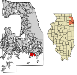
Location of University Park in Will County and Cook County, Illinois.
|
||
| Country | ||
| State | Illinois | |
| Counties | Cook, Will | |
| Townships | Monee, Crete, Rich | |
| Incorporated | 1967 | |
| Government | ||
| • Type | Council–manager | |
| Area | ||
| • Total | 10.73 sq mi (27.79 km2) | |
| • Land | 10.73 sq mi (27.78 km2) | |
| • Water | 0.00 sq mi (0.01 km2) 0% | |
| Population
(2020)
|
||
| • Total | 7,145 | |
| • Density | 666.08/sq mi (257.18/km2) | |
| Standard of living (2007–11) | ||
| • Per capita income | $20,083 | |
| • Median home value | $49,400 | |
| ZIP code(s) |
60484, 60478
|
|
| Area code(s) | 708/464 | |
| Geocode | 76935 | |
| FIPS code | 17-76935 | |
University Park is a village in Illinois, a state in the United States. Most of it is in Will County, with a small part in Cook County. It is a southern suburb of Chicago.
This village is special because it was one of the few "planned communities" in the area. It was created in the 1960s. First, it was called Wood Hill, then Park Forest South, and finally University Park. Governors State University opened here in 1969. In 2020, about 7,145 people lived in the village.
Contents
History of University Park
In the late 1950s, a company called Woodhill Enterprises bought land south of Park Forest. They planned to build many homes. Construction started in 1961. By 1967, only 240 homes were built in the area known as Wood Hill. The people living there formed a group to help build a strong community.
In 1966, Nathan Manilow, who helped develop Park Forest, began buying more land around Wood Hill. His son, Lewis Manilow, created a new company called New Community Enterprises (NCE). Their goal was to build a "whole new town." Other big partners included Illinois Central Industries.
NCE helped officially create Park Forest South in 1967. They hoped 100,000 people would live there one day. Under a special government program in 1968, Park Forest South became one of 15 "new communities." The plan for the town included areas for homes, shops, and businesses. It also made sure there was space for schools, parks, and places of worship. A key goal was to welcome people of all races, and Park Forest South became a leader in fair housing.
Governors State University opened its doors in 1969. The Illinois Central Railroad extended its train line to the village. This made University Park the last stop on the Metra Electric District train line. The original plan for the town also included wooded areas and places for fun and sports.
The people who developed the town and the village leaders had big dreams. In 1970, the state of Illinois gave $24 million for the university campus. In 1971, the government helped with $30 million in loans to make the vision happen.
The developers also improved the water and sewage systems. In 1970, they opened the first elementary school, the first apartment buildings, and a business park.
However, the economy faced problems, and the government program had issues. The village did not grow as fast as planned. In late 1974, development stopped for a while. For over two years, many people worked hard to fix these problems. The new town, which was meant for 100,000 people, changed its plan. It would now grow slowly, expecting 20,000 to 25,000 residents. By 2000, the population was 6,662.
Even today, you can see the original town planning. The business park near Interstate 57 is an important part of the village. Residential areas still have open spaces and bike paths. The village's history includes the Nathan Manilow Sculpture Park. This is a famous outdoor art park at Governors State University. Lewis Manilow created it to honor his father.
Notable People from University Park
- Amara Enyia (born 1982), a political strategist. She grew up in University Park.
- Shonda Rhimes, a famous television producer and writer. She created popular TV shows like Grey's Anatomy and Scandal. She lived in University Park (then called Park Forest South) as a child.
- Chris Slayton (born 1996), a football player. He lived in University Park when he was a child.
Education in University Park
The village of University Park is part of the Crete-Monee Community Unit School District 201-U. Coretta Scott King Magnet Elementary School is located in the village. Crete-Monee Middle School is also in University Park.
Geography of University Park
University Park is located at 41°26′22″N 87°41′50″W / 41.43944°N 87.69722°W.
The village covers about 10.73 square miles (27.79 square kilometers). Almost all of this area is land. University Park sits on the Valparaiso Moraine. This is a ridge of hills that also marks the Eastern Continental Divide. This means that water on one side flows to the Atlantic Ocean, and water on the other side flows to the Gulf of Mexico.
Surrounding Areas
- Richton Park
- Richton Park


 Park Forest
 - Frankfort / Unincorporated Will County

 Steger / Crete
 - Unincorporated Will County


 Unincorporated Will County
 - Monee / Unincorporated Will County
Population and People
| Historical population | |||
|---|---|---|---|
| Census | Pop. | %± | |
| 1970 | 1,748 | — | |
| 1980 | 6,245 | 257.3% | |
| 1990 | 6,204 | −0.7% | |
| 2000 | 6,662 | 7.4% | |
| 2010 | 7,129 | 7.0% | |
| 2020 | 7,145 | 0.2% | |
| U.S. Decennial Census 2010 2020 |
|||
In 2020, there were 7,145 people living in University Park. There were 2,508 households and 1,831 families. The village had about 666 people per square mile. There were 2,756 homes.
Most of the people in the village were African American (87.64%). About 5.16% were White. Other groups included Native American, Asian, and people of two or more races. About 4.04% of the population was Hispanic or Latino.
In the households, 49.2% had children under 18. About 33.69% were married couples. About 32.18% were single mothers. The average household had 3.37 people.
The median age in the village was 30.6 years old. About 32.0% of the people were under 18. About 10.3% were 65 or older.
The median income for a household was $62,258. For a family, it was $63,551. The average income per person was $23,354. About 10.3% of the people lived below the poverty line. This included 13.2% of those under 18.
| Race / Ethnicity (NH = Non-Hispanic) | Pop 2010 | Pop 2020 | % 2010 | % 2020 |
|---|---|---|---|---|
| White alone (NH) | 392 | 346 | 5.50% | 4.84% |
| Black or African American alone (NH) | 6,362 | 6,199 | 89.24% | 86.76% |
| Native American or Alaska Native alone (NH) | 6 | 14 | 0.08% | 0.20% |
| Asian alone (NH) | 59 | 18 | 0.83% | 0.25% |
| Pacific Islander alone (NH) | 1 | 0 | 0.01% | 0.00% |
| Some Other Race alone (NH) | 3 | 49 | 0.04% | 0.69% |
| Mixed Race or Multi-Racial (NH) | 128 | 230 | 1.80% | 3.22% |
| Hispanic or Latino (any race) | 178 | 289 | 2.50% | 4.04% |
| Total | 7,129 | 7,145 | 100.00% | 100.00% |
Getting Around University Park
University Park has a train station for the Metra Electric District line. This is the last stop on that line. Other trains, like the City of New Orleans and Illini and Saluki, pass through but do not stop.
The station also offers bus services. Pace route 367 and the River Valley Metro's University Park route serve the area.
Pace buses on Route 367 connect University Park to Park Forest and other places.
Stuenkel Road helps connect Interstate 57 to University Park. Illinois Route 50 is another main road that goes through the village.
See also
 In Spanish: University Park (Illinois) para niños
 | Frances Mary Albrier |
 | Whitney Young |
 | Muhammad Ali |


