Chicago Loop facts for kids
Quick facts for kids
The Loop
|
|
|---|---|
| Community Area 32 – The Loop | |
 |
|
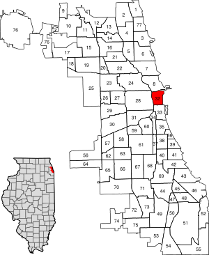
Location within the city of Chicago
|
|
| Country | United States |
| State | Illinois |
| County | Cook |
| City | Chicago |
| Neighborhoods |
List
|
| Area | |
| • Total | 1.58 sq mi (4.09 km2) |
| Elevation | 594 ft (181 m) |
| Population
(2020)
|
|
| • Total | 42,298 |
| • Density | 26,790/sq mi (10,342/km2) |
| population up 158.1% from 2000 | |
| Demographics 2021 | |
| • White | 56.7% |
| • Black | 8.1% |
| • Hispanic | 10.4% |
| • Asian | 20.9% |
| • Other | 4.0% |
| Educational Attainment 2021 | |
| • High School Diploma or Higher | 97.3% |
| • Bachelor's Degree or Higher | 82.2% |
| Time zone | UTC-6 (CST) |
| • Summer (DST) | UTC-5 (CDT) |
| ZIP codes |
60601, 60602, 60603, 60604, and parts of 60605, 60606, 60607, and 60616
|
| Median household income 2021 | 5,988 |
| Source: U.S. Census, Record Information Services | |
The Loop is one of Chicago's 77 official community areas. It is the main downtown area and the central business district of the city. The Loop is the second largest business district in North America, after Midtown Manhattan in New York City.
This area is home to many important things. You'll find headquarters for big companies, lots of shops, restaurants, hotels, and theaters. Many of Chicago's most famous attractions are also here. The Loop is where Chicago's City Hall is located, along with offices for Cook County and other government groups.
The intersection of State Street and Madison Street is special. It's the starting point for all addresses in Chicago's street grid. Most of Grant Park, a huge green space, is in the eastern part of the Loop. The Loop is surrounded by the Chicago River to the north and west, Lake Michigan to the east, and Roosevelt Road to the south.
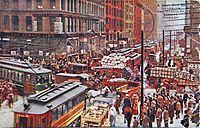
In 1803, the United States Army built Fort Dearborn in what is now the Loop. This was the first settlement in the area supported by the U.S. government. When Chicago was officially started in the 1830s, this area became the center for the city and county governments. At first, it had a mix of uses, but it became mostly commercial in the 1870s. This happened especially after the Great Chicago Fire of 1871 destroyed much of it.
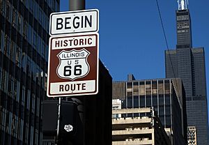
After the fire, some of the world's first skyscrapers were built here. This started a tradition of amazing architecture that continues today. In the late 1800s, special tracks for cable cars and a famous elevated railway loop went around the area. This is how "The Loop" got its name! In the 1920s, many highways were built, including U.S. Route 66, which ended here.
Even though the Loop is mostly offices and public buildings, more and more people have moved to live here. Its population has grown a lot since the 1950s.
Contents
History of the Loop
How the Loop Got Its Name
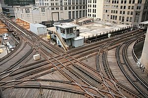
The name "Loop" comes from the way public transportation was set up. Some people think it came from the cable car lines that used a loop in 1882. This loop was bounded by Van Buren Street, Wabash Avenue, Wells Street, and Lake Street.
However, other research suggests the name "the Loop" became popular after the elevated railway loop was built between 1895 and 1897. This elevated train system circled the downtown area, making the name stick.
Early Days: The 1800s
In 1803, the United States Army built Fort Dearborn on the south bank of the Chicago River. This was the first U.S. settlement in the area. When Chicago was first planned in 1830, it included what is now the northern and western parts of the Loop.
The first hotel in Chicago, the Sauganash Hotel, was built in 1831. When Cook County was formed in 1831, its first government meeting was held at Fort Dearborn. By the late 1830s, the area was very busy. Lake Street was a main shopping area, but State Street became more important for shopping in the 1850s.
The Loop in the 1900s and 2000s
By 1948, about one million people came to the Loop every day for work or other activities. Later, as people moved to the suburbs, the Loop's importance decreased a bit. But starting in the 1960s, new fancy shopping areas helped the Loop become popular again.
In recent years, the number of people living in the Loop has grown a lot. Between 2000 and 2020, the population increased by 158 percent! Also, the number of jobs in the Loop grew by over 13% between 2010 and 2014.
Economy and Jobs
The Loop is a major center for business in the United States. It is the second largest commercial business district after Midtown Manhattan in New York City. The financial area near LaSalle Street is home to major companies like United Airlines and Hyatt Hotels & Resorts. It also has the CME Group, which includes the Chicago Board of Trade and Chicago Mercantile Exchange.
Many large companies have offices or headquarters in the Loop. For example, Aon Corporation is in the Aon Center. Exelon has its main office in Chase Tower. United Airlines moved its headquarters to Willis Tower in 2007. The Blue Cross and Blue Shield Association is in the Michigan Plaza complex.
The Loop is also home to many business organizations. These include the Chicago Loop Alliance and the Chicagoland Chamber of Commerce.
In 2019, about 40% of people who lived in the Loop also worked there. Many people who work in the Loop live outside of Chicago. The most common types of jobs in the Loop are in professional services and finance.
Amazing Architecture
The Loop is famous for its architecture. Most of the area was destroyed by the Great Chicago Fire in 1871. But it was rebuilt very quickly. In 1885, the Home Insurance Building was constructed. Many people consider this to be the world's first skyscraper!
After that, the Chicago school of architecture developed. Famous buildings from this time include the Rookery Building (1888), the Monadnock Building (1891), and the Sullivan Center (1899).
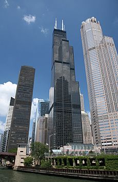
Since its early days, the Loop has been filled with skyscrapers and tall buildings. Some important buildings include the Chicago Board of Trade Building, which is a National Historic Landmark. The Willis Tower (formerly Sears Tower) was the world's tallest building for almost 25 years. These historic buildings helped shape how tall towers are built today.
The Loop offers many shopping places, especially in the Loop Retail Historic District. You can find Chicago's former Marshall Field's department store, now Macy's, in the Marshall Field and Company Building. The original Sullivan Center (formerly Carson Pirie Scott) store was also here.
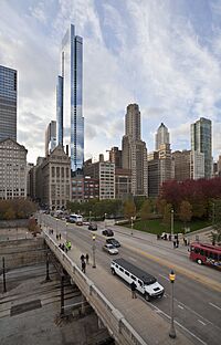
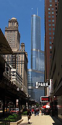
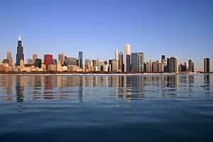
Chicago's Downtown Theatre District is in the Loop. There are also many restaurants and hotels. The city has a famous skyline with many tall buildings. The Willis Tower is in the western part of the Loop. Other tall buildings include 311 South Wacker Drive and the AT&T Corporate Center.
The Aon Center, Chicago's fourth tallest building, is located near Illinois Center. This area is at the east end of the Loop, near Michigan Avenue. Two Prudential Plaza is also nearby.
The Loop has many outdoor sculptures by famous artists like Pablo Picasso and Joan Miró. It's also home to major cultural places. These include the Art Institute of Chicago, the Goodman Theatre, the Chicago Theatre, the Lyric Opera, and the Chicago Symphony Orchestra. The historic Palmer House Hilton hotel is also here.
Chicago's waterfront has beautiful parks and beaches. Grant Park is downtown. It features Buckingham Fountain, the Petrillo Music Shell, and free summer concerts by the Grant Park Symphony. Grant Park also hosts the annual Taste of Chicago food festival and the music festival Lollapalooza.
Millennium Park is part of Grant Park. It opened in 2004 and has amazing art and architecture. You can see Frank Gehry's Jay Pritzker Pavilion, Jaume Plensa's Crown Fountain, and Anish Kapoor's Cloud Gate sculpture (often called "The Bean").
The Chicago River and its Chicago Riverwalk offer fun activities. Every year, the river is dyed green for St. Patrick's Day. You can also take boat tours of the Chicago River to learn about the city's architecture.
Famous Landmarks in the Loop
- Agora – a group of sculptures in Grant Park.
- Art Institute of Chicago
- Auditorium Building
- Buckingham Fountain
- Carbide & Carbon Building
- Carson, Pirie, Scott and Company Building
- Chicago Board of Trade Building
- Chicago Theatre
- Chicago Cultural Center
- Chicago City Hall
- Civic Opera House
- Fine Arts Building
- Grant Park
- Jewelers Row District
- Historic Michigan Boulevard District
- Monadnock Building
- The Palmer House Hilton
- Printing House Row
- Reliance Building
- Rookery Building
- Symphony Center – home of the Chicago Symphony Orchestra
- Willis Tower – formerly the Sears Tower
Getting Around: Transportation
The Loop gets its name from the transportation systems that circle it.
Public Transportation
By the 1890s, train lines reached many stations in the Loop. The building of a streetcar loop in 1882 and the elevated railway loop in the 1890s gave the area its name. These systems made the Loop the most important part of the city.
Today, several train lines serve the Loop. The Metra Electric District line and the Rock Island District line have their main stations here. The South Shore Line, which goes to South Bend, Indiana, also starts at Millennium Station in the Loop.
Almost all lines of the Chicago "L" train system go through the Loop. The State Street Subway (part of the Red Line) and the Dearborn Street Subway (part of the Blue Line) run through the Loop. These lines are open 24 hours a day, 7 days a week! There are also special Bus Rapid Transit lines in the Loop.
Driving and Roads
Since 1909, Chicago's address system has started at the intersection of State and Madison Streets. Before that, addresses were confusing because Chicago had grown by adding many smaller towns.
Some streets in the Loop have multiple levels, sometimes as many as three! Wacker Drive, which runs along the Chicago River, is a good example. The Illinois Center neighborhood also has three-level streets. This helps keep traffic flowing.
The famous U.S. Route 66, an iconic highway, used to end at Jackson Boulevard and Michigan Avenue in the Loop. The "END OF ROUTE 66" sign was a well-known landmark.
The Loop is a very walkable area. Many people who live or work here walk or bike to get around. About 33% of Loop residents walk or bike to work. Another 19% use public transportation. Only about 22% of Loop residents drive to work alone or in a carpool. Also, nearly half of Loop residents don't own a car at all!
Neighborhoods and Geography
The Loop is Community Area 32. Besides the main financial, theater, and jewelry areas, there are several neighborhoods within the Loop community area.
New Eastside
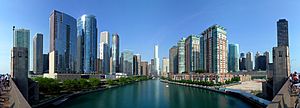
The New Eastside is a mixed-use area with homes and businesses. It's bordered by Michigan Avenue to the west, the Chicago River to the north, Randolph Street to the south, and Lake Shore Drive to the east. This area includes Illinois Center and Lakeshore East. Many buildings here, like the Aon Center, were built over old railroad yards.
The New Eastside has a special triple-level street system. This means trucks can use lower levels for deliveries, keeping traffic smoother on the upper levels.
Printer's Row
Printer's Row is a neighborhood in the southern part of the Loop. It's centered around Dearborn Street. Most buildings here were built between 1886 and 1915 for printing and publishing businesses. Today, many of these old buildings have been turned into homes called lofts. Part of Printer's Row is a special landmark district. Every June, the annual Printers Row Lit Fest is held here, celebrating books and reading.
South Loop
The area south of Ida B. Wells Drive, between Lake Michigan and the Chicago River, is called the South Loop (except for Chinatown). This neighborhood has grown a lot. Old railroad yards have been turned into new housing developments like Dearborn Park. Former warehouses and factories are now residential buildings. New townhouses and tall buildings have also been built.
Dearborn Station, at the south end of Printers Row, is Chicago's oldest train station still standing. It has been turned into shops and offices. Columbia College Chicago, a private school, owns many buildings in the South Loop.
Historic Michigan Boulevard District
The Loop also includes the Chicago Landmark Historic Michigan Boulevard District. This is the section of Michigan Avenue that faces Grant Park and Millennium Park. It's known for its beautiful historic buildings.
You can find historical images and current architecture of the Chicago Loop on Explore Chicago Collections. This is a digital library from Chicago's archives and cultural places.
Loop Retail Historic District
The Loop Retail Historic District is a shopping area in the Chicago Loop. It's bounded by Lake Street, Ida B. Wells Drive, State Street, and Wabash Avenue. This district has the most historic buildings in Chicago, including former major department stores like Marshall Field and Company Building (now Macy's) and the Sullivan Center.
Education in the Loop
Colleges and Universities
Many colleges and universities have campuses in the Loop. These include Columbia College Chicago, Roosevelt University, and DePaul University. The University of Illinois at Urbana–Champaign and University of Notre Dame also have programs here.
National-Louis University is in the historic Peoples Gas Building on Michigan Avenue. The School of the Art Institute of Chicago, a large art and design school, is headquartered in Grant Park.
Harold Washington College is a community college located in the Loop. Other colleges here include Adler School of Professional Psychology, Argosy University, and Harrington College of Design. Trinity Christian College offers a teaching program here.
Spertus Institute, a center for Jewish learning, is on S. Michigan Ave. Meadville Lombard Theological School, a seminary, is on North Wabash Avenue. East-West University is also located in the Loop.
Schools for Kids
Chicago Public Schools serves children living in the Loop. Some students go to South Loop School, while others go to the Ogden International School for grades K-8. For high school, some students are zoned to Phillips Academy High School or Wells Community Academy High School.
Jones College Prep High School is a public selective enrollment school in the Loop. This means students from all over the city can apply to attend. Muchin College Prep, a charter school, is also located on State Street.
There are also private schools in the Loop:
- British International School of Chicago, South Loop
- GEMS World Academy-Chicago
Parks and Fun Places
The Loop has several great parks for everyone to enjoy.
Chicago Riverwalk
The Chicago Riverwalk is a beautiful path along the southern edge of the Chicago River. It's a great place to walk, relax, and enjoy views of the city.
Grant Park
Grant Park is a large park located right on the shores of Lake Michigan. It was set aside in the late 1800s and was first called "Lake Park." It was later renamed after Ulysses Grant, a Civil War general and U.S. President. Buckingham Fountain, a famous landmark, was built in Grant Park in 1927.
Maggie Daley Park
Maggie Daley Park is a fun park located just east of Millennium Park. It has unique play areas, a climbing wall, and a skating ribbon.
Millennium Park
Millennium Park is located northwest of Grant Park. It was planned to celebrate the new millennium but opened in 2004. It's famous for its modern art and architecture, including "The Bean" sculpture.
Printer's Row Park
This park, also known as Park No. 543, is in the Printer's Row neighborhood. It has a community garden and a pretty fountain.
Pritzker Park
Pritzker Park is on State Street, near the Harold Washington Library. It's a green space with a wall that has quotes from famous writers and thinkers.
Theodore Roosevelt Park
Theodore Roosevelt Park is in the South Loop. It's named after U.S. President Theodore Roosevelt. This park has open spaces and tennis courts. It's located on Roosevelt Road, which is also named after him.
See also
 In Spanish: Chicago Loop para niños
 | Kyle Baker |
 | Joseph Yoakum |
 | Laura Wheeler Waring |
 | Henry Ossawa Tanner |


