Hinsdale, Illinois facts for kids
Quick facts for kids
Hinsdale, Illinois
|
||
|---|---|---|
|
Village
|
||
| Village of Hinsdale | ||
 |
||
|
||

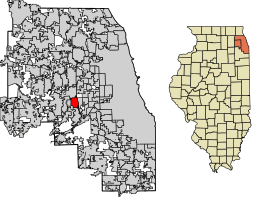
Location of Hinsdale in DuPage County and Cook County, Illinois.
|
||
| Country | United States | |
| State | Illinois | |
| Counties | Cook, DuPage | |
| Townships | Downers Grove, York, Lyons, Proviso | |
| Incorporated | April 1, 1873 | |
| Government | ||
| • Type | Council–manager | |
| Area | ||
| • Total | 4.66 sq mi (12.07 km2) | |
| • Land | 4.62 sq mi (11.97 km2) | |
| • Water | 0.04 sq mi (0.10 km2) 0.65% | |
| Population
(2020)
|
||
| • Total | 17,395 | |
| • Density | 3,763/sq mi (1,452.75/km2) | |
| Down 3.07% from 2000 | ||
| Standard of living (2015-2019) | ||
| • Per capita income | $114,121 | |
| • Median home value | $969,219 | |
| ZIP code(s) |
60521
|
|
| Area code(s) | 630 and 331 | |
| Geocode | 35307 | |
| FIPS code | 17-35307 | |
Hinsdale is a village in Illinois, a state in the United States. It's mostly in DuPage County, but a small part is in Cook County. Hinsdale is known as a wealthy community and is a western suburb of Chicago. In 2020, about 17,395 people lived there.
Contents
Where is Hinsdale Located?
Hinsdale is about 20 miles (32 km) west of Chicago. It shares borders with several other towns. To the north is Oak Brook, and to the south are Burr Ridge and Willowbrook. On the east side is Western Springs, and to the west are Clarendon Hills and Westmont.
The village covers a total area of about 4.66 square miles (12.07 km2). Most of this area, about 4.62 square miles (11.97 km2), is land. A small part, about 0.04 square miles (0.10 km2), is water.
Who Lives in Hinsdale?
| Historical population | |||
|---|---|---|---|
| Census | Pop. | %± | |
| 1880 | 819 | — | |
| 1890 | 1,584 | 93.4% | |
| 1900 | 2,578 | 62.8% | |
| 1910 | 2,451 | −4.9% | |
| 1920 | 4,042 | 64.9% | |
| 1930 | 6,923 | 71.3% | |
| 1940 | 7,336 | 6.0% | |
| 1950 | 8,676 | 18.3% | |
| 1960 | 12,859 | 48.2% | |
| 1970 | 15,918 | 23.8% | |
| 1980 | 16,726 | 5.1% | |
| 1990 | 16,029 | −4.2% | |
| 2000 | 17,349 | 8.2% | |
| 2010 | 16,816 | −3.1% | |
| 2020 | 17,395 | 3.4% | |
| U.S. Decennial Census | |||
In 2020, Hinsdale had 17,395 people living in 5,809 households. About 4,817 of these were families. The village had about 3,732 people per square mile.
Most residents, about 77.33%, were White. About 12.44% were Asian, and 1.67% were African American. People from two or more races made up 7.09% of the population. About 5.45% of the people were Hispanic or Latino.
Many households (50.4%) had children under 18 living with them. Most families (75.02%) were married couples. The average household had 3.30 people. The average family had 2.94 people.
The median age in Hinsdale was 42.3 years. About 32.2% of the population was under 18. About 13.6% were 65 years or older.
The median income for a household was $206,701. For families, it was $244,598. The per capita income for the village was $106,061. This means the average income per person was very high. Only a small number of families (0.5%) and people (1.9%) lived below the poverty line.
Historic Buildings and Architecture
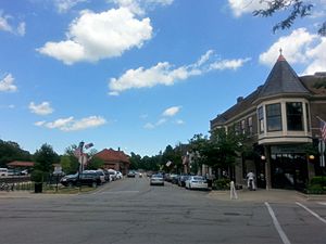
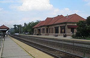
Hinsdale has a special downtown area. It is listed on the National Register of Historic Places. This means it's an important historical site. The downtown area has many shops, restaurants, and the main train station. It still looks much like it did a long time ago.
Another historic area is the Robbins Park district. It also has buildings listed on the National Register of Historic Places. Some of these buildings are:
- The Orland P. Bassett House at 329 E. Sixth St.
- The Robert A. and Mary Childs House at 318 S. Garfield Ave.
- Immanuel Evangelical Church at 302 S. Grant St.
- The Francis Stuyvesant Peabody House at 8 E. Third St.
- The William Whitney House at 142 E. First St.
A special building is the R. Harold Zook Home and Studio. It was moved in 2005 to Katherine Legge Memorial Park to save it from being torn down.
The Hinsdale Historical Society helps protect these old buildings. They have the Roger & Ruth Anderson Architecture Center. It works to save Hinsdale's historic architecture and keeps records about it.
Getting Around Hinsdale
Roads and Highways
Hinsdale has many important roads. These include the Tri-State Tollway (Interstate 294), U.S. Route 34, and Illinois Route 83. These roads help people travel easily.
Train and Bus Services
Hinsdale is served by Metra's BNSF Line train. There are three train stations in Hinsdale: Highlands, Hinsdale, and West Hinsdale.
Also, Pace buses run in Hinsdale. Bus lines 663 and 668 help people get around town.
Schools and Learning
Local Schools
Students in Hinsdale attend schools in two main districts. These are Community Consolidated School District 181 for younger students and the Hinsdale Township High School District 86 for high schoolers. The high school district's main office is in Hinsdale.
Elementary schools in Hinsdale include The Lane School, Madison School, Monroe School, and Oak School. Hinsdale Middle School is also in Hinsdale. Hinsdale Central High School is the main high school in the village. There is also a Catholic school called St Isaac Jogues for grades K-8.
Public Library
The Hinsdale Public Library is located in the Memorial Building. It first opened in August 1893. The Memorial Building became the library's permanent home in 1929. A donation helped fund an addition to the library in 1957. In 1988, the library got another addition and swapped places with the village administration offices.
Working in Hinsdale
Many people who live in Hinsdale travel to jobs in the wider Chicago area. However, Hinsdale also has many small and medium-sized businesses.
Some non-profit groups are also based here. These include the Hinsdale Historical Society and the Hinsdale Humane Society.
Main Employers
Here are some of the biggest employers in Hinsdale:
| # | Employer | # of Employees |
|---|---|---|
| 1 | UChicago Medicine AdventHealth Hinsdale Hospital | 1,555 |
| 2 | RML Specialty Hospital | 800 |
| 3 | Hinsdale Township High School District 86 | 620 |
| 4 | Community Consolidated School District 181 | 550 |
| 5 | CWT | 220 |
| 6 | Coldwell Banker | 150 |
Parks and Fun Activities
Hinsdale has many parks and places for recreation.
Katherine Legge Memorial Park
The Katherine Legge Memorial Park and Lodge is a large 52 acres (21 ha) woodland area. It was given to the Village of Hinsdale in 1973. The lodge building, built in 1927, can be rented for parties and events. The park has:
- A clubhouse with meeting rooms
- A football/soccer field
- A picnic area
- Playground equipment
- Open green spaces
- A frisbee golf course
- A sledding hill for winter fun
- Four platform tennis courts
Other Parks and Facilities
- The Hinsdale Community Swimming Pool is the village's public pool. It covers 3-acre (1.2 ha).
- Veeck Park is 14.7-acre (5.9 ha) and has a skate park, baseball field, soccer fields, and a playground.
- Brook Park is 8.3-acre (3.4 ha) with a ball field, soccer field, playground, and tennis courts.
- Burns Field is 6.55-acre (2.65 ha) and offers ice skating, a picnic area, playground, and tennis courts.
- Pierce Park is 8.82-acre (3.57 ha) with a ball field, soccer field, picnic area, playground, and tennis courts.
- Robbins Park is 14.50-acre (5.87 ha) and has a football/soccer field, playground, and tennis courts.
- Stough Park is 2.33-acre (0.94 ha) with ice skating, a playground, and tennis courts.
Many other smaller parks offer scenic open spaces or playgrounds for everyone to enjoy.
Famous People from Hinsdale
To learn about famous people who are from Hinsdale, you can visit the List of people from Hinsdale, Illinois page.
See also
 In Spanish: Hinsdale (Illinois) para niños
 | Claudette Colvin |
 | Myrlie Evers-Williams |
 | Alberta Odell Jones |


