Clarendon Hills, Illinois facts for kids
Quick facts for kids
Clarendon Hills, Illinois
|
|
|---|---|
|
Village
|
|
| Village of Clarendon Hills | |

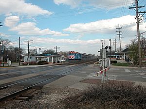
Clarendon Hills Station in 2004
|
|
| Nickname(s):
The Volunteer Village
|
|

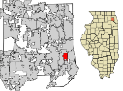
Location of Clarendon Hills in DuPage County, Illinois.
|
|
| Country | |
| State | Illinois |
| County | DuPage |
| Township | Downers Grove |
| Incorporated | 1924 |
| Founded by | Henry Middaugh |
| Government | |
| • Type | Council–manager |
| Area | |
| • Total | 1.82 sq mi (4.71 km2) |
| • Land | 1.81 sq mi (4.69 km2) |
| • Water | 0.01 sq mi (0.03 km2) 0.55% |
| Elevation | 728 ft (222 m) |
| Population
(2020)
|
|
| • Total | 8,702 |
| • Density | 4,808/sq mi (1,856.10/km2) |
| Standard of living | |
| • Per capita income | $58,298 |
| • Home value | $569,700 |
| ZIP code(s) |
60514
|
| Area code(s) | 630 and 331 |
| Geocode | 17-14572 |
| FIPS code | 17-14572 |
Clarendon Hills is a village in DuPage County, Illinois, United States. It's a suburb located southwest of Chicago. In 2020, about 8,702 people lived there.
Contents
History of Clarendon Hills
The area where Clarendon Hills is now used to be a wide, grassy prairie. Unlike many older villages nearby, Clarendon Hills was planned to look like a park. It has winding streets that follow the natural shape of the land. This is different from towns with straight streets.
The village was officially created, or incorporated, in 1924. At that time, fewer than 900 people lived there. The main reason it became its own village was to avoid being taken over by the nearby community of Hinsdale.
The Clarendon Hills Historical Society works to keep the town's history alive. They plan to create a community center and a museum. This museum will show important items from the village's past.
In 1961, a plane crash happened in Clarendon Hills. Sadly, all 73 people on board lost their lives. On May 11, 2022, a Metra train hit a truck near Prospect Avenue. One person died in this accident.
Geography of Clarendon Hills
Clarendon Hills is located at 41°47′46″N 87°57′21″W / 41.79611°N 87.95583°W. It is about 18 miles southwest of Chicago.
The village covers about 1.82 square miles (4.71 square kilometers). Most of this area, about 1.81 square miles (4.69 square kilometers), is land. A very small part, about 0.01 square miles (0.03 square kilometers), is water.
| Climate data for Clarendon Hills, Illinois | |||||||||||||
|---|---|---|---|---|---|---|---|---|---|---|---|---|---|
| Month | Jan | Feb | Mar | Apr | May | Jun | Jul | Aug | Sep | Oct | Nov | Dec | Year |
| Record high °F (°C) | 65 (18) |
71 (22) |
88 (31) |
91 (33) |
93 (34) |
104 (40) |
102 (39) |
100 (38) |
99 (37) |
91 (33) |
78 (26) |
71 (22) |
104 (40) |
| Mean daily maximum °F (°C) | 31 (−1) |
35 (2) |
47 (8) |
59 (15) |
70 (21) |
80 (27) |
83 (28) |
82 (28) |
75 (24) |
63 (17) |
49 (9) |
36 (2) |
59 (15) |
| Mean daily minimum °F (°C) | 16 (−9) |
18 (−8) |
28 (−2) |
38 (3) |
49 (9) |
59 (15) |
63 (17) |
62 (17) |
54 (12) |
43 (6) |
32 (0) |
21 (−6) |
40 (4) |
| Record low °F (°C) | −27 (−33) |
−17 (−27) |
−8 (−22) |
7 (−14) |
24 (−4) |
36 (2) |
40 (4) |
41 (5) |
28 (−2) |
17 (−8) |
1 (−17) |
−25 (−32) |
−27 (−33) |
| Average precipitation inches (mm) | 2.07 (53) |
1.76 (45) |
2.44 (62) |
3.78 (96) |
4.39 (112) |
4.61 (117) |
4.15 (105) |
4.03 (102) |
3.31 (84) |
3.30 (84) |
2.60 (66) |
2.20 (56) |
38.64 (981) |
| Average snowfall inches (cm) | 11.0 (28) |
8.0 (20) |
7.0 (18) |
2.0 (5.1) |
0 (0) |
0 (0) |
0 (0) |
0 (0) |
0 (0) |
0.1 (0.25) |
2.0 (5.1) |
9.0 (23) |
39.1 (99) |
People in Clarendon Hills
| Historical population | |||
|---|---|---|---|
| Census | Pop. | %± | |
| 1880 | 69 | — | |
| 1930 | 933 | — | |
| 1940 | 1,281 | 37.3% | |
| 1950 | 2,437 | 90.2% | |
| 1960 | 5,885 | 141.5% | |
| 1970 | 6,750 | 14.7% | |
| 1980 | 6,870 | 1.8% | |
| 1990 | 6,994 | 1.8% | |
| 2000 | 7,610 | 8.8% | |
| 2010 | 8,427 | 10.7% | |
| 2020 | 8,702 | 3.3% | |
| U.S. Decennial Census | |||
In 2020, there were 8,702 people living in Clarendon Hills. There were 3,431 households, which are groups of people living together. The population density was about 4,781 people per square mile.
Most people in the village, about 80.66%, were White. About 8.47% were Asian, and 1.47% were African American. People of Hispanic or Latino background made up about 5.96% of the population.
About 43.5% of households had children under 18 living with them. Most households (61.18%) were married couples. The average household had about 3.30 people.
The median age in the village was 41.3 years old. This means half the people were younger and half were older than 41.3. About 31.8% of the population was under 18.
The median income for a household was $103,486. This is the middle income for all households. For families, the median income was $175,801. About 8.6% of the people in the village were living below the poverty line.
Transportation
Clarendon Hills has a train station for the Metra BNSF Line. This train line offers daily service between Aurora, Illinois and Chicago, Illinois (at Union Station).
Also, Pace provides bus services that connect to the train. Bus lines 663 and 664 serve Clarendon Hills.
Schools in Clarendon Hills
Clarendon Hills is part of Community Consolidated School District 181. This district includes:
- Clarendon Hills Middle School (for grades 6–8)
- Prospect School (for grades K-5)
- Walker School (for grades K-5)
Dr. Don White is the superintendent of these schools. There is also a private school, Notre Dame Parish School, for grades PK-8. Some parts of Clarendon Hills are also in Maercker District 60, which has Holmes School (grades K-2), Maercker School (grades 3–6), and Westview Hills Middle School (grades 6–8).
Clarendon Hills Middle School (CHMS) is one of two middle schools in District 181. It is one of five public middle schools that send students to Hinsdale Central High School. In the 2009–10 school year, about 700 students attended CHMS. The Chicago Tribune newspaper ranked CHMS as the 14th best middle school in Illinois based on test scores. More than 96% of students met or went beyond the state's learning standards.
In 2009, Clarendon Hills Middle School received a Blue Ribbon award from the United States Department of Education. This award recognizes it as one of the best schools in the country. CHMS is ranked among the top 2% of middle schools in Illinois.
In 2009–10, Prospect School had about 449 students, and Walker School had about 305 students. All three schools (CHMS, Prospect, and Walker) are rated 10 out of 10 by greatschools.net, which is a website that rates schools.
Notable People
- Bill Evans, a jazz musician
- Emily Montague Schwartz, a member of the Symbionese Liberation Army
- Bill Laimbeer, a former basketball player who won NBA championships with the Detroit Pistons
- Ben Murphy, an actor
- Brian Wardle, a basketball head coach for Bradley University
See also
 In Spanish: Clarendon Hills para niños
 | Sharif Bey |
 | Hale Woodruff |
 | Richmond Barthé |
 | Purvis Young |

