
Westmont, Illinois facts for kids
Quick facts for kids
Westmont
|
|||
|---|---|---|---|
|
Village
|
|||

|
|||
|
|||
| Nickname(s):
"Whiskey Hill", "Wet-mont", "Bestmont"
|
|||
| Motto(s):
"The Progressive Village", "In The Middle Of It All"
|
|||

Location of Westmont in DuPage County, Illinois.
|
|||
| Country | |||
| State | Illinois | ||
| County | DuPage | ||
| Township | Downers Grove, York | ||
| Incorporated | 1921 | ||
| Government | |||
| • Type | Mayor-trustee | ||
| Area | |||
| • Total | 5.11 sq mi (13.23 km2) | ||
| • Land | 5.00 sq mi (12.96 km2) | ||
| • Water | 0.10 sq mi (0.27 km2) 2.14% | ||
| Population
(2020)
|
|||
| • Total | 24,429 | ||
| • Density | 4,881.89/sq mi (1,884.88/km2) | ||
| Up 15.67% from 1990 | |||
| Standard of living | |||
| • Per capita income | $26,394 (median: $51,422) | ||
| • Home value | $200,814 (median: $180,200 (2000)) | ||
| ZIP code(s) |
60559
|
||
| Area code(s) | 630 and 331 | ||
| Geocode | 80645 | ||
| FIPS code | 17-80645 | ||


| Demographic | Proportion |
|---|---|
| White | 78.02% |
| Black | 6.38% |
| Hispanic | 6.98% |
| Asian | 11.95% |
| Islander | 0.00% |
| Native | 0.13% |
| Other | 2.41% |
Westmont is a village located in DuPage County, Illinois, United States. It is a community of about 5 square miles. In 2020, its population was 24,429 people. Westmont is a suburb found southwest of the big city of Chicago.
Contents
Westmont's Early Days: A Look at Its History
The land where Westmont now stands was once home to the Potawatami people. The U.S. government tried to get the Native Americans to leave the area. In 1833, they finally agreed to move after being pressured.
How the Canal Helped Westmont Grow
In the 1820s, Illinois planned to build the Illinois-Michigan Canal. This canal was meant to help transport goods. Construction was delayed until the 1830s. Many workers on the canal later became farmers when money problems halted the work. Farming became very important, and crops were sold in nearby Chicago. The area around Westmont became one of the richest parts of the state.
Roads and Railroads: Connecting Westmont
To get farm products to Chicago, a special road was built starting in 1840. This road was made of planks (flat pieces of wood). It went through a swamp between Chicago and what would become Westmont. By 1851, it reached Naperville. Today, this old path is known as Ogden Avenue (U.S. Route 34).
The plank road soon wasn't enough. In 1858, towns asked the Chicago, Burlington and Quincy Railroad to build a train line. This line would go from Aurora to Chicago, passing through their towns. The railroad was approved, and the first train ran in 1864. "Gregg's Milk Station" was a stop where farmers loaded their products. This station was the start of Westmont. The town slowly changed from a farming area to a place where people lived and traveled to work in other cities.
Becoming an Official Village
In the early 1900s, plans for the Village of Westmont were drawn up. Roads were built and named. In 1921, people voted to make Westmont an official village. The vote was 41 for and 28 against. Westmont officially became a village on November 4, 1921. Vince Pastor was the first president of the Village Board. The current Westmont Public Library building opened in 1993.
Famous People from Westmont
Westmont has been home to some interesting people:
- Robbie Russo: A professional hockey player.
- Kira Salak: A writer and journalist known for her work with National Geographic.
- Ty Warner: The person who invented Beanie Babies.
- Muddy Waters: A famous musician, often called the "father of Chicago blues". He lived his last ten years in Westmont until he passed away in 1983. There's a park named Muddy Waters Park on 63rd Street in his honor.
Where is Westmont Located?
Westmont is located at 41°47′40″N 87°58′35″W / 41.79444°N 87.97639°W. It has neighbors on all sides:
- To the north is the Village of Oak Brook.
- To the east is the Village of Clarendon Hills.
- To the south is the City of Darien.
- To the west is the Village of Downers Grove.
Most of Westmont is within Downers Grove Township.
Land and Water in Westmont
Westmont covers a total area of about 5.11 square miles (13.23 square kilometers). Most of this area, about 5.00 square miles (12.96 square kilometers), is land. A smaller part, about 0.11 square miles (0.27 square kilometers), is water.
Westmont's Population and People
| Historical population | |||
|---|---|---|---|
| Census | Pop. | %± | |
| 1930 | 2,733 | — | |
| 1940 | 3,044 | 11.4% | |
| 1950 | 3,402 | 11.8% | |
| 1960 | 5,997 | 76.3% | |
| 1970 | 8,832 | 47.3% | |
| 1980 | 17,353 | 96.5% | |
| 1990 | 21,228 | 22.3% | |
| 2000 | 24,554 | 15.7% | |
| 2010 | 24,685 | 0.5% | |
| 2020 | 24,429 | −1.0% | |
| U.S. Decennial Census | |||

In 2020, Westmont had 24,429 people living there. There were 10,485 households, which are groups of people living together in one home. About 6,175 of these were families.
Who Lives in Westmont?
The people in Westmont come from many different backgrounds:
- About 64.85% of the people were White.
- About 6.97% were African American.
- About 14.72% were Asian.
- About 12.72% of the population were Hispanic or Latino.
- The rest were Native American, Pacific Islander, or from two or more races.
Age Groups in Westmont
The ages of people in Westmont vary:
- 20.4% of the population were under 18 years old.
- 18.3% were 65 years old or older.
- The average age in Westmont was about 40.1 years old.
How Much Money Do People Earn?
The average income for a household in Westmont was about $69,902. For families, the average income was higher, around $97,583.
Westmont's Economy: Jobs and Businesses
Westmont has many businesses that provide jobs for its residents. Here are some of the top employers in the village:
| # | Employer | # of Employees |
|---|---|---|
| 1 | First Student Charter | 270 |
| 2 | Unit School District 201 | 256 |
| 3 | Autonation | 255 |
| 4 | Village of Westmont | 218 |
| 5 | Mariano's | 200 |
New Developments in Westmont
In 2022, a new luxury apartment building called Quincy Station opened in Westmont. This building is close to public transportation and welcomes pets. It's part of a bigger plan to make the main business area of Westmont even better.
Getting Around Westmont: Transportation
Westmont has good ways for people to travel:
- Train Service: The Metra station is on the BNSF Railway Line. This train line offers daily service between Aurora, Illinois and Chicago's Union Station.
- Roads: Major roads like U.S. Route 34, Interstate 88 (north of the village), Interstate 55 (south), Interstate 294 (east), and Interstate 355 (west) connect Westmont to the wider Chicago area.
- Bus Service: Pace provides bus service on Route 715. This bus connects Westmont to places like Glen Ellyn and other nearby towns.
Images for kids
-
Flag of Westmont
-

Logo of Westmont
-
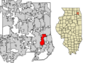
Location of Westmont in DuPage County, Illinois.
See also
 In Spanish: Westmont (Illinois) para niños
