Barrington, Illinois facts for kids
Quick facts for kids
Barrington, Illinois
|
|||
|---|---|---|---|
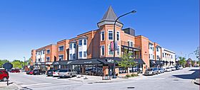
Downtown Barrington
|
|||
|
|||
| Motto(s):
"Be Inspired"
|
|||
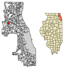
Location of Barrington in Cook and Lake counties, Illinois.
|
|||
| Country | United States | ||
| State | Illinois | ||
| County | Lake, Cook | ||
| Township | Barrington, Palatine, Cuba, Ela | ||
| Founded | 1865 | ||
| Government | |||
| • Type | Village | ||
| Area | |||
| • Total | 4.79 sq mi (12.41 km2) | ||
| • Land | 4.61 sq mi (11.93 km2) | ||
| • Water | 0.19 sq mi (0.48 km2) | ||
| Elevation | 830 ft (250 m) | ||
| Population
(2020)
|
|||
| • Total | 10,722 | ||
| • Density | 2,327.33/sq mi (898.50/km2) | ||
| Time zone | UTC-6 (CST) | ||
| • Summer (DST) | UTC-5 (CDT) | ||
| ZIP Codes |
60010, 60011
|
||
| Area codes | 847, 224 | ||
| FIPS code | 17-03844 | ||
| Wikimedia Commons | Barrington, Illinois | ||
Barrington is a village in Illinois, located in both Cook and Lake counties. It's a suburb northwest of Chicago. In 2020, about 10,722 people lived here. The area is known for its beautiful wetlands, forest preserves, parks, and horse riding trails. It offers a mix of country and suburban life. Barrington is part of the larger Chicago metropolitan area.
Contents
Discovering Barrington's Past
Early Days and Native Americans
The first people to live in the Barrington area were Native American tribes. These included the Prairie Potawatomi and Mascoutin tribes. Later, these groups split into the Potawatomi, Ojibwe, and Ottawa tribes. Many roads we use today, like Algonquin Road and Rand Road, were originally Native American trails. For a long time, Barrington was part of the Northwest Territory.
How Barrington Got Its Name
In 1833, after the Black Hawk War, Native American tribes gave up their land to the United States. This huge area was about 5 million acres (20,000 km²). Between 1833 and 1835, the U.S. government paid the tribes for this land.
Soon after, pioneers from Troy, New York, arrived in 1834. They settled in what is now Cuba Township. Other settlers from Vermont and New York also came to the area. Their settlement was first called Miller Grove. This was because many families named Miller lived there. It was later renamed Barrington Center. This name came from Great Barrington, Massachusetts. Many settlers came from that area.
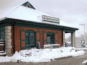
The Arrival of the Railroad
Barrington's growth is closely tied to the railroads from Chicago. In 1854, the Chicago and North Western Transportation Company (now the Union Pacific Northwest Line) extended its train line. They built a station called Deer Grove nearby.
A civil engineer named Robert Campbell bought land close to the station. He planned a new community there. Residents of Deer Grove wanted the station moved closer to their homes. So, the railroad moved the Deer Grove station to its current spot. Campbell named this new location Barrington. This was after Barrington Center. In 1855, the village's first lumber business opened.
Becoming an Official Village
By 1863, Barrington's population grew to 300 people. To help pay for improvements, the village asked to become officially incorporated. Because of delays from the Civil War, Barrington officially became a village on February 16, 1865. The first Village Board meeting was held on March 20, 1865. Homer Wilmarth was appointed as the first Mayor. In 1866, Milius B. McIntosh became the first elected Village President.
In 1889, another railroad, the Elgin, Joliet and Eastern Railway (EJ&E), was built through Barrington. It crossed the Union Pacific line.
Rebuilding After Fires
In the late 1800s, several fires damaged downtown buildings. In 1890, a fire destroyed buildings on East Main Street. In 1893, another fire hit Park Avenue. In 1898, more buildings on Main Street were destroyed. After these fires, people rebuilt using stronger brick and stone. Many of these buildings are still used today.
Barrington in the 20th Century
At the start of the 1900s, Barrington's streets were not paved. The downtown area had wooden sidewalks. There were also hitching posts for horses. Many homes in the village had livestock in their backyards.
In 1907, the village started replacing wooden sidewalks with cement. In 1929, the Jewel Tea Company built a new office and warehouse. This created many jobs during the Great Depression.
The last big fire in downtown Barrington was in 1989. It destroyed Lipofsky's Department Store. This was one of the oldest businesses in the village.
The Gunfight in Barrington
On November 27, 1934, a gunfight happened in Barrington. It was between FBI agents and a famous criminal, Baby Face Nelson. Two FBI agents, Herman "Ed" Hollis and Samuel P. Cowley, were killed. Nelson was shot but escaped. He later died from his injuries. A plaque in Langendorf Park remembers the agents who died.
Barrington Today: 21st Century
In 2009, residents voted to explore leaving Cook County. This was partly because of Cook County's high sales tax. Today, Barrington and nearby villages are known for being wealthy communities.
Train Traffic Concerns
Since 2008, Barrington has been in the news for its concerns about the Canadian National Railway (CN). CN bought the EJ&E line. This could mean many more freight trains passing through the village every day. The EJ&E crosses eight major roads in Barrington. This includes Northwest Highway and Lake Cook Road. More trains could cause traffic delays.
In 2008, then-U.S. Senator Barack Obama spoke out against the purchase. He promised to work with affected communities. In 2010, a 133-car CN train blocked several crossings for over an hour and a half. This caused major traffic jams. Later that year, Barrington received a $2.8 million grant. This money is for planning a way to separate the U.S. Route 14 road and the CN railroad tracks. This would allow traffic to flow without waiting for trains.
Where is Barrington?
Barrington is about 30 miles (48 km) northwest of Chicago. The village covers about 4.79 square miles (12.41 km²). Most of this area is land, with a small part being water.
Barrington's Weather
Barrington has a continental climate. This means it has warm summers and cold winters. Summers are usually wetter than winters. The highest temperature ever recorded was 103°F (39°C) in July 1974. The lowest was -28°F (-33°C) in January 2019.
Barrington has a slightly lower chance of tornadoes than the rest of Illinois. However, there have been some strong tornadoes nearby. In 1965, an F4 tornado about 9.4 miles (15 km) away killed 6 people. In 1967, another F4 tornado about 5.1 miles (8.2 km) away killed one person.
Who Lives in Barrington?
| Historical population | |||
|---|---|---|---|
| Census | Pop. | %± | |
| 1880 | 410 | — | |
| 1890 | 848 | 106.8% | |
| 1900 | 1,162 | 37.0% | |
| 1910 | 1,444 | 24.3% | |
| 1920 | 1,743 | 20.7% | |
| 1930 | 3,213 | 84.3% | |
| 1940 | 3,560 | 10.8% | |
| 1950 | 4,209 | 18.2% | |
| 1960 | 5,434 | 29.1% | |
| 1970 | 8,581 | 57.9% | |
| 1980 | 9,029 | 5.2% | |
| 1990 | 9,504 | 5.3% | |
| 2000 | 10,168 | 7.0% | |
| 2010 | 10,327 | 1.6% | |
| 2020 | 10,722 | 3.8% | |
| U.S. Decennial Census | |||
In 2020, Barrington had 10,722 people living there. There were 3,988 households. About 38.1% of households had children under 18. The average household size was 3.09 people. The median age in the village was 40.8 years old.
The median income for a household was $112,794. For families, it was $157,083. About 3.6% of the population lived below the poverty line.
Barrington's Economy
Barrington gets a lot of its sales tax money from its car dealerships. In 2008, sales from cars, gasoline, and auto repairs brought in about $2.1 million in sales taxes for the village. This was about 56% of its sales tax income.
The Gatorade Sports Science Institute used to be in Barrington. It was featured in many of the company's commercials. It closed in 2022. GE Healthcare IT was also once located here. Other important businesses include ISR Systems and GK Development. For many years, the Jewel Tea Company was based in Barrington. Its old headquarters was torn down to build Citizens Park.
Besides its downtown, Barrington has several shopping centers. These include the Ice House Mall and The Foundry.
Top Employers in Barrington
Here are some of the biggest employers in Barrington as of 2018:
| # | Employer | # of Employees |
|---|---|---|
| 1 | Barrington Community Unit School District #220 | 1,200 |
| 2 | Barrington Park District | 379 |
| 3 | Motor Werks of Barrington | 355 |
| 4 | The Garlands of Barrington | 295 |
| 5 | PepsiCo (Quaker Oats) | 287 |
| 6 | Barrington Transportation | 230 |
| 7 | Pepper Construction | 226 |
| 8 | Jewel Food Store | 190 |
| 9 | Wickstrom Ford | 176 |
| 10 | Heinen's | 142 |
Fun Things to Do in Barrington
Barrington has many annual events and celebrations. These include a Memorial Day parade and a Fourth of July parade with fireworks. There's also a Homecoming parade for Barrington High School.
The village also hosts the "Great Taste Fest of Barrington." This is a food festival where local restaurants show off their dishes. Every September, Advocate Good Shepherd Hospital hosts "Art in the Barn." This art show features art for sale. It started in 1974 with only 30 artists. Now, it attracts over 6,500 visitors. It also has live entertainment and pony rides for kids. This event has raised over $2.5 million for the hospital. In May, Barrington also has a "KidFest Kite Fly" event. It's a free family event that encourages outdoor fun.
Barrington also hosts many charity events. These include the Barrington CROP Hunger Walk. There's also Relay for Life by the American Cancer Society at Barrington High School. The Duck Race and Pool Party is a rubber duck race that helps JourneyCare.
The Barrington Area Library
The Barrington Area Library is a great place to visit. It has over 226,000 books and 27,000 audiovisual items. The library started in 1915. It moved to its current location in the mid-1970s. The building has been expanded and is now about 60,000 square feet (5,574 m²). The library often shows art by local artists. It even has an outdoor sculpture garden.
Unique Architecture in Barrington
The Village of Barrington has a Historic District. This area was created in 2001 to protect old buildings. Many buildings show Victorian, Victorian Gothic, and Queen Anne styles.
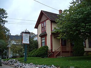
One special building is the Octagon House. It's also called the Hawley House. It was built around 1860. This house is listed on the National Register of Historic Places. It used to be a home, but now it's a business.
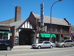
The downtown area is home to the historic Catlow Theater. It opened in May 1927. The Catlow is one of the few single-screen theaters left in the area. It's also listed on the National Register of Historic Places. The theater was one of the first to offer dining inside while watching a movie.
Another historic building is the Ice House Mall. It was built in 1904 for the Bowman Dairy. It was an actual ice house for 68 years. In the 1970s, it was renovated into a collection of specialty shops.
Part of the 2010 movie A Nightmare on Elm Street was filmed in Barrington. They used a home on Elm Street in the Jewel Park neighborhood as a backdrop.
Parks and Outdoor Fun
The Barrington area has many parks and nature preserves. The Arbor Day Foundation has named Barrington a Tree City USA every year since 1986. This is partly because of the village's rules for caring for trees.
The Barrington Park District manages several parks. These include Citizens Park, Langendorf Park, Miller Park, and Ron Beese Park. Langendorf Park has tennis courts, playgrounds, and basketball courts. It also has "Aqualusion," a water park with different pools and a splashpad.
Northeast of town is Cuba Marsh Forest Preserve. It's a 782-acre (3.16 km²) wetlands preserve. It has 3 miles (4.8 km) of trails. These trails offer great views of the marsh.
There are two golf courses in Barrington. Makray Memorial Golf Club is an 18-hole course. The Barrington Park District also runs a five-hole public course at Langendorf Park.
Learning in Barrington
Barrington is the center for the 72-square-mile (186 km²) Barrington Community Unit School District 220. Schools in Barrington include:
- Barrington High School
- Barrington Middle School - Prairie Campus
- Barrington Middle School - Station Campus
- Arnett C. Lines Elementary School
- Countryside Elementary School
- Grove Avenue Elementary School
- Hough Street Elementary School (a 2015 Blue Ribbon school)
- Roslyn Road Elementary School
St. Anne Catholic Community is a Catholic school for grades K-8.
News and Media
The Barrington Courier-Review is a local newspaper. Barrington also gets its TV and radio from the Chicago market. The Chicago Tribune and Chicago Sun-Times also cover local news. The village's Community Relations board broadcasts all Village Board meetings on a local government-access television (GATV) cable TV station.
Getting Around and Staying Safe
Transportation
Trains
Metra offers commuter train service on the Union Pacific Northwest Line. You can take the train from Barrington station southeast to Ogilvie Transportation Center in Chicago. You can also go northwest to Harvard or McHenry.
Main Roads
Medical and Emergency Services
In 1927, residents opened a "Barrington General Hospital." It closed in 1935. Later, people worked to bring a hospital back. Good Shepherd Hospital opened north of Barrington in 1979.
In 2009, the Barrington Police Department had 23 full-time police officers. In 2007, the Barrington Fire Department had 38 full-time firefighters. The Village has an emergency plan. It also uses a community notification system called Connect-CTY to send important alerts.
Famous People from Barrington
Images for kids
-
Gatorade Sports Science Institute formerly located on West Main Street
See also
 In Spanish: Barrington (Illinois) para niños
 | William L. Dawson |
 | W. E. B. Du Bois |
 | Harry Belafonte |


