Harvard, Illinois facts for kids
Quick facts for kids
Harvard, Illinois
|
|||
|---|---|---|---|
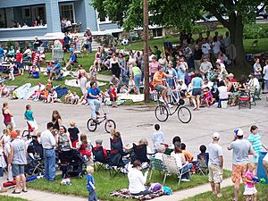
People gathered for the Harvard, Illinois Milk Days Parade. June 2, 2007
|
|||
|
|||
| Motto(s):
Success Comes Naturally Here
|
|||
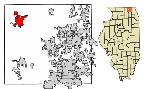
Location of Harvard in McHenry County, Illinois.
|
|||

Location of Illinois in the United States
|
|||
| Country | United States | ||
| State | Illinois | ||
| County | McHenry | ||
| Townships | Chemung, Dunham, Alden | ||
| Founded | February 28, 1867 | ||
| Area | |||
| • Total | 8.36 sq mi (21.64 km2) | ||
| • Land | 8.36 sq mi (21.64 km2) | ||
| • Water | 0.00 sq mi (0.00 km2) | ||
| Elevation | 922 ft (281 m) | ||
| Population
(2020)
|
|||
| • Total | 9,469 | ||
| • Density | 1,133.33/sq mi (437.58/km2) | ||
| Time zone | UTC-6 (CST) | ||
| • Summer (DST) | UTC-5 (CDT) | ||
| ZIP Code(s) |
60033
|
||
| Area codes | 815, 779 | ||
| FIPS code | 17-33331 | ||
| Commuter Rail | |||
| Website | cityofharvard.org | ||
Harvard is a city located in McHenry County, Illinois. It's home to 9,469 people, according to the 2020 census. The city is about 63 miles from downtown Chicago. It's also the very last stop on the Union Pacific Northwest Line train route.
Contents
History of Harvard
The land where Harvard now stands was first owned by Abram Carmack and Jacob Davis in 1845. They sold it to Gilbert Brainard. After Gilbert Brainard passed away, Amos Page, Otis Eastman, and Elbridge Gerry Ayer bought the land.
These three men planned the town and decided to name it "Harvard." They chose this name to honor Harvard, Massachusetts. The official town plan was signed on November 25, 1856.
Elbridge Gerry Ayer was very interested in extending the Chicago and North Western Transportation Company railroad. This railroad was being built west from Cary towards Janesville, Wisconsin. The new town of Harvard was right on the railroad's path. In April 1856, the railroad agreed to Ayer's offer of land to build a train station in Harvard.
The Ayer Hotel
In 1856, a hotel was built in Harvard. Mr. Elbridge Gerry Ayer bought it in 1859. He made the hotel taller, adding more floors and a porch. During the American Civil War, sick and injured soldiers traveling through Harvard could stay at the hotel for free.
Later, in 1925, the hotel was renamed the Noble Hotel. In 1937, it became the Hub Hotel. Sadly, the building was destroyed in a fire on December 22, 1960.
Becoming a City
As more people came to work for the railroad, Harvard's population grew. On April 18, 1869, the community officially became a village. Elbridge Gerry Ayer was elected as the first village president. One of the first rules was that every healthy citizen between 18 and 60 years old had to work one day for the town.
Harvard officially became a city on April 6, 1891. Citizens voted for this change, with 550 votes in favor and only 5 against. This meant Harvard would now be led by a mayor instead of a village president.
Motorola Plant
In 1997, Motorola opened a very large factory in Harvard. This factory made and shipped mobile phones. At its busiest, over 5,000 people worked there. However, Motorola's business slowed down in the early 2000s. Because of this, the company closed the factory in 2003. The large building was later sold to other companies.
Harvard's Celebrations
In 2006, Harvard celebrated its 150th birthday with a year-long party! The Greater Harvard Area Historical Society helps find and mark important historical places in the area. They also collect stories about Harvard families, businesses, and farms that have been around for over 100 years.
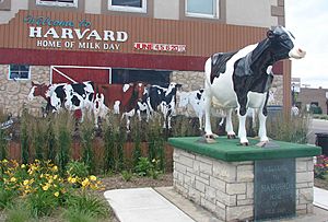
Harvard is known as the "Milk Capital of the World." Every year, they host the Harvard Milk Days festival on the first weekend of June. This festival celebrates Harvard's important role in milk production during World War II. A special symbol of the festival is Harmilda the cow. This statue is 5 feet tall, 8 feet long, and weighs about 125 pounds!
Geography
Harvard covers an area of about 8.58 square miles (22.2 square kilometers). All of this area is land.
Main Streets in Harvard
Here are some of the important roads in Harvard:
- Airport Road
- Ayer Street
- Crowley Road
 Diggins Street/Brink Street
 Division Street
- Flat Iron Road
- Lawrence Road
 Marengo Street
- McGuire Road
- Oak Grove Road
- Ramer Road
Population Changes
| Historical population | |||
|---|---|---|---|
| Census | Pop. | %± | |
| 1870 | 1,120 | — | |
| 1880 | 1,607 | 43.5% | |
| 1890 | 1,967 | 22.4% | |
| 1900 | 2,602 | 32.3% | |
| 1910 | 3,008 | 15.6% | |
| 1920 | 3,294 | 9.5% | |
| 1930 | 2,988 | −9.3% | |
| 1940 | 3,121 | 4.5% | |
| 1950 | 3,464 | 11.0% | |
| 1960 | 4,248 | 22.6% | |
| 1970 | 5,177 | 21.9% | |
| 1980 | 5,126 | −1.0% | |
| 1990 | 5,975 | 16.6% | |
| 2000 | 7,996 | 33.8% | |
| 2010 | 9,447 | 18.1% | |
| 2020 | 9,469 | 0.2% | |
| U.S. Decennial Census 2010 2020 |
|||
Harvard's population has grown a lot over the years. In 1870, there were 1,120 people living here. By 2020, the population had reached 9,469. This shows how the city has expanded and welcomed more residents over time.
Education in Harvard
The Harvard School District No. 50 runs five schools in the city:
- Harvard High School: for students in grades 9-12.
- Harvard Junior High School: for students in grades 6-8.
- Jefferson Elementary School: for students in grades 4 and 5.
- Richard B. Crosby Elementary School: for students in grades K-3.
- Washington School: for Pre-Kindergarten (Pre-K) and Early Childhood Education (ECE) students.
There was also a Catholic school, St. Joseph's School, which taught students from pre-kindergarten to 8th grade. However, this school closed at the end of the 2015-2016 school year due to financial reasons.
Harvard Diggins Library
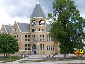
The Harvard Diggins Library first opened its doors to the community in 1909. A man named Delos F. Diggins, who grew up in Harvard, left money to the city to build a library. This building, called the Delos F. Diggins Library, was the first public library in McHenry County that stood on its own.
The library served the community in that building until a new one was built in 2001. To honor Delos Diggins's lasting gift, the library was renamed the Harvard Diggins Library. Today, it's part of a group of libraries that share resources, making it easier for people to borrow books from many places in Illinois.
The Harvard Diggins Library building is very large, with 19,000 square feet of space. It has special areas for kids, teens, and quiet study. There are also rooms for meetings. The library often hosts public events like talks, performances, craft activities, and story times. If you live in Harvard, you can get a free library card. This card lets you borrow materials from most public libraries in Illinois.
Post Office
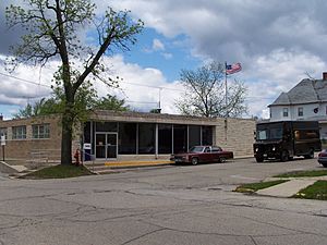
Harvard's U.S. Post Office is located on North Eastman Street. The building you see today was built in 1962.
Law Enforcement
The Harvard Police Department is located in the old City Hall building. It has 17 full-time police officers, led by Chief of Police Tyson Bauman. They also have a record clerk and a community services officer.
The police department works with the North East Regional Communications Center (NERCOM) for dispatch services. This center is in McHenry, Illinois. The department also has a full-time detective and a school resource officer. Officers use bicycles to patrol the city streets, parks, and downtown area.
Fire Protection
The Harvard Fire Protection District has 47 trained firefighters. Many of them are also Emergency Medical Technicians (EMTs) or paramedics. The district's history goes back to 1865, when five men bought a fire engine for the village.
In 1871, that fire engine was sent by train to Chicago to help fight the Great Chicago Fire. In 1892, it was put on a train again to help with a fire in Kenosha, Wisconsin. The Harvard Fire Department officially formed in 1899.
The Harvard Rescue Squad started in 1956 with a donation of $7,000. In 1971, the city and rural fire departments joined together to form the Harvard Fire Protection District.
Today, the Fire Protection District is managed by a board of five trustees. Even though they work closely with the city of Harvard, they are a separate government agency. The district provides fire and emergency medical services for about 108 square miles (280 square kilometers). They get money from ambulance fees and property taxes. The district also has a SCUBA dive team trained for water rescues.
Transportation
You can find several important roads in Harvard. U.S. Route 14, also known as Northwest Highway and Division Street, runs through Harvard from north to south. Illinois Route 23 starts in southern Harvard and connects the city to places further south. Illinois Route 173 runs east to west and links Harvard to many other towns near the Wisconsin border. The closest major highways are Interstate 90 in Belvidere, Interstate 39 in Machesney Park, and Interstate 43 in Wisconsin.
Harvard also has public transportation options. Pace operates Route 808, which connects Harvard to nearby communities like Woodstock and Crystal Lake. Metra's Union Pacific Northwest Line has a train station in Harvard. This train offers daily service to Chicago's Ogilvie Transportation Center. Harvard station is the farthest point on the Metra system, about 63.16 miles (101.65 kilometers) from downtown Chicago.
Media
Harvard has its own community radio station, WHIW-LP 101.3 FM. It started broadcasting on FM in May 2015, but before that, you could hear it on AM 1610. WHIW-LP also streams its programs online.
WHIW-LP offers local programs, including news, sports, school updates, music, and arts. It's run entirely by volunteers and relies on support from its listeners.
Harvard used to have a daily newspaper called the Harvard Herald, which was published from 1887 to 1986. In September 2009, a new monthly publication called the Harvard Main Line was launched. The city is also covered by the Northwest Herald, which reports on all of McHenry County.
Famous People from Harvard
- Edward E. Ayer (1841–1927): He helped start important museums and libraries in Chicago.
- Elbridge Ayer Burbank (1858–1949): A painter famous for his portraits of Native Americans, especially Geronimo.
- Bobby Cook (1923–2004): A professional basketball player.
- Clarence Darrow (1857–1938): A famous lawyer who had an office in Harvard.
- Dorothy Ayer Gardner Ford: The mother of President Gerald Ford.
- Paul Galvin (1895–1959): The person who founded the Motorola company.
- Lon Haldeman: A cyclist who won the Race Across America.
- Red Lanning: A baseball player who pitched and played outfield for the Philadelphia Athletics.
- Carol Richards (1922–2007): A singer and personality on radio and TV.
- Jonathan J. Smith: A state lawmaker in Wisconsin.
Images for kids
See also
 In Spanish: Harvard (Illinois) para niños
 | Chris Smalls |
 | Fred Hampton |
 | Ralph Abernathy |


