Lyons, Illinois facts for kids
Quick facts for kids
Lyons, Illinois
|
||
|---|---|---|

|
||
|
||
| Motto(s):
Gateway to the West
|
||

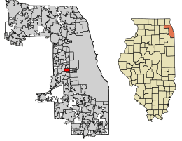
Location of Lyons in Cook County, Illinois.
|
||
| Country | United States | |
| State | Illinois | |
| County | Cook | |
| Incorporated | 1888 | |
| Area | ||
| • Total | 2.27 sq mi (5.89 km2) | |
| • Land | 2.21 sq mi (5.72 km2) | |
| • Water | 0.07 sq mi (0.17 km2) | |
| Elevation | 620 ft (190 m) | |
| Population
(2020)
|
||
| • Total | 10,817 | |
| • Density | 4,901.22/sq mi (1,891.99/km2) | |
| Time zone | UTC-6 (CST) | |
| • Summer (DST) | UTC-5 (CDT) | |
| ZIP Code(s) |
60534
|
|
| Area code(s) | 708 | |
| FIPS code | 17-45434 | |
Lyons is a village in Cook County, Illinois, United States. It's a community with a population of about 10,817 people, according to the 2020 census. A special place called the Chicago Portage National Historic Site is found right here in Lyons.
Contents
History of Lyons
Lyons was first settled in 1888. However, its history goes back much further! In 1673, a French explorer named Louis Jolliet and a Jesuit missionary, Father Pierre Marquette, traveled by canoe from Green Bay, Wisconsin. They were looking for a way to the Pacific Ocean.
As they explored, they realized the big Mississippi River flowed into the Gulf of Mexico. Winter was coming, so they needed to head north quickly. Potawatomi people with them suggested a shortcut using the Illinois River. This led them to the Des Plaines River.
Here, they found "Le Portage." This was a half-mile wide area of land. It connected the Chicago River and the Des Plaines River. They could carry their canoes and supplies across this land. This discovery became very famous!
Later, this area was known as the Chicago Portage. It became known as the "Gateway to the West." Thousands of early settlers and traders used it to travel east and west. Finding "Le Portage" helped Chicago become a major center for world trade.
Louis Jolliet had an idea to build a canal connecting these two waterways. This idea came true 200 years later with the Illinois and Michigan Canal. Over time, parts of this canal were replaced by the Chicago Sanitary and Ship Canal, finished in 1900.
Today, you can see a statue in Lyons at the Chicago Portage National Historic Site. It's just north of Interstate 55 along Harlem Avenue. This statue remembers the important history of this area.
In the past, Lyons faced some challenges related to crime. However, the village has changed a lot since the 1990s. Many of the old clubs and bars are gone now.
Lyons is a working-class area. Many people from Poland settled here in the early 1900s. You can see this history in some street names like Pulaski, Warsaw, and Cracow. These names honor Polish heritage.
Geography of Lyons
Lyons is located at 41°48′48″N 87°49′19″W / 41.81333°N 87.82194°W. The village covers about 2.24 square miles (5.72 square kilometers). Most of this area is land, with a small part being water.
People of Lyons (Demographics)
| Historical population | |||
|---|---|---|---|
| Census | Pop. | %± | |
| 1880 | 486 | — | |
| 1890 | 732 | 50.6% | |
| 1900 | 951 | 29.9% | |
| 1910 | 1,483 | 55.9% | |
| 1920 | 2,564 | 72.9% | |
| 1930 | 4,787 | 86.7% | |
| 1940 | 4,960 | 3.6% | |
| 1950 | 6,120 | 23.4% | |
| 1960 | 9,936 | 62.4% | |
| 1970 | 11,124 | 12.0% | |
| 1980 | 9,925 | −10.8% | |
| 1990 | 9,828 | −1.0% | |
| 2000 | 10,255 | 4.3% | |
| 2010 | 10,729 | 4.6% | |
| 2020 | 10,817 | 0.8% | |
| U.S. Decennial Census 2010 2020 |
|||
As of the 2020 census, Lyons had 10,817 people living there. There were 3,651 households, which are groups of people living together.
About 24.7% of the people were under 18 years old. About 15.7% were 65 years or older. The average age in the village was 36.4 years.
The median income for a household was $66,005. This means half of the households earned more than this, and half earned less. For families, the median income was $76,892.
Transportation in Lyons
Pace provides bus services in Lyons. These buses connect the village to other places in the region.
Education in Lyons
Lyons is part of the Lyons Elementary School District 103. This district runs five elementary schools. Two of these schools, Costello and Robinson Elementary Schools, are in Lyons.
Other elementary schools in the district are Home and Edison in Stickney, and Lincoln in Brookfield. After elementary school, students attend George Washington Middle School.
High school students from Lyons go to J. Sterling Morton High School West. This high school is located in Berwyn.
Lyons also has its own public library. It is called the Lyons Public Library and is located at 4209 Joliet Avenue.
See also
 In Spanish: Lyons (Illinois) para niños
 | Janet Taylor Pickett |
 | Synthia Saint James |
 | Howardena Pindell |
 | Faith Ringgold |


