Stickney, Illinois facts for kids
Quick facts for kids
Stickney, Illinois
|
||
|---|---|---|
|
||
| Motto(s):
A Community That Cares
|
||

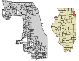
Location of Stickney in Cook County, Illinois.
|
||
| Country | ||
| State | Illinois | |
| County | Cook | |
| Township | Stickney | |
| Incorporated | 1913 | |
| Government | ||
| • Type | Trustee-village | |
| Area | ||
| • Total | 1.96 sq mi (5.08 km2) | |
| • Land | 1.92 sq mi (4.98 km2) | |
| • Water | 0.04 sq mi (0.09 km2) 2.04% | |
| Population
(2020)
|
||
| • Total | 7,110 | |
| • Density | 3,695.43/sq mi (1,426.59/km2) | |
| Up 10.38% from 2000 | ||
| Standard of living (2007-11) | ||
| • Per capita income | ,972 | |
| • Median home value | 4,000 | |
| ZIP code(s) |
60402
|
|
| Area code(s) | 708 | |
| Geocode | 72676 | |
| FIPS code | 17-72676 | |
Stickney is a village located in Cook County, Illinois, United States. In 2020, about 7,110 people lived there. The village got its name from Alpheus Beede Stickney. He was a railroad executive who helped create the Clearing Industrial District nearby.
Contents
Where is Stickney Located?
Stickney is found at coordinates 41°49′1″N 87°47′12″W / 41.81694°N 87.78667°W. It covers a total area of about 1.96 square miles (5.08 square kilometers). Most of this area, about 1.93 square miles (4.98 square kilometers), is land. A small part, about 0.036 square miles (0.09 square kilometers), is water.
Who Lives in Stickney?
| Historical population | |||
|---|---|---|---|
| Census | Pop. | %± | |
| 1920 | 550 | — | |
| 1930 | 2,005 | 264.5% | |
| 1940 | 2,446 | 22.0% | |
| 1950 | 3,317 | 35.6% | |
| 1960 | 6,239 | 88.1% | |
| 1970 | 6,601 | 5.8% | |
| 1980 | 5,893 | −10.7% | |
| 1990 | 5,678 | −3.6% | |
| 2000 | 6,148 | 8.3% | |
| 2010 | 6,786 | 10.4% | |
| 2020 | 7,110 | 4.8% | |
| U.S. Decennial Census 2010 2020 |
|||
As of the 2020 census, there were 7,110 people living in Stickney. There were 2,314 households and 1,617 families. The village had about 3,627 people per square mile.
Many different groups of people live in Stickney. About 64.25% of the population identified as Hispanic or Latino. Other groups included White (39.68%), African American (2.64%), Native American (3.33%), and Asian (1.42%). Some people also identified with two or more races.
About 37% of households had children under 18 living with them. The average household had about 3.52 people. The average family had about 2.83 people.
The median age in the village was 39.0 years. This means half the people were younger than 39, and half were older. About 26.3% of the population was under 18 years old.
The median income for a household in Stickney was $67,246. For families, the median income was $87,997. The per capita income for the village was $27,977.
Schools in Stickney
Stickney has public elementary schools for younger students. These schools are Home School and Edison School. They are part of Lyons Elementary School District 103 and teach grades K-5. After elementary school, students go to George Washington Middle School in Lyons for grades 6–8.
For high school, students attend Morton West High School. This high school is located in Berwyn. All students living in Stickney go to Morton West High School.
In the past, Stickney had other schools that are no longer open. Haley School was built in 1923 and was later taken down in 1987. The land where it stood became Haley Park in 1989. MacArthur School also closed and was demolished. St Pius X Church also had an elementary school that closed in the 1990s.
Getting Around Stickney
Bus services help people travel around the village. These services are provided by the CTA and Pace.
See also
 In Spanish: Stickney (Illinois) para niños
 | Lonnie Johnson |
 | Granville Woods |
 | Lewis Howard Latimer |
 | James West |


