Dolton, Illinois facts for kids
Quick facts for kids
Dolton, Illinois
|
|||
|---|---|---|---|

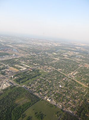
Aerial view of Dolton in 2012
|
|||
|
|||
| Motto(s):
"A community working together"
|
|||

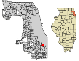
Location of Dolton in Cook County, Illinois.
|
|||
| Country | United States | ||
| State | Illinois | ||
| County | Cook | ||
| Township | Thornton | ||
| Incorporated | 1893 | ||
| Government | |||
| • Type | Mayor-council | ||
| Area | |||
| • Total | 4.69 sq mi (12.14 km2) | ||
| • Land | 4.57 sq mi (11.84 km2) | ||
| • Water | 0.12 sq mi (0.30 km2) 2.56% | ||
| Population
(2020)
|
|||
| • Total | 21,426 | ||
| • Density | 4,687.38/sq mi (1,809.94/km2) | ||
| Standard of living (2009-11) | |||
| • Per capita income | $21,742 | ||
| • Median home value | $131,600 | ||
| Time zone | Central Standard Time | ||
| ZIP code(s) |
60419
|
||
| Area code(s) | 708 | ||
| Geocode | 17-20292 | ||
| FIPS code | 17-20292 | ||
Dolton (pronounced like "DAWL-ton") is a village in Cook County, Illinois, United States. It's located just west of Interstate 94 and right next to the city of Chicago. In 2020, about 21,426 people lived there. The main ZIP code for Dolton is 60419.
Dolton shares its borders with several other places. To the north is Chicago. To the west, you'll find Riverdale and Harvey. South Holland is to the south, and Calumet City is to the east.
Contents
History of Dolton
When Was Dolton Founded?
Dolton has had a post office since 1854. This means people were living and sending mail there a long time ago. The village got its name from one of the first families who settled in the area.
How Dolton Became a Village
For a while, Dolton and a nearby place called Riverdale were like one big community. But in 1892, they officially became separate villages. Dolton was then formally established as an incorporated village in 1893.
Geography of Dolton
What is Dolton's Size?
In 2021, Dolton covered an area of about 4.69 square miles (12.14 square kilometers). Most of this area, about 97.50%, is land. The remaining 2.50% is water.
Education in Dolton
Schools and Colleges in Dolton
The entire village of Dolton is part of the South Suburban Community College District 510. This district helps provide education for students in the area.
People of Dolton
How Many People Live in Dolton?
The population of Dolton has changed over the years. Here's how it has grown and shifted:
| Historical population | |||
|---|---|---|---|
| Census | Pop. | %± | |
| 1880 | 448 | — | |
| 1890 | 1,110 | 147.8% | |
| 1900 | 1,229 | 10.7% | |
| 1910 | 1,869 | 52.1% | |
| 1920 | 2,076 | 11.1% | |
| 1930 | 2,923 | 40.8% | |
| 1940 | 3,058 | 4.6% | |
| 1950 | 5,338 | 74.6% | |
| 1960 | 18,746 | 251.2% | |
| 1970 | 25,937 | 38.4% | |
| 1980 | 24,766 | −4.5% | |
| 1990 | 23,956 | −3.3% | |
| 2000 | 25,614 | 6.9% | |
| 2010 | 23,153 | −9.6% | |
| 2020 | 21,426 | −7.5% | |
| U.S. Decennial Census 2010 2020 |
|||
Who Lives in Dolton?
In the 2020 census, there were 21,426 people living in Dolton. There were 7,985 households, which are groups of people living together in one home. About 5,361 of these were families.
The census also looks at the different backgrounds of people. In 2020, about 90.69% of the people in Dolton were African American. About 3.25% were White, and 4.37% were Hispanic or Latino. People from other backgrounds also live in Dolton, making it a diverse community.
Households and Families
About 29.0% of the households in Dolton had children under 18 living with them. Around 25.45% of households were married couples. In 35.94% of households, a female was the head of the house without a husband present.
The average household in Dolton had about 3.44 people. The average family had about 2.78 people.
Age Groups in Dolton
The people in Dolton are of all ages. About 24.8% of the population was under 18 years old. Around 15.7% were 65 years old or older. The median age, which is the middle age of all the people, was 36.7 years.
Income in Dolton
In Dolton, the median income for a household was $50,237. For families, the median income was $57,634. The per capita income, which is the average income per person, was $22,135.
Transportation in Dolton
Getting Around Dolton
Pace provides bus services in Dolton. These buses connect the village to many other places in the Southland area. There are also plans for a new train service called Metra’s SouthEast Service to have a station in Dolton. This would make it easier for people to travel by train, something that hasn't been available since 1935.
Famous People from Dolton
Many interesting people have connections to Dolton.
- William Shaw was an important figure. He was an Illinois state legislator and became the first African-American mayor of Dolton.
- After William Shaw, Ronnie Lewis became mayor. He was the first African-American to hold an official position in the Dolton government.
- Nelsan Ellis, an actor known for his role as Lafayette Reynolds in the TV show True Blood, grew up in Dolton.
- Film critic Richard Roeper, who writes about movies, also grew up in Dolton.
Images for kids
See also
 In Spanish: Dolton (Illinois) para niños
 | Percy Lavon Julian |
 | Katherine Johnson |
 | George Washington Carver |
 | Annie Easley |


