
Arlington Heights, Illinois facts for kids
Quick facts for kids
Arlington Heights, Illinois
|
|||
|---|---|---|---|

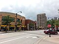
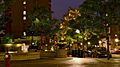
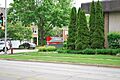
Evergreen Avenue in Downtown Arlington Heights
|
|||
|
|||
| Nickname(s):
Action Heights
|
|||
| Motto(s):
Village of Good Neighbors
|
|||

Location of Arlington Heights in Cook County, Illinois.
|
|||

Arlington Heights, Illinois
Location in Greater Chicago

Arlington Heights, Illinois
Location in Illinois

Arlington Heights, Illinois
Location in the United States
|
|||
| Country | United States | ||
| State | Illinois | ||
| Counties | Cook, Lake | ||
| Townships | Wheeling, Elk Grove, Palatine, Vernon | ||
| Incorporated | 1887 | ||
| Government | |||
| • Type | Council–manager | ||
| Area | |||
| • Total | 16.64 sq mi (43.09 km2) | ||
| • Land | 16.61 sq mi (43.01 km2) | ||
| • Water | 0.03 sq mi (0.08 km2) | ||
| Elevation | 702 ft (214 m) | ||
| Population
(2020)
|
|||
| • Total | 77,676 | ||
| • Density | 4,677.87/sq mi (1,806.10/km2) | ||
| Standard of living | |||
| Time zone | Central | ||
| ZIP Codes |
60004, 60005, and 60006 (PO boxes)
|
||
| Area code(s) | 847 and 224 | ||
| Geocode | 02154 | ||
| FIPS code | 17-02154 | ||

.jpg)
Arlington Heights is a village in Cook County, Illinois, United States. It's a suburb of Chicago, located about 25 miles (40 km) northwest of the city's downtown. In 2020, the village had a population of 77,676 people. This makes it the 15th most populated town in Illinois.
Arlington Heights is famous for the former Arlington Park Race Track. This track hosted big horse racing events like the Arlington Million. In 2002, it even held the Breeders' Cup World Thoroughbred Championships. The village is also home to the Arlington Heights Memorial Library. It has one of the largest collections of books in the state.
Contents
History
Arlington Heights is mostly located in Wheeling Township. It also includes parts of Elk Grove and Palatine townships. This area was once known for having very few trees.
Early History of the Land
The land where Arlington Heights is now was first controlled by the Miami Confederacy. This group included the Illini and Kickapoo tribes. This was in the early 1680s. Later, in the 1700s, the Iroquois and Meskwaki tribes took over the area.
Then, the Potawatomi tribe, who were allies with the French, started to take control of Northern Illinois. By the early 1800s, they controlled a large area. This stretched from Green Bay to the Illinois River, and from the Mississippi River to the Maumee River.
During the 1830s, the Potawatomi used to set up a camp in what is now Arlington Heights. They stayed there for about six weeks each year. This was part of their journey between their summer and winter homes.
In 1833, the Potawatomi signed a deal with the United States Government. This was called the 1833 Treaty of Chicago. Through this treaty, the U.S. gained control of the land that is now Arlington Heights. This led to many white settlers moving into the area. The U.S. Government bought the land for about 15 cents per acre. They then sold it to settlers for $1.25 per acre.
The Potawatomi sometimes returned to visit their ancestors' burial sites. However, these visits stopped as settlers built farms and destroyed the old villages. Today, the descendants of the Potawatomi who lived here now live on a reservation in Kansas.
From West Wheeling to Dunton
Many important roads in the Arlington Heights area were built on old Native American trails. For example, Rand Road was built on a trail that passed by Socrates Rand's property. Arlington Heights Road came from a trail that went from what is now Naperville to Half Day.
Around this time, a trading post was set up by Frederick T. Miner. The cabins near his post became known as West Wheeling.
In 1837, a settler named Asa Dunton claimed land in the western part of Wheeling Township. In 1845, his son, William Dunton, moved to a house he built by a Potawatomi trail. This trail became known as Dunton's Road, which is now Arlington Heights Road. Because of William Dunton, West Wheeling became known as Dunton. The town's name changed a few times before it officially became Arlington Heights in 1874.
William Dunton convinced the Illinois & Wisconsin Railroad company to build tracks through his land. In 1853, he sold 16 acres to the company for $350. The first train station in Dunton was built in 1854. The railroad helped the town grow, as it made it easier for new settlers to arrive.
_02.JPG)
By 1850, many German farmers from Saxony had moved to the area. They grew potatoes and other vegetables for the Chicago market. John Klehm, for example, started a nursery in 1856, growing fruit trees and later other trees and flowers. By the late 1850s, the area was known for its farms. They sent dairy products and vegetables to Chicago by train.
During the Civil War, Chicago's population grew quickly. Many people moved to nearby villages like Dunton. Dunton also saw more German immigrants. By the 1870s, Dunton's population was over 1,200.
Arlington Heights During the Civil War
Several Dunton residents fought in the Civil War. Only three of them returned home. One survivor, Charles Sigwalt, fought in battles like Chickamauga. Sigwalt Street is named after him.
Warren Kennicott, for whom Kennicott Avenue is named, was killed at the Battle of Gettysburg.
During the Civil War, Arlington Heights was a stop for many Union soldiers. They traveled south to fight the Confederacy or north for the Dakota War.
Becoming Arlington Heights
Dunton continued to grow after the Civil War. It gained new businesses like a blacksmith, a cheese factory, and a hotel. In 1874, the town's name officially changed to Arlington Heights.
In 1878, Civil War veteran Charles Sigwalt and his brother John started the Sigwalt Sewing Machine Company. They made 40,000 machines before a fire destroyed the company in 1895. Arlington Heights became an early "commuter suburb," meaning people lived there and traveled to work in the city.
Religious History
The town developed churches that reflected where its citizens came from. The first churches were Presbyterian (1856) and Methodist (1858). St. Peter Lutheran Church, a German Lutheran church, followed in 1860. Today, the village has many churches of different faiths. This includes large Roman Catholic and Lutheran churches, as well as other Protestant churches.
Arlington Park Racetrack

By the early 1900s, Arlington Heights had about 1,400 people. It grew slowly, with many farms and greenhouses, even after World War II. Arlington Heights became known for Arlington Park, a racetrack built in 1927. It was founded by Harry D. "Curly" Brown on land that used to be 12 farms.
On July 31, 1985, a fire destroyed the grandstand. A new, six-story grandstand was built and opened on June 28, 1989.
In 2021, the track's owners announced they would sell the site. The Chicago Bears football team became interested in buying Arlington Park. They considered building a new stadium there, possibly leaving their current home at Soldier Field in Chicago. On September 29, 2021, the Bears and Churchill Downs agreed on a $197.2 million deal for the property.
Population Growth
Arlington Heights saw a huge population increase in the 1950s and 1960s. More people owned cars, the Chicago economy grew, and many families moved from the city. The village expanded by adding nearby areas. By 1970, the population reached 64,884. Almost all the available land was built on. The once quiet train stop became part of a continuous developed area.
Geography

.jpg)
Arlington Heights is located at 42.094976 degrees North latitude and -87.980873 degrees West longitude.
In 2021, Arlington Heights had a total area of about 16.64 square miles (43.09 square kilometers). Most of this, about 16.61 square miles (43.01 square kilometers), is land. Only a small part, about 0.03 square miles (0.08 square kilometers), is water.
Climate
| Climate data for Arlington Heights, Illinois | |||||||||||||
|---|---|---|---|---|---|---|---|---|---|---|---|---|---|
| Month | Jan | Feb | Mar | Apr | May | Jun | Jul | Aug | Sep | Oct | Nov | Dec | Year |
| Record high °F (°C) | 62 (17) |
69 (21) |
83 (28) |
89 (32) |
93 (34) |
102 (39) |
103 (39) |
100 (38) |
96 (36) |
88 (31) |
75 (24) |
66 (19) |
103 (39) |
| Mean daily maximum °F (°C) | 28 (−2) |
33 (1) |
44 (7) |
57 (14) |
68 (20) |
78 (26) |
82 (28) |
79 (26) |
72 (22) |
60 (16) |
47 (8) |
33 (1) |
57 (14) |
| Daily mean °F (°C) | 21 (−6) |
25 (−4) |
35 (2) |
48 (9) |
58 (14) |
68 (20) |
73 (23) |
70 (21) |
62 (17) |
51 (11) |
39 (4) |
26 (−3) |
48 (9) |
| Mean daily minimum °F (°C) | 13 (−11) |
17 (−8) |
26 (−3) |
38 (3) |
48 (9) |
58 (14) |
63 (17) |
61 (16) |
52 (11) |
41 (5) |
30 (−1) |
18 (−8) |
39 (4) |
| Record low °F (°C) | −26 (−32) |
−21 (−29) |
−9 (−23) |
5 (−15) |
22 (−6) |
35 (2) |
38 (3) |
38 (3) |
25 (−4) |
14 (−10) |
−10 (−23) |
−20 (−29) |
−26 (−32) |
| Average precipitation inches (mm) | 1.90 (48) |
1.97 (50) |
2.29 (58) |
3.56 (90) |
4.24 (108) |
3.85 (98) |
3.78 (96) |
4.86 (123) |
3.40 (86) |
3.10 (79) |
3.04 (77) |
2.26 (57) |
38.25 (970) |
| Source: weather.com | |||||||||||||
Demographics
| Historical population | |||
|---|---|---|---|
| Census | Pop. | %± | |
| 1890 | 1,424 | — | |
| 1900 | 1,380 | −3.1% | |
| 1910 | 1,943 | 40.8% | |
| 1920 | 2,250 | 15.8% | |
| 1930 | 4,997 | 122.1% | |
| 1940 | 5,668 | 13.4% | |
| 1950 | 8,768 | 54.7% | |
| 1960 | 27,878 | 218.0% | |
| 1970 | 65,058 | 133.4% | |
| 1980 | 66,116 | 1.6% | |
| 1990 | 75,460 | 14.1% | |
| 2000 | 76,031 | 0.8% | |
| 2010 | 75,101 | −1.2% | |
| 2020 | 77,676 | 3.4% | |
| U.S. Decennial Census 2010 2020 |
|||
As of the 2020 census, Arlington Heights had 77,676 people living in 30,672 households. About 19,988 of these were families. The population density was about 4,669 people per square mile. There were 33,356 housing units.
The people living in the village were mostly White (78.95%). There were also significant numbers of Asian (10.77%) and African American (1.63%) residents. About 6.94% of the population identified as Hispanic or Latino.
In terms of age, 22.9% of the population was under 18 years old. About 19.6% were 65 years or older. The average age in the village was 43.4 years.
The average income for a household in the village was $100,221. For families, it was $126,753. About 4.2% of the total population lived below the poverty line.
| Race / Ethnicity (NH = Non-Hispanic) | Pop 2000 | Pop 2010 | Pop 2020 | % 2000 | % 2010 | % 2020 |
|---|---|---|---|---|---|---|
| White alone (NH) | 66,612 | 63,532 | 60,333 | 87.61% | 84.60% | 77.67% |
| Black or African American alone (NH) | 706 | 936 | 1,195 | 0.93% | 1.25% | 1.54% |
| Native American or Alaska Native alone (NH) | 35 | 48 | 56 | 0.05% | 0.06% | 0.07% |
| Asian alone (NH) | 4,534 | 5,320 | 8,323 | 5.96% | 7.08% | 10.72% |
| Pacific Islander alone (NH) | 22 | 7 | 14 | 0.03% | 0.01% | 0.02% |
| Other race alone (NH) | 68 | 72 | 207 | 0.09% | 0.10% | 0.27% |
| Mixed race or Multiracial (NH) | 661 | 880 | 2,160 | 0.87% | 1.17% | 2.78% |
| Hispanic or Latino (any race) | 3,393 | 4,306 | 5,388 | 4.46% | 5.73% | 6.94% |
| Total | 76,031 | 75,101 | 77,676 | 100.00% | 100.00% | 100.00% |
Economy
Arlington Heights has seen a lot of new development recently. This includes new condos, restaurants, and other businesses in the downtown area. Restaurants have been especially successful. Even though there isn't much empty land left, the village focuses on developing businesses and the community. Arlington Heights is also home to many good hotels.
Top Employers
Here are some of the biggest employers in Arlington Heights, based on a 2017 report:
| # | Employer | # of Employees |
|---|---|---|
| 1 | Arlington International Racecourse (seasonal) | 4,500 |
| 2 | Northwest Community Healthcare | 3,600 |
| 3 | Arlington Heights High School District #214 | 1,700 |
| 4 | Clearbrook | 1,500 |
| 5 | Lutheran Home | 800 |
| 6 | Paddock Publications | 500 |
| 7 | Alexian Brothers Health System | 500 |
| 8 | Clearbrook | 450 |
| 9 | Kroeschell Inc. | 450 |
| 10 | Village of Arlington Heights | 450 |
Arts and Culture
Entertainment Venues
From 1964 to 1970, Arlington Heights was home to The Cellar. This club was in an old warehouse and offered live rock and blues bands. It was a popular spot for teenagers. Many regional bands played there, as well as famous groups like The Who, The Byrds, and Cream.
Today, entertainment venues include the Metropolis Performing Arts Centre. It opened in 1999 in downtown Arlington Heights. The Metropolis offers live shows and arts classes. It has a 350-seat theater, a ballroom, and classrooms for music and theater. Another music venue, Hey Nonny, opened in 2018.
Notable Landmarks


- Lake Arlington
- Mitsuwa Marketplace - Chicago
Parks and Recreation
Education
Schools in Arlington Heights
.jpg)
Public elementary and middle schools in Arlington Heights are mostly run by Arlington Heights School District 25. Some parts of the city are also served by other school districts. There are 17 elementary schools and nine middle schools that serve different areas of Arlington Heights.
Public high schools are managed by Township High School District 214. There is one public high school in the city itself, John Hersey High School. Other high schools in District 214 that serve parts of Arlington Heights include Buffalo Grove, Prospect, Rolling Meadows, and Wheeling. Some students also attend Palatine High School in District 211.
In the past, from the 1960s to the 1980s, Arlington Heights had three public high schools. These were Hersey, Arlington High School, and Forest View High School. Arlington High School, founded in 1922, closed in 1984 and is now a private school called Christian Liberty Academy. Forest View High School closed in 1986 and is now the district's administration center.
There are also several private schools in Arlington Heights. These include St. Viator High School, Our Lady of Wayside School, St. James School, St. Peter Lutheran School, and Christian Liberty Academy. The Chicago Futabakai Japanese School, which offers classes for Japanese students, is also located here.
Media
- The Daily Herald: This is the main local newspaper for Arlington Heights and many other Chicago suburbs.
- Journal & Topics: This newspaper covers Arlington Heights and nearby towns like Buffalo Grove and Palatine.
- The Correspondent: This is the student newspaper for John Hersey High School.
Public Library

The Arlington Heights Memorial Library is the public library in the village. In 2014, over 63% of Arlington Heights residents had library cards. This means they could borrow books and other items. For seven years in a row, the library received a 5-star rating from Library Journal. This makes it one of the top libraries in the United States.
The library has a large collection of books, magazines, CDs, and DVDs. They offer materials in 17 different languages. You can use computers there, and library card holders can even check out a laptop to use inside the library. Wi-Fi is available throughout the building.
The library also has a bookmobile that stops in 29 neighborhoods. This brings books, DVDs, and music directly to residents. If someone can't leave their home due to illness, the Library Visitor Program delivers items to them. The library also offers special services for people with other needs.
The library hosts several book discussion clubs and a film discussion group. They also have a reading room and computer room at the senior center.
Students in grades 4–12 can get live homework help online through the library's website. The library also has a literacy office with computers to help people improve their English skills. They offer free classes for learning English in cooperation with the local high school district.
"One Book, One Village" is an annual event where the community reads the same book. They then have discussions and meet the author.
Transportation

Arlington Heights has two train stations: Arlington Heights and Arlington Park. These stations are on Metra's Union Pacific Northwest Line. This line provides daily train service between Harvard, Illinois and Chicago's Ogilvie Transportation Center. Another train service, the North Central Service, stops nearby in Prospect Heights.
Interstate 90 and Illinois Route 53 run along the south and western edges of the city. These roads make it easy to get to O'Hare International Airport, Chicago, and other suburbs.
Pace provides bus service with many routes connecting Arlington Heights to places across the region. The Pace Headquarters is also located in Arlington Heights.
Arlington Heights Road is a main street that runs north-south through the center of the village. Northwest Highway (U.S. Route 14) runs northwest-southeast through central Arlington Heights. Other important roads include Rand Road (U.S. Route 12), Golf Road (Illinois Route 58), and Algonquin Road (Illinois Route 62).
Police Department
The Arlington Heights Police Department has had about 139 employees since 2012. In 2021, 86 of these employees were officers. The police department's budget in 2021 was $28,013,100.
Notable People
Images for kids
-
Evergreen Avenue in Downtown Arlington Heights
-
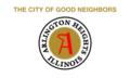
Flag of Arlington Heights
-
Coat of arms of Arlington Heights
-
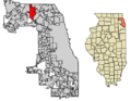
Location of Arlington Heights in Cook County, Illinois.
-
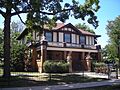
The Nathaniel Moore House is a historic building in Arlington Heights.
-

The grandstand at Arlington Park Race Track.
-
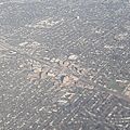
An aerial view of downtown Arlington Heights.
-
Harmony Park in downtown Arlington Heights.
-
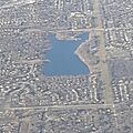
An aerial view of Lake Arlington.
-

Grandt's Shell in Arlington Heights.
-

St. Viator High School.
-
The Arlington Heights Memorial Library.
-
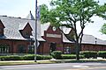
The Metra train station in downtown Arlington Heights.
See also
 In Spanish: Arlington Heights (Illinois) para niños
